How framework participants work together.
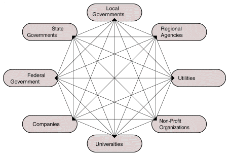
The framework is built and managed through the cooperative efforts of all participants -- local, regional, state, and federal government agencies; private sector companies; educational institutions; nonprofit organizations; and any others who wish to participate. The organization of framework participants is envisioned as a network, not a hierarchy.The framework takes advantage of geographic data that are being created and used locally by many different organizations. Integrating these disparate data sources requires many different functions distributed among many organizations. The guiding principle, however, is to keep operations as close as possible to local data producers and users.
Several critical functions are needed to develop and manage the framework. The tasks and issues that must be addressed within these functions are fairly clear. How organizations and individuals will take on roles that address these functions will vary among communities. These functions can be fulfilled in many ways; many organizations are already fulfilling similar roles in their multiparticipant GIS activities.
Framework Functions
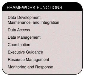
Various related functions are necessary to build and operate the framework. Seven primary functions have been identified: data development, maintenance, and integration; data access; data management; coordination; executive guidance; resource management; and monitoring and response. Each function has several related activities and responsibilities, and each one involves particular problems and challenges.
Framework Participant Organization Figure 4.1

Framework Functions Figure 4.2
Data Development, Maintenance, and Integration
Data development and maintenance activities create and update framework data. These functions involve generating original data and revisions, merging spatial and attribute data from different sources, documenting the data (creating metadata), and evaluating and integrating the data.Framework data may be generated through a variety of techniques and sources, including field surveys, photogrammetric compilation, digitized maps, and conversion of other records to digital data. The quality of all data incorporated into the framework must be tested and reported. Existing databases often include the information content of the framework. Participation in the framework may be as simple as providing an extract from a current data holding.
Different organizations may provide various elements of framework information. For example, one organization may provide road centerlines; others may provide related attribute data such as street addresses. Development of the framework requires the merging of these data to create roads with street address information.
In common practice, organizations usually generate data that meet their business needs and so may not collect data for all framework data themes. Their data may match related data from other themes poorly. Organizations also usually map only their jurisdictions. Therefore, their data may overlap other collections where jurisdictions overlap, or may match the data collected for surrounding jurisdictions poorly where jurisdictions abut. One consequence of overlapping data collections is a need to evaluate and select among data for inclusion in the framework. Another consequence is that the needs and jurisdictions of an organization may not coincide with those of other potential users. Horizontal integration (among jurisdictions) and vertical integration (among themes) provide the consistency desired by users; therefore, data integration is an important task in constructing the framework.
As framework data are established for an area, maintenance becomes an increasing concern. There is a continuing need to maintain the currentness of the spatial and attribute data. Other activities include improving positional accuracy of the data by replacing or repositioning the spatial data, increasing the data density (for example, by adding minor streams not collected originally), and adding aliases for attribute data (such as alternate street names that are used locally).
Users' ability to understand and apply framework data appropriately is vital to the success of the framework. Consistency in data definition, documentation, and organization helps ensure the utility of the framework data. The developing standards and guidelines for the framework document the elements for which consistency is desired. In addition to helping users understand the content of the framework, these standards and guidelines provide a useful guide for getting started to those who are just beginning to produce geographic data.
Framework Data Producers
Data producers include local, regional, state, and federal governments; private sector companies; universities; nonprofit institutions; and others. Local government agencies typically produce the most detailed or highest-resolution data for all themes, and these themes frequently are coordinated through a GIS project. The coverage of these data sets usually is limited to the geographic area served by the agency. State and federal agencies tend to produce data of lower resolution covering larger geographic areas. These data sets are often limited to themes that relate to the agencies' individual activities. State and federal agencies also produce high-rsolution data for selected facilities or project areas. The private sector produces a variety of data sets for different resolutions, geographic areas, and themes. Some companies produce many data themes at high resolutions for selected project areas. Others produce single data themes, such as imagery or street networks, at low resolutions over large areas. Integration develops geographic and thematic consistency among data provided by these different organizations.
Data Access
Data access enables participants to obtain framework data. The major activities include providing access to data and metadata, processing data requests and charges, determining and providing needed data distribution formats, and reporting and acting on users' concerns. This function also directs users to other resources.Marketing is an important aspect of data access and includes product definition, packaging, and documentation; product support; distribution channel development; and product and service promotion and advertising. The framework must be able to respond to market conditions and demands, such as needs for generalized data and customized sets of data and products. In addition, the community must be informed that framework data exist and be educated about how to obtain, use, and possibly contribute to the data. The data access function addresses all these needs; it also collects information useful for detecting trends among users.
The National Geospatial Data Clearinghouse provides an important means for carrying out data access responsibilities. The clearinghouse enables users to find, evaluate, and access geographic data through the Internet. By making framework metadata and the framework data themselves available, the clearinghouse can make the framework accessible to many users who might otherwise be unaware of these resources.
Data Management
Data management ensures the continued viability of framework data. Activities include maintaining data; ensuring data integrity and security; developing and evolving data definitions, designs, and models; developing and evolving other technical specifications; and providing for data archive, backup, retrieval, and disaster recovery.An important goal of data management is to ensure that a whole framework can be assembled from its parts. The large scope and distributed nature of the framework present the most formidable challenge. Data management activities occur in many different places and organizations, and the framework data management function must tie these activities together.
Coordination
The contributions of many organizations create the framework. Coordination ensures that these contributions -- data, funding, technology, and people -- meld smoothly, and encourages productive relationships among the participants. This function entails fostering cooperation and partnerships among organizations, implementing processes and incentives that encourage widespread participation, encouraging practices that provide for smooth operations, and mediating and resolving conflicting priorities and disputes among participants. Specific activities include creating business plans for framework development, establishing priorities, developing agreements and business practices that encourage participation, coordinating data access methods, developing consensus on standards, and providing outreach and education. Coordination activities identify barriers to participation caused by organizations' policies and business practices, and develop alternatives.Coordination maximizes community participation in framework development. Both formal and informal agreements are useful. Agreements should provide "wins" for all parties, and should maintain flexibility and accommodate in-kind contributions.
Coordinating data development also is an important role. This activity entails working with organizations to avoid duplicating efforts, identifying data to be incorporated into the framework, pooling available resources, and ensuring that data are produced for all geographic areas and themes.
Executive Guidance
Executive guidance provides vision and direction for framework development, and has the ultimate responsibility for the framework's success. Activities include developing a shared vision among stakeholders; developing a strategic plan for the enterprise; establishing organizational structures, operational environments, orderly communication methods, decision making, and other governance processes; developing and maintaining policy and funding support for the effort among senior executives and other influential parties; and providing a legal foundation for contracts, liability, and other issues.Gaining and maintaining acceptance of the vision and strategy for framework development is an important responsibility of executive guidance. The voluntary and continuing nature of the framework and the evolutionary aspects of its development are challenging nature of this task. Continual education and outreach is essential. Potential stakeholders are often at different stages of operational maturity and sophistication, and must be educated about geographic data sharing and the framework. The attention, endorsement, and support of public officials and senior policymakers must be cultivated and maintained, but the voluntary nature of their interest, turnover among policy participants, and issues competing for their attention make this task difficult. Organizations may need to change their policies and practices to take better advantage of the framework. Policy development activities can educate executives about the implications of these practices and rally support for changes.
Resource Management
Leveraging framework development efforts with those of other activities can increase the available resources. Resource management includes responsibilities for estimating income and expenses; identifying, obtaining, and allocating resources; and providing logistical support for framework development. Resources include funding, data, technology, and people. Funding sources include appropriations, grants, service contracts, joint development agreements, and fees and similar sources of income. The utility of available funding is a concern if funding is accompanied by unacceptable constraints, such as incompatible data formats or restrictions on use. Expenses include labor costs, contracts, supplies, equipment, and indirect costs. Resource management considers not only the amount of expenditures, but also their effectiveness.
Monitoring and Response
The monitoring and response function measures users' satisfaction with the framework and provides for market analysis. Users need data to assist their decision making and support a range of applications over their geographic areas of interest. Data must be in a form that can be readily incorporated into their operations. Users must be able to add information to the data and modify and integrate framework data with other information.Users are sensitive to the quality of the data -- currentness, accuracy of positional and attribute information, completeness, and consistency. Data must be well documented. Consistency across a study area and among data themes is important. Data must be readily accessible. Online access is preferred, but does not preclude other forms of access. Users also are sensitive to charges for data. The monitoring and response function assesses users' satisfaction with the framework, identifies new needs, and develops responses to their concerns.
Market analysis uses this and other information to ensure that the framework continues to meet the community's needs. This activity includes identifying target markets and potential customers, the current and potential size of markets, competition, and market trends and forecasts. Framework marketing must be proactive and promote the building and use of the framework.
Organizing the Functions
Successful framework development depends on all of these functions. Framework participants may perform any of the functions and may perform different functions at different times, for different data themes, or as part of different activities. Some organizations are already performing these functions through GIS consortia and partnerships in their communities.An organization may perform one or more functions. For example, it might perform data development only, or also provide data maintenance and integration services. Organizations with data exchange infrastructures might specialize in data access.
Functions may evolve over time. An organization that produces and integrates data, for example, may evolve to concentrate on integration as other participants become sources of data and updates. An organization that produces data for a theme that meets its needs but is outside its business expertise may become a net consumer of data as the framework matures and provides a dependable source of data. For example, a transportation organization that produces hydrography data to meet its needs may find that it can reduce these efforts as framework activities for hydrography data mature.
Organizations often will take on different functions for different themes. For example, an organization that has responsibilities for natural resources may have a prominent role in organizing and operating activities for hydrography data, but may be much less active in activities related to transportation data. In some cases, participants find that an organization that is neutral in issues related to a theme of data is best positioned to facilitate the development of the framework.
Framework development can occur more quickly when it is based on and reinforces current flows of data among organizations. Framework development also is facilitated when it helps to solve an issue of widespread interest in a locality. The issue can be as simple as providing pricing discounts on volume purchases of data.
These realities help guide efforts to organize the development of the framework for a geographic area. Organizations' roles will evolve over time and will vary for different data themes. Flexibility is essential. Early efforts to organize the framework often emphasize issues related to data production, maintenance, and integration. These concerns must be balanced with those of other functions. Existing relationships and interests among organizations provide a basis for cooperation and framework development. There are many different ways to distribute framework functions among participants. Each framework community must be creative in encouraging participation and organizing a structure for participation.
Framework Organizational Structures
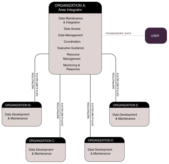
Organizational models for developing the framework in a geographic area can be positioned along a spectrum according to the amount of centralization in the execution of framework functions. The extreme ends of the spectrum -- centralized and decentralized models -- are characterized below; most implementations will fall somewhere in between these two extremes.In the centralized approach, one organization performs most functions except for production of the initial data and subsequent updates. A major activity is data integration; this role is termed "area integrator." The area integrator carries out other technical tasks such as implementing standards and quality assurance procedures, coordinating data creation and maintenance activities among organizations that produce data for the geographic area, and incorporating updates into the centrally held framework data. The area integrator assumes sole responsibility for the functions of data access, data management, resource management, monitoring and response, coordination, and executive guidance. Other organizations contribute copies of data, updates, and related metadata to be integrated into the central framework data holding, and use framework data. In this model, the area integrator may be identified and assigned its functions by the community, or it may assume these responsibilities on its own.
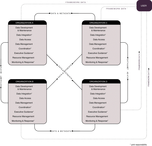
The decentralized approach features many organizations within a geographic area taking on several functions in a closely coordinated, networked structure. Within its jurisdiction, each organization performs framework functions and carries out the technical tasks performed by the area integrator in the centralized model. The organizations jointly address common concerns for other functions. Where organizations have adjacent jurisdictions and overlapping themes, they jointly resolve discrepancies among their data. Instead of a central holding, the participating organizations hold framework data for their own jurisdictions; the Internet provides for access to the distributed holding of framework data.
Other options exist between these extremes. For example, a consortium that uses a decentralized approach may choose to have one organization provide some functions, such as data access and monitoring and response, for the group. A group of organizations might provide guidance and oversight to an otherwise centralized activity. The interests and abilities of organizations to carry out the functions required for the framework will guide the approach taken by different consortia.
Organizational Foundations
The framework is built from the ground up. Many organizations are undertaking framework-like efforts within their own localized GIS consortia and projects. These coordination efforts tend to fall into three general categories:
- State-based coordination. A state government entity leads the coordination efforts among state agencies, federal agencies, local governments, and others. This approach operates in several states.
- Regional consortium. Organizations that have a sustained interest in a region (within or across state boundaries) form a consortium to develop shared data. These consortia may include local and regional government agencies, state and federal agencies (especially those that have operational responsibilities in the region of interest), and others. For example, there are several GIS consortia that involve counties, cities, towns, regional agencies, and utilities within a region.
- Special project. In cases where there is an issue of common
interest in a geographic area, organizations form a partnership to
develop shared data to address the issue. These projects usually have a
limited life span, defined by the project goals. For example, some GIS
projects have been initiated so that local branches of federal agencies
can work with local governments and others on environmental issues.

Centralized Model Figure4.3

Decentralized Model Figure4.4
Tying Framework Efforts Together
A goal of the framework is to provide consistent data coverage that aids users working in geographic areas of different sizes and shapes. The framework also supports users who need both detailed and generalized data. These realities mean that users will inevitably require data from more than one framework effort. For example, a state agency may need data from several regional framework efforts within the state to identify state-owned properties. To respond to a flood, emergency managers may require data from several framework efforts to cover the affected area. The needed data may span all or part of several regional or even statewide framework efforts.Because the framework is built from the ground up, results from many individual efforts may not yield the consistency users need. Some additional activities are needed to achieve this consistency, to aid the development of individual framework efforts, and to tie framework efforts together. These activities include the following:
- refining strategies and concepts to sustain and evolve the framework;
- drafting, reviewing, and approving standards;
- developing policies for verifying the quality of data;
- developing data management procedures;
- supporting development of needed technologies; and
- educating participants about the framework.
- recommending standards,
- identifying sources of funding and other resources,
- encouraging partnerships,
- implementing standards,
- initiating pilot projects,
- testing and implementing procedures and technologies, and
- resolving disputes and conflicts.

