Contents
Highlights of Fiscal Year 2006
Geospatial Data Fulfills Its Promise, Meets the Challenge
FGDC: Coordinating Development of the NSDI
FGDC: Leading Development of Integrated Geospatial Capabilities
Appendix C. Status of NSDI Framework Data Themes
Appendix D. Glossary of Abbreviations and Terms
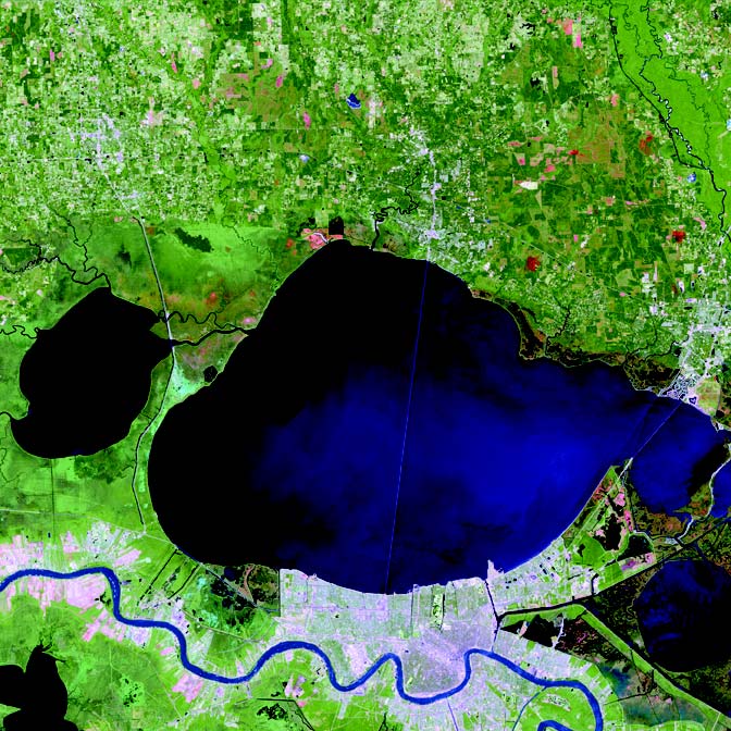
Image of New Orleans, Louisiana, using data provided by the U.S. Geological Survey Center for EROS and the Landsat Project Science Office at Goddard Space Flight Center. Jesse Allen/National Aeronautics and Space Administration image.
Highlights of Fiscal Year 2006
1. Geospatial Line of Business
The Geospatial Line of Business was launched in March 2006 as part of the President’s 2007 budget. The staff director of the Federal Geographic Data Committee (FGDC) is the managing partner for this presidential initiative. An interagency task force is identifying opportunities to optimize, standardize, develop accountability and improved performance in Federal geospatial activities, and support the further development of the National Spatial Data Infrastructure (NSDI). For the complete story, click here.
2. NSDI Cooperative Agreements Program Grants
For 12 years, Cooperative Agreements Program grants have played a substantial role in promoting and disseminating the tenets of the NSDI to thousands of practitioners by providing small seed grants to organizations. The program emphasizes partnerships, collaboration, and the leveraging of geospatial resources to achieve its goals. In fiscal year (FY) 2006 a new category for NSDI expansion at State and local levels debuted as the Fifty States Initiative. Read more information here.
3. Fifty States Initiative
FY 2006 was the inaugural year for the Fifty States Initiative. The FGDC and National States Geographic Information Council endorsed this planning process. The initiative is targeted to meet State and local needs by institutionalizing statewide geospatial information coordination and governance to advance the NSDI. For more information, click here.
4. Governance
The FGDC moved toward establishing a new inclusive NSDI governance model to ensure input and commitment from all non-Federal stakeholders. The National Geospatial Advisory Committee will be established under the Federal Advisory Committee Act. The committee will advise the FGDC on matters related to national geospatial programs and further development of the NSDI. Click here for additional information.
5. International Collaboration
The FGDC provided management and planning support for the 9th International Conference of Global Spatial Data Infrastructure Association in Santiago, Chile. Partnership agreements with international associations, signed in FY 2006, are paving the way for more extensive international collaboration and training. For the full story, click here.
6. Geospatial One-Stop
The Geospatial One-Stop (GOS) portal, www.geodata.gov, the official means to access the metadata resources managed in the NSDI Clearinghouse Network and other authoritative sources, saw an increase of more than 30 percent of the accessible metadata records during FY 2006. The GOS Partnership Marketplace, which allows organizations to publish their intent in collecting geospatial data, grew to include approximately 3,000 planned data acquisition records by the end of FY 2006. For more information, click here.
7. Geospatial Profile for the Federal Enterprise Architecture
A Geospatial Profile for the Federal Enterprise Architecture (FEA) was published in January 2006. It provides agency business architects with the references and background to recognize and incorporate common geospatial capabilities in their business planning. It is one of three published FEA profiles. For the complete story, click here.
8. Symbology Mapping Standard
The FGDC’s Homeland Security Working Group developed a standard symbol set for emergency management and response. This effort resulted in the publication of an American National Standard (ANS), Homeland Security Mapping Standard—Point Symbology for Emergency Mapping in FY 2006. See here for more information.
9. Framework Standards
The International Committee for Information Technology Standards Technical Committee L1 approved the Framework Data Standard for further processing to become an ANS. The Framework Data Standard was created to enable data exchange for seven fundamental geospatial themes of critical importance to the development of the NSDI. For more information, click here.
10. Imagery for the Nation
During FY 2006, the National Digital Orthophoto Committee endorsed the initial Imagery for the Nation proposal. Activities included developing Federal needs, identifying the program costs, and funding a cost-benefit analysis study. Read more information here.
Success Stories
Enhancing Data Coordination To Leverage Other Investments
Challenge: The Department of Homeland Security’s Federal Emergency Management Agency (FEMA) needed to improve the levels and quality of its coordination in collecting and managing geospatial data under FEMA’s Map Modernization Program.
Action: FEMA focused on outreach to State and local partners through its regional offices and mapping contractors. Regional Management Centers (RMC) developed working relationships with National States Geographic Information Council representatives in their States to facilitate a coordinated approach to data sharing. RMCs also entered metadata records into the National Digital Elevation Program and National Digital Orthophoto Programs project tracker Web sites for any State and local elevation data sets planned for use on FEMA Digital Flood Insurance Rate Map projects for 2006 in their region.
Result: During 2006, FEMA leveraged $33 million in terrain data, orthophotography, and geospatial data, based on an investment of approximately $3.9 million. Notably, FEMA partnered with the U.S. Army Corps of Engineers to obtain terrain information developed by the Corps. FEMA inventoried more than 600 elevation data sets and more than 580 imagery data sets. These data sets will be cataloged on the FEMA Mapping Information Platform (see www.hazards.fema.gov). The 133 Urban Area Initiative at National Geospatial-Intelligence Agency (NGA) and U.S. Geological Survey (USGS) collects high-resolution orthophotography and LIDAR of the defined urban areas. A 5-mile buffer was established around the defined urban areas to capture all potential FEMA projects that might produce data useful to NGA and the USGS.
Collaborating and Collecting Imagery in Nevada
Challenge: National Agricultural Imagery Program data were needed for agricultural lands in Nevada. The challenge was to coordinate entities at the Federal, State, and local levels and raise $1.6 million in funding.
Action: The effort became a statewide interagency project. Participants included the U.S. Bureau of Land Management, U.S. Fish & Wildlife Service, U.S. Geological Survey, U.S. Natural Resource Conservation Service, Nevada Department of Transportation, Nevada Bureau of Mines and Geology, Southern Nevada Water District, Washoe County, and University of Nevada Reno—Keck Library.
Result: Data are currently being captured. They will be shared among participating entities and made available to the public.
I am pleased to present the Federal Geographic Data Committee (FGDC) 2006 Annual Report, showcasing the many collaborative activities and accomplishments of the FGDC and the geospatial community during the past year.
A key activity was the March 2006 launch of the Office of Management and Budget’s Geospatial Line of Business (LoB) initiative, part of the President’s Management Agenda. The Geospatial LoB leverages our resources, increases accountability, and optimizes Federal geospatial-related investments while improving service to citizens.
For non-Federal stakeholders, the proposed National Geospatial Advisory Committee represents a new phase in the ongoing development of the National Spatial Data Infrastructure (NSDI). The committee will provide a productive forum to convey the views of non-Federal stakeholders in the geospatial community.
The geospatial technology, Web services, and other information available today are easier to use and have become integrated into daily life. Our society benefits from new navigation and Global Positioning System tools, online 3-D maps, sensor systems to predict and monitor natural disasters, and critical homeland security information.
Timely, accurate data are critical for these technologies and services. This annual report highlights key areas of progress in the NSDI’s evolution and looks ahead to the continuing role that geospatial information will play in America’s future. For a more in-depth analysis of these topics, please visit the FGDC Web site (www.fgdc.gov) or the Geospatial One-Stop Web site (www.geodata.gov ).
I am proud of the accomplishments of the geospatial community and appreciate the contributions of those involved in the continuing development of the NSDI. We all look forward to making the NSDI an even more important part of America’s digital data foundation in the years ahead.
Sincerely,
Lynn Scarlett, Deputy Secretary
U.S. Department of the Interior
Chair, FGDC Steering Committee
Geospatial Data Fulfills Its Promise, Meets the Challenge
If a disaster struck your region, would you know how to find the information needed to respond effectively? What information would be critical? Does it exist? Could you find it quickly?
For more than a decade, the geospatial community has worked to answer those questions for the Nation. In fiscal year (FY) 2006, the effort to create a National Spatial Data Infrastructure (NSDI) reached an important milestone: the U.S. Office of Management and Budget, recognizing the critical need for ready access to reliable data, launched the Geospatial Line of Business (LoB) to identify opportunities for optimizing and standardizing Federal geospatial-related investments to reduce the cost of government and improve services to citizens.
Good decisions require good information. It is widely accepted that 80 to 90 percent of government information has a geospatial component. Government managers and business leaders need geospatial data they can trust—data that are accurate, reliable, timely, accessible, and easy to use. America’s ability to effectively share, use, and reuse this valuable information across government depends on the policies, standards, and partnerships that form a strong NSDI.
The NSDI ensures that spatial data from multiple sources are available and easily integrated to help decision makers choose the best course(s) of action. Although much has been accomplished in recent years to further NSDI’s implementation, the cross-agency coordination of geospatial activities still is needed to identify, consolidate, and eliminate redundant investments. Implementing the Geospatial LoB recommendations will result in a more coordinated approach to produce, maintain, and use geospatial data.
The Federal Geographic Data Committee (FGDC) is charged with implementing the NSDI. This report summarizes key developments in the evolution of the NSDI during FY 2006. It provides an overview of specific challenges being met through enhanced geospatial information and improved methods for collection, storage, and distribution of that information.
NSDI Drives Future Hurricane Recovery and Preparation
For America’s Gulf Coast, 2006 brought cleanup and recovery from the Nation’s most devastating hurricane season, which occurred in 2005. Hurricane Katrina, one of the most destructive storms ever to strike the United States, was a Category 5 storm with sustained hurricane-force winds reaching 175 miles per hour and extending as far as 120 miles from the eye of the storm. Never before had the value of geospatial data been so clear and the applications of such data so critical as during the tracking, assessing, and recovery efforts before and after the storm.
NSDI Before the Storm
Agencies such as the National Oceanic and Atmospheric Administration (NOAA) and the National Geospatial-Intelligence Agency (NGA) were building data sets as part of the NSDI that became critical components in the post-Hurricane Katrina damage assessment and rebuilding.
NOAA’s height modernization program identified the vulnerability of certain areas to flooding. Immediately following the storm warnings, this elevation data enabled local authorities to evacuate the areas at greatest risk.
Well before Hurricane Katrina made landfall, NGA began collecting key infrastructure-related information regarding airports, hospitals, police stations, emergency operation centers, highways, and schools. This crucial information aided emergency responders immediately following the storm.
The Natural Resources Conservation Service, through its National Geospatial Development Center, prepared several thematic maps of the anticipated path of Hurricane Katrina in Louisiana, Mississippi, and Alabama. The creation of these maps began 3 to 4 days before the hurricane’s anticipated landfall, in time for distribution to the first responders from the U.S. Department of Homeland Security (DHS).
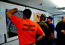
9th Ward, New Orleans, Louisiana, March 15, 2006. Chris Diamond, Search and Rescue, St. Louis, Missouri; Charles Gordon, U.S. Army Corps of Engineers (USACE), Greenville, Mississippi; and Gary Simon, New Orleans Fire Department, plan the day’s search and recovery activities using aerial and grid maps in this mobile command center. All homes being demolished in the 9th Ward are searched by a search and recovery team so that no human remains are left in houses that are being demolished. Marvin Nauman/Federal Emergency Management Agency (FEMA) photo.
Assessing the Damage
NOAA delivered posthurricane and tropical storm aerial imagery to the public in coordination with Federal, State, and local governments. Damage assessment flights began quickly and thousands of geospatial images were generated for government and public use. NOAA’s aerial photography database was a boon to property owners who could not immediately return to check on their homes or businesses but could examine their properties via the Internet. NOAA’s aerial photography Web site received more than 72 million hits in the month following Hurricane Katrina.

9th Ward, New Orleans, Louisiana, March 11, 2006. FEMA debris inspector Drew Dunne, USACE inspector Tom Conway, and ECC Operating Services inspectors Hillsay Careaer and Rata Murr give this house in the 9th Ward the final verification inspection for demolition for homes in the public right-of-way. All 9th Ward homes sitting on public right-of-way must be demolished and receive several verification inspections, including this final predemolition checklist inspection. Marvin Nauman/FEMA photo.
In February 2006, the U.S. Department of Housing and Urban Development (HUD), Office of Policy Development and Research (PD&R) estimated that nearly 1.2 million housing units were damaged or destroyed by Hurricanes Katrina, Rita, and Wilma. PD&R developed the data for an allocation formula dividing $16.7 billion in congressionally authorized Community Development Block Grant funding for long-term recovery among Alabama, Florida, Louisiana, Mississippi, and Texas. This effort drew on information from many agencies: Census 2000 data, Federal Emergency Management Agency (FEMA) maps of the extent of overall damage from the hurricanes, NOAA surveys showing floodwater depth, and HUD’s own records.
Another imagery source was the Farm Service Agency (FSA) of the U.S. Department of Agriculture (USDA). Each year, during the agricultural growing season, FSA’s Aerial Photography Field Office acquires imagery across the Nation through the National Agriculture Imagery Program (NAIP). In many cases, this imagery is the most current preevent natural color or color infrared imagery. In the NAIP, within 3 days of receipt, a compressed county area mosaic of the imagery is available via USDA’s Geospatial Data Gateway and is prepackaged for quick delivery upon request. After the hurricanes dealt their destructive blows, this system enabled FSA to create a public Web service for NAIP imagery to aid emergency response.
The Environmental Protection Agency (EPA) and contractors developed more than 10,000 relevant maps for responders and reconnaissance crews. Map requests came from various sources and with different formats and requirements. EPA developed a specialized tracking system enabling staff and customers to track the status of individual map requests. Known as “Map Tracker,” this Web-based inventory allowed users to request maps and then track the maps to completion. The tool greatly improved the efficiency, consistency, and timeliness of product development to meet emergency response needs.
The U.S. Census Bureau estimated that Hurricane Katrina affected nearly 10 million Gulf Coast residents. To meet the need for predisaster and postdisaster population data in hurricane-affected areas, the Census Bureau created two special products: one based on county population estimates in the months before the event and the other based on county population estimates in the months after the hurricanes occurred.

New Orleans, Louisiana, Red Tag Map showing important cultural resources possibly impacted by Hurricane Katrina. National Park Service image.
Hurricane Katrina was especially destructive to historic structures. Many communities lost treasured cultural resources, including historic commercial buildings and homes. Others had to decide whether to repair or demolish damaged historic properties. The National Park Service Cultural Resource Geographic Information System (GIS) Facility developed and implemented a historic preservation data management system for New Orleans and the seven surrounding parishes. This work was done in consultation with the Louisiana State Historic Preservation Office and the New Orleans Historic District Landmark Commission.
The Tennessee Valley Authority (TVA) Transmission Emergency Operations Center (TEOC) needed a way to quickly view transmission assets (structures, lines, and substations) and electric power customers in affected areas. TVA developed a GIS approach, drawing data from the Power System Operations work management system and the incident database. This approach enabled TEOC staff to rapidly display the location of affected assets and customers and to track and guide system operations throughout the emergency.
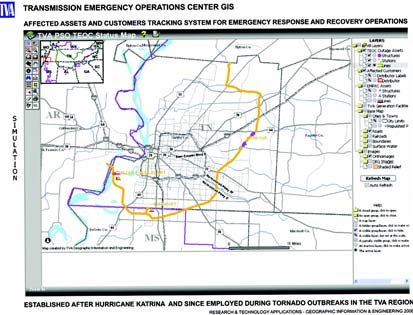
Transportation Emergency Operation Center Geographic Information System is an affected assets and customers tracking system for emergency response and recovery operations. Established after Hurricane Katrina, it has since been employed during tornado outbreaks in the Tennessee Valley Authority region.
Storm Surge and Flooding
Hurricane Katrina produced a storm surge of 24 to 28 feet along the Mississippi coast. The surge appeared to have penetrated at least 6 miles inland. In New Orleans, where the storm surge was 12 to 19 feet, levees protecting the city failed or were overtopped by the surge. Overall, 80 percent of New Orleans was flooded, and some areas were under water at a depth of up to 20 feet.
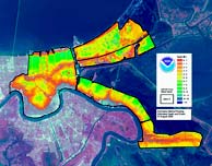
Hurricane Katrina Flooding, Estimated Depth and Extent, New Orleans, Louisiana, August 31, 2005. National Oceanic and Atmospheric Administration (NOAA) image.
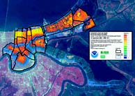
Hurricane Katrina Flooding, Estimated Depth and Extent, New Orleans, Louisiana, September 14, 2005. NOAA image.
After the levees failed, efforts shifted to acquire aerial imagery of the inundated areas. NOAA worked to ensure the greatest efficiency for imagery acquisition. In the course of 9 days, 19 flights captured more than 8,400 high-resolution digital images. NOAA moved quickly—faster than during any previous hurricane season. From the time the agency acquired the images, it processed and disseminated data via the Internet in less than a day.
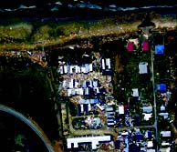
Levee failure at New Orleans, Louisiana. National Oceanic and Atmospheric Administration photo.
HUD used FEMA data to determine if housing units were within flood zones. Working with geocoded FEMA-registered housing units and FEMA flood coverage data, HUD was able to correlate household and housing characteristics by extent and type of damage.
In Orleans Parish, floodwaters inundated local government buildings containing vital records. National Archives and Records Administration personnel transferred the waterlogged records in freezer trucks to a New York State processing facility. After processing to preserve them, the property deeds and other georeferenced records were returned to Orleans Parish.
The wetlands of the Gulf Coast area also suffered from Hurricane Katrina’s impact. A U.S. Geological Survey (USGS) analysis indicated that 217 square miles of Louisiana’s coastal lands were transformed to water following Hurricanes Katrina and Rita. Lacking access to digital wetlands data, Federal agencies and land managers had difficulty planning cleanup, site restoration, and management.
The U.S. Fish & Wildlife Service (USFWS) National Wetlands Inventory partnered with the USGS National Wetlands Research Center to convert existing inventory maps into digital data depicting wetland conditions before Hurricanes Katrina and Rita came ashore. This partnership aided recovery and planning efforts through Internet distribution of data for nearly 12 million acres of digital wetlands.
Preparing for Future Events
Responding to the need for improved access to geospatial data in the aftermath of Hurricane Katrina, DHS leveraged its highly successful partnership with USGS and NGA to fund imagery programs to meet Federal, tribal, State, and local needs. This partnership helps Federal agencies maximize their response and recovery efforts. USGS Geospatial Liaisons identified imagery programs at the State and local levels and leveraged Federal funds to support the common imagery. This effort has generated a 16:1 return on investment, because the $4.4 million DHS invested leveraged approximately $70 million from State and local orthophotography programs.
Other GIS and remote sensing support for disaster recovery includes the continued development of spatially enhanced forecast products, development of inland flood inundation maps to enhance NOAA flood forecast products, and continued assistance with the improvement of storm surge modeling and water-level forecast products. Additional work includes the development of satellite-based maps to help officials visualize impacted areas and debris accumulations. NOAA and FEMA continue to coordinate and collaborate on risk and vulnerability methodologies and on new mapping technologies. This partnership has allowed for the development of an updated vertical datum in southern Louisiana. A new geospatial services contract now allows for the collection and development of geospatial data and products—and access to those data and products—following a major weather event.
The EPA Map Tracker was initially developed specifically for Hurricane Katrina response. Map Tracker is now being modified for deployment on an enterprisewide scale for subsequent emergencies.
National Aeronautics and Space Administration (NASA) research data are being used to prepare for and respond to future tropical weather emergencies. The Modeling, Analysis Prediction ‘06 Project, affiliated with NASA’s Modeling, Analysis, and Prediction program, will apply NASA’s advanced satellite remote sensing technologies and earth system modeling capabilities to enhance understanding of tropical cyclones in the Atlantic Basin.
NSDI’s Contributions in Other Critical Situations
Just as geospatial data played a critical role in hurricane recovery along America’s Gulf Coast, the rapidly developing technology and stores of knowledge continue to be used by numerous Federal, State, and local agencies to address the need for emergency response in other disaster situations.
Building the NSDI To Protect Our Homeland
Through the development of an infrastructure database, NGA has moved to the forefront of the homeland security community as a broker of imagery, elevation data, and vector data sets (graphics-based geographical features). In recent years, NGA has contracted for the acquisition and integration of airborne imagery of nearly 100 high-priority urban areas. By the end of 2006, analysts had used the imagery to create high-resolution, three-dimensional models and visualizations for many of these areas.
The agency also obtained local imagery and other data from cities hosting special security events. NGA partnered with other agencies to collect high-resolution, color airborne imagery to support DHS in its security efforts at venues such as the World Series baseball games and special meetings at the United Nations. In addition to collecting imagery, NGA acquired, integrated, and/or updated a variety of data sets on 11 critical infrastructure sectors that DHS identified.
NGA provides users with a common operational picture that enables them to visualize that picture, analyze it, and act on it. Users include the White House Situation Room, DHS’s Homeland Security Operations Center, the U.S. Northern and Joint Forces Command, the Federal Bureau of Investigation, the National Counterterrorism Center, and the Transportation Security Administration’s operations center.
Managing and Combating Wildland Fires
In FY 2006, the USDA Forest Service made enhancements to the Phoenix airborne thermal infrared fire detection system. The system now provides digital geocorrected imagery to emergency fire personnel. This important enhancement has resulted in significant savings in time for producing fire perimeter maps, active fire front maps, and hot spot maps.
During FY 2006, the Bureau of Land Management (BLM) completed inventories of cadastral data in the West and in the Gulf Coast to help address wildfire and hurricane threats, respectively. BLM assisted fighters of wildland fires in the West by providing cadastral data to determine “values at risk.” Economic analyses of values at risk in comparison to the costs of fire response assisted in developing improved strategies for wildland firefighting.
NASA’s Moderate Resolution Imaging Spectroradiometer (MODIS) Rapid Response research applications prototype is a key data source in fighting wildland fires. The system initially gained prominence during a 2000 fire outbreak in Montana. MODIS imagery and data now are provided to such organizations as the USDA Forest Service’s Remote Sensing Applications Center, the National Interagency Fire Center, and the United Nations Global Fire Monitoring Center.
Preparing for Bird Flu
Infectious disease specialists at the Centers for Disease Control and Prevention and the USDA’s Animal and Plant Health Inspection Service (APHIS) asked USFWS to help assess the threat level from avian influenza (bird flu), based on transmission of the virus via wild populations of migratory waterfowl or water birds.
USFWS provided its wetlands digital data set for the avian influenza study. This effort involved coordination with APHIS specialists to provide digital wetlands data in proper format plus development of a grid system to partition the data and determine the size and location of water bodies and wetlands that would support migratory birds. APHIS will use this information to develop models of areas susceptible to avian influenza outbreaks.
Promoting and Ensuring Interagency Interoperability
The September 11, 2001, terrorist attacks required first responders from many different jurisdictions to work together—a first-time experience for some. The operation exposed problems with interoperability, including the need for standardized symbology for emergency managers and first responders.
To solve this problem, FEMA led a symbology Working Group under the FGDC’s Homeland Security Working Group to develop a symbol set for emergency management and response. This interagency effort resulted in the publication of an American National Standard.
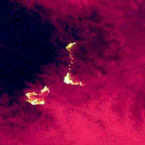
Two lightning-ignited wildfires burned in the San Bernardino Mountains near the town of Yucca Valley in July 2006. The smaller Millard fire reached a size of 24,000 acres before combining with the larger, 61,000-acre Sawtooth fire to the east. Together, they scorched 58 homes before this wildfire complex was contained. Within a week of this wildfire’s containment, lightning sparked several new fires in this drought-stricken area. Landsat, U.S. Geological Survey image.
Conclusion
These stories illustrate a few ways in which geospatial information was instrumental in dealing with disasters such as America’s most devastating hurricane season. These examples also show key developments in the evolution of the NSDI during FY 2006. They show how Federal government agencies are meeting specific challenges through the development and use of enhanced geospatial information and improved methods for collecting, storing, and distributing that information. They also show how the development and enhancement of the NSDI is preparing America for increasingly better response to future catastrophic events.
Success Stories
Mapping Tools for Marine Environment Management
Challenge: Under the Energy Policy Act of 2005 and Office of Management and Budget Circular A-16, the Minerals Management Service of the Department of Interior was required to develop a digital multipurpose marine cadastre to provide multiple users with Web-based mapping tools for better management of the marine environment.
Action: Plans were developed for an Internet mapping system that displays many different marine-related data layers in a seamless view, based on OGC (Open Geospatial Consortium, Inc.®) specifications.
Result: Work has begun to produce interoperable Internet mapping sites at participating agencies. Both government and the private sector will feed information into a central data viewer built specifically for this project. These same Web services also will be made available via Geospatial One-Stop, under the Oceans community.
Sharing Data Between State and Federal Agencies
Challenge: Effectively sharing the same critical infrastructure data between State and Federal agencies often is problematic.
Action: The State of Arkansas partnered with Techni-Graphic Services, Inc. (TGS) to share data with the National Geospatial-Intelligence Agency (NGA). The State and NGA provided information on selected critical infrastructure to TGS, which modified the data according to NGA procedures. The data were then forwarded to NGA and the State of Arkansas.
Result: This effort demonstrates that the States can both provide and receive benefits from participating in NGA’s development of a baseline of critical infrastructure information. The National States Geographic Information Council will strive to make this process available to all States, based on the success of the Arkansas pilot project.
FGDC: Coordinating Development of the NSDI
The explosive growth of technologies that produce and leverage geospatial information has created both enormous opportunities and considerable challenges for the Federal Government. Recognizing that effective use of geospatial information requires close coordination among the many agencies involved in its development, the Office of Management and Budget (OMB) in 1990 created the Federal Geographic Data Committee (FGDC) as the interagency coordinating body to promote development, sharing, and dissemination of geospatial data. The FGDC is charged with implementing the National Spatial Data Infrastructure (NSDI).
The NSDI encompasses the technology, policies, standards, and human resources necessary to acquire, process, store, distribute, and improve the usage of geospatial data for a variety of users nationwide. As the importance of geospatial capabilities to improve efficiency and effectiveness of government becomes more widely recognized, the FGDC is expanding its leadership role.
With the launch of the Geospatial Line of Business, the development of the Geospatial Profile of the Federal Enterprise Architecture, and the growth in Federal membership and collaborating partners in fiscal year 2006, the FGDC is seeking a more effective and inclusive governance structure for NSDI.
FGDC Structure
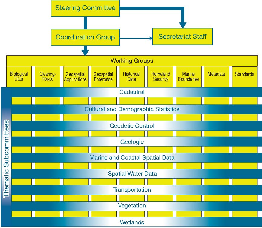
The FGDC is governed by a Steering Committee that sets high-level strategic direction. A Coordination Group advises on the FGDC’s day-to-day business, which is carried out by the FGDC Secretariat located at the U.S. Geological Survey (USGS).
The FGDC includes committees; agency-led working groups and thematic subcommittees; collaborating partners representing organizations from State, tribal, and local governments; and industry, academic, and professional groups. All participants initiate and support activities crucial to developing the NSDI.
Steering Committee
The Steering Committee is the policy-level interagency group responsible for overseeing activities related to OMB Circular A-16 and implementation of the NSDI. It provides executive leadership and establishes policy to coordinate geospatial activities between, among, and within Federal agencies. The committee meets quarterly in Washington, D.C. (See Appendix B, Exhibit 1 for a list of Steering Committee members and their associated organizations.)
Coordination Group
The FGDC Coordination Group advises on the day-to-day business of the FGDC, carrying out the interagency coordination and implementation of the NSDI at the operational level. It also facilitates and oversees the work of the FGDC Subcommittees and Working Groups. The Coordination Group, which meets monthly in Washington, DC, is composed of representatives from Federal agencies and collaborating partners.
Secretariat Staff
The FGDC Secretariat Staff provides support for the FGDC Subcommittees and performs various tasks such as analysis, technical development, and other activities on behalf of the Coordination Group. The Secretariat is located in the USGS, National Geospatial Program Office. (See Appendix B, Exhibit 3 for a list of Secretariat Staff members.)
Thematic Subcommittees
OMB Circular A-16 enumerates 34 data themes of national significance and assigns responsibility for each of the themes to one or more Federal agencies. The FGDC thematic subcommittees are established for nine of the data themes.
Thematic Subcommittee by Lead Agency and Definition
|
Thematic Subcommittee |
Lead Agency |
Definition of Spatial Data Theme
|
|
*Cadastral
|
DOI BLM
|
The geographic extent of past, current, and future right, title, and interest in real property; the framework to support the description of that geographic extent. Geographic extent includes survey and description frameworks. |
|
Cultural and Demographic Statistics
|
DOC USCB
|
Geospatially referenced data that describe characteristics of people: nature of structures in which they live, work; economic, other activities they pursue; facilities they use to support their health, recreational, other needs; environmental consequences of their presence; boundaries, names, numeric codes of geographic entities used to report information collected. |
|
*Geodetic Control
|
DOC NOAA
|
Common reference system for establishing coordinates for all geographic data. All NSDI framework data and users’ applications data require geodetic control to accurately register spatial data. The National Spatial Reference System is the fundamental geodetic control for the United States. |
|
Geologic
|
DOI USGS
|
Geologic mapping information and related geoscience spatial data that can contribute to National Geologic Map Database as pursuant to Public Law 106-148. |
|
Marine and Coastal Spatial Data
|
DOC NOAA
|
Data that exists within the Nation’s coastal zone, and data that exists within the Nation’s marine environment. Coastal spatial data are data that exist within the coastal waters and the adjacent shorelands. |
|
*Spatial Water Data (ACWI)
|
Co-leaders: DOI USGS and USDA NRCS
|
Develops water resource components of the NSDI through ACWI which advises the Federal Government, through DOI USGS, on the coordination of Federal water information programs; represents the interests of water-information users and professionals on activities and plans related to Federal water-information programs and the effectiveness of those programs in meeting the Nation’s water-information needs. Affiliated geospatial data programs include Watershed Boundary and National Hydrography. |
|
*Transportation
|
DOT BTS
|
Models geographic locations, interconnectedness, and characteristics of transportation system in the United States; includes physical and nonphysical components representing all modes of travel that enable movement of goods and people between locations. |
|
Vegetation
|
USDA Forest Service
|
Collection of plants or plant communities with distinguishable characteristics that occupy an area of interest. Existing vegetation covers or is visible at or above land or water surface and does not include abiotic factors that tend to describe potential vegetation. |
|
Wetlands
|
DOI USFWS
|
Provides classification, location, and extent of wetlands and deepwater habitats; no attempt to define the proprietary limits or jurisdictional wetland boundaries of any Federal, State, or local agencies. |
* Indicates framework theme.
Note: Abbreviations are defined in the glossary in Appendix D.
Working Groups
Working groups crosscut the subcommittees and focus on infrastructure issues common to many of the NSDI data themes.
Working Groups by Lead Agency and Description
|
Working Group |
Lead Agency |
Description
|
|
Biological Data
|
DOI USGS BRD
|
Promotes development and coordination of standards for biological data to increase compatibility in the development, use, sharing, and dissemination of biological data among government agencies and other interested institutions; develops means to facilitate the sharing and consistent use of biological data standards and protocols; encourages interagency partnerships in developing and implementing these standards and protocols; helps integrate biological data standards activities into the NSDI and the National Biological Information Infrastructure. |
|
Clearinghouse
|
DOI USGS
|
Tasked by Executive Order 12906 to develop procedures and helpimplement a distributed discovery mechanism for digital geospatial data. Using the data elements defined in the FGDC Metadata Standard, governmental, nonprofit, and commercial participants publish their geospatial resources to the Clearinghouse Network. |
|
Geospatial Enterprise Architecture
|
DOI USGS
|
Improves the understanding and integration of geospatial concepts by mainstream governmental business planners and technical practitioners through a variety of outreach mechanisms. The Community of Practice was convened at the request of the Architecture and Infrastructure Committee of the CIO Council and the FGDC to develop guidance known as the “Geospatial Profile of the FEA.” |
|
Historical Data
|
NARA
|
Established to promote awareness among Federal agencies of the historical dimension to geospatial data; to facilitate the long-term retention, storage, and accessibility of selected historically valuable geospatial data; and to establish a mechanism for the coordinated development, use, sharing, and dissemination of historically valuable geospatial data which have been financed in whole or part by Federal funds. |
|
Homeland Security
|
DHS
|
Ensures that the NSDI supports the preparation for, prevention of, protection against, response to, and recovery from threats to the Nation’s population centers and critical infrastructures that are of terrorist, criminal, accidental, or natural origin and related adverse events. |
|
Marine Boundary
|
DOC NOAA and DOI MMS |
Fosters integrated approaches to the legal and geospatial descriptions of marine boundaries and mapping of marine boundary features within the territorial waters of the United States; strives to make maximum use of public resources to avoid duplicating efforts, provide a venue for communicating and coordinating on marine boundary activities, and use standardized methodologies to produce more complete and usable marine boundary data, metadata, and charts. |
|
Metadata
|
DOI USGS
|
Promotes and coordinates geospatial metadata activities among FGDC member agencies in support of the NSDI; promotes awareness among FGDC member agencies of the metadata dimension to geospatial data; facilitates the evolution and revision of the Content Standard for Digital Geospatial Metadata; and establishes a mechanism for the coordinating, developing, using, sharing, and disseminating geospatial metadata among FGDC member agencies. |
|
Standards
|
DOI USGS
|
Actively promotes and coordinates FGDC standards activities; provides guidance on FGDC standards policy and procedures; facilitates coordination between subcommittees having overlapping standards activities; and reviews and makes recommendations on the approval of standards proposals, draft standards for public review, and draft standards for FGDC endorsement. |
Note: Abbreviations are defined in the glossary in Appendix D.
Collaborating Partners
The FGDC involves public interest groups that participate within the committee structure to ensure that their needs are included in developing the NSDI. These coordinating partners include State, local, and tribal governments; academic institutions; and a broad array of private-sector geographic, statistical, demographic, and other business information providers and users. NSDI strives to build upon local data wherever possible.
Collaborating Partners and Descriptions
|
Partner |
Description |
|
American Congress on Surveying and Mapping
|
A nonprofit educational organization that advances the sciences of surveying and mapping and related fields to further the welfare of those who use and make maps. |
|
Association of American Geographers
|
A scientific and educational society whose members share interests in the theory, methods, and practice of geography and geographic education. |
|
Cartographic Users Advisory Council |
An organization of 12 representatives from 6 national and regional library organizations, dedicated to cartographic interests. |
|
Geospatial Information and Technology Association |
A nonprofit educational association serving the global geospatial community. |
|
International City/County Management Association
|
A professional and educational organization for chief appointed managers, administrators, and assistants in cities, towns, counties, and regional entities throughout the world. |
|
National Association of Counties
|
Advances issues with a unified voice before the Federal Government, improves the public’s understanding of county government, assists counties in finding and sharing innovative solutions through education and research, and provides value-added services to save counties and taxpayers money. |
|
National Association of State Chief Information Officers |
Represents State CIOs and information resource executives and managers from the 50 States, the District of Columbia, and 6 U.S. territories. |
|
National League of Cities
|
Strengthens and promotes cities as centers of opportunity, leadership, and governance. |
|
National States Geographic Information Council |
Provides a unified voice on geographic information and technology issues, advocates State interests, and supports its membership in their statewide initiatives. |
|
Open Geospatial Consortium, Inc.®
|
A nonprofit, international, voluntary consensus standards organization of more than 295 companies, government agencies, research organizations, and universities; leads the development of standards for geospatial and location-based services. |
|
University Consortium for Geographic Information Science
|
A nonprofit organization of more than 50 universities and other research institutions. |
|
Urban and Regional Information Systems Association |
Facilitates the use and integration of information technologies to improve the quality of life in urban and regional environments. |
|
Western Governors’ Association
|
Addresses important policy and governance issues in the West, advances the role of the western States in the Federal system, and strengthens the social and economic fabric of the region. |
Note: Abbreviations are defined in the glossary in Appendix D.
FGDC: Leading Development of Integrated Geospatial Capabilities
The National Spatial Data Infrastructure (NSDI) advances the interoperability of Federal information systems to better enable the drawing of geospatial resources from multiple Federal agencies and their partners. The Federal Geographic Data Committee (FGDC) works to advance interoperability and the enablement integrated geospatial capabilities.
Development of a Geospatial Profile
The FGDC and the Federal Chief Information Officers Council, in concert with non-Federal partners, have developed the Geospatial Profile of the Federal Enterprise Architecture (FEA) to help all levels of government properly integrate their geospatial information.
The Geospatial Profile highlights geospatial patterns in each of the FEA reference models (business, performance, technology, data, and service components) and guides agency managers and architects in the construction of interoperable geospatial architectures to support multiple internal and external requirements.
Context of the Geospatial Profile

The Geospatial Line of Business (LoB) was part of the President’s fiscal year (FY) 2007 budget. The Geospatial LoB, which is led by the U.S. Department of the Interior (DOI) and managed by the FGDC Staff Director, supports the development of the NSDI.
The Geospatial LoB identifies opportunities to coordinate, standardize, and optimize investments in Federal geospatial activities through the workings of the interagency Geospatial LoB Task Force. The task force developed a shared vision of the LoB that states, “The Nation’s interests are served, and the core missions of Federal agencies and their partners are met, through the effective and efficient development, provision, and interoperability of geospatial data and services.”
The task force identified the following three phases of realization:
- Analysis—Development of a vision, goals and objectives, a national business architecture, and a baseline inventory of data and services.
- Definition—Development of a public request for information and its analysis, a concept of operations, a solution requirements document, target business architectures, the business case, and a transition strategy.
- Operation—Guidance for agencies on meeting policy objectives, integrating the LoB into target business architectures, and facilitating the implementation of LoB common solutions.
The analysis and definition phases were nearing conclusion at the end of FY 2006. One accomplishment of the early phases of the LoB was the approval to establish and designate a Senior Agency Official for Geospatial Information for each agency to serve as a representative to the FGDC. The operational phase includes establishing a Program Management Office for task management and the National Geospatial Advisory Committee (NGAC).
The Geospatial Profile and the Geospatial LoB draw a roadmap for NSDI implementation using business-driven requirements, enterprise architecture, and budgetary techniques. The realization of an effective NSDI depends on societal and organizational commitments to establish and maintain robust capabilities and agreements that support mission requirements transcending the needs of any one agency, company, or organization.
Cooperative Agreements Program
For 12 years, the FGDC has used Cooperative Agreements Program (CAP) grants to help the geospatial data community implement components of the NSDI. Under the 2006 CAP, 25 projects that addressed the following five categories were awarded CAP grants.
- The Metadata Trainer and Outreach Assistance category was designed to enable organizations with NSDI expertise, knowledge, and experience to assist other organizations with training and implementation. CAP awarded grants to five projects to advance NSDI training.
- The Framework Client Development category was designed to develop software clients for framework data services. CAP awarded grants to three projects to support operational needs for online framework data.
- The Fifty States Initiative category was designed to accelerate statewide coordination activities through consistent strategic and business plan development. CAP awarded grants to 11 States to begin developing State plans.
- The Canadian-U.S. Spatial Data Infrastructure category was designed to support a joint project between the United States and Canada. CAP, through joint funding by GeoConnections Canada, awarded one grant to map the spread of infectious diseases across the Maine/New Brunswick border.
- The Geographic Information Integration and Analysis category was designed to develop sustainable partnerships to integrate, maintain, and provide access to current geospatial data. CAP awarded grants to five projects to assist organizations with developing and providing access to geospatial information that serves community needs.
The CAP 2007 budget of $1.2 million will fund up to 26 projects. For more information about CAP, see http://www.fgdc.gov/grants.

The Fifty States Initiative—Building a Strong NSDI
Building a viable NSDI to serve the needs of all levels of government and the private sector requires a solid foundation that is strategic, deliberate, and assembled in discrete, manageable units. The Fifty States Initiative, a joint effort launched in 2005 by the FGDC and National States Geographic Information Council (NSGIC), is a “bottom-up” approach to NSDI building. Targeted to meet State and local needs, it nurtures development of healthy, statewide Geographic Information System coordination councils (not just State agencies) and promotes collaborative opportunities for advancing the NSDI, including standards-based data development.
In FY 2006, the NSGIC and FGDC developed comprehensive template documents and supporting information to help develop strategic plans and business plans specific to geospatial initiatives. The FGDC announced a new grant category under CAP, designed to support implementation of the Fifty States Initiative. The FGDC awarded 11 grants to develop and implement statewide strategic and business plans that will further NSDI activities. The Fifty States Initiative, in which everyone “has a place at the table” and is welcome to participate, is an evolutionary process that will take several years to fully implement.
International Program—Making Progress Around the World
During FY 2006, a three-way agreement was signed among the FGDC, the Joint Research Board representing Infrastructure for Spatial Information in the European Community or INSPIRE (the European Union’s equivalent of the FGDC), and GeoConnections Canada (Canada’s equivalent of the FGDC). The agreement sought to improve sharing opportunities in areas ranging from portal philosophies to enterprise architecture and global Earth observations.
The Group on Earth Observations (GEO) moved into its implementation stage in FY 2006. GEO includes 66 member countries, the European Commission, and 43 participating organizations working together to establish the Global Earth Observation System of Systems (GEOSS). GEOSS will build on and add value to existing Earth-observation systems by coordinating their efforts, addressing critical gaps, supporting their interoperability, sharing information, reaching a common understanding of user requirements, and improving delivery of information to users.
The FGDC worked closely with the Global Spatial Data Infrastructure (GSDI) Association in planning the ninth GSDI meeting in Santiago, Chile. GSDI-9 arranged with six sister organizations to conduct related technical and business meetings in conjunction with the conference.
The FGDC Metadata Program—Coordination and Collaboration
In June 2006, the FGDC Metadata Program, which promotes and coordinates geospatial metadata activities among FGDC member agencies in support of the NSDI, coordinated metadata training with the U.S. Geological Survey (USGS) Central Region’s Partnership Office to provide an introductory metadata tutorial and a Business Case for Metadata workshop. In addition to the tutorial and workshop, which are available to other regional Partnership Offices, other FGDC metadata training activities include the following:
- Training programs for the Gulf Coast region, under an agreement with Texas A&M University’s Gulf Coast Studies and Cooperative Ecosystem System Unit.
- Development of Framework Data Standards online training materials through an agreement with the Wyoming Geographic Science Center at the University of Wyoming.
A New Governance Model—Furthering the Development of the NSDI
As a result of the work of the Governance Action Team of the Future Directions Initiative and the Geospatial LoB, the FGDC has recommended establishing the NGAC under the Federal Advisory Committee Act, with DOI as the sponsoring agency. The committee will provide the FGDC with advice and recommendations related to managing national geospatial programs, developing the NSDI, and implementing Office of Management and Budget Circular A-16.
Geospatial One-Stop Access to the NSDI Clearinghouse Network
In 2005, the Geospatial One-Stop (GOS) portal, www.geodata.gov, became the official means for accessing metadata resources managed in the NSDI Clearinghouse Network. Metadata held by government (Federal, State, local, and tribal) entities and by commercial, university, and nonprofit organizations are published through the Clearinghouse Network at geodata.gov.
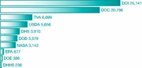
In FY 2006, more than 100,000 individual metadata records were available via geodata.gov, a 30-percent increase from the previous year. Key Federal metadata holdings are shown in the Metadata Records figure. On a regular basis, as additional metadata collections are discovered, they are added to the Network.
Metadata Records in Geospatial One-Stop Portal by Federal Agency (as of October 2006)
Note: Abbreviations are defined in the glossary in Appendix D.
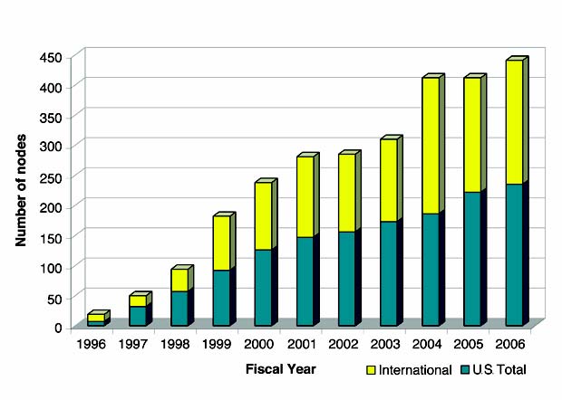
The number of registered collections, or “nodes,” within the NSDI Clearinghouse Network continues to grow, as shown in the NSDI Clearinghouse Growth figure. An effort to integrate the NSDI registry of metadata servers using the Z39.50 protocol with the geodata.gov portal list of services is under way. This effort will yield a consolidated set of registered services to be made available to the public in FY 2007.
NSDI Clearinghouse Growth by Year

The Global Clearinghouse Growth figure shows the number and relative percentage of registered metadata collections, primarily supporting the Z39.50 search and retrieval protocol worldwide. The number of collections continues to grow gradually both nationally and internationally.
Global Clearinghouse Growth by Year
Geospatial One-Stop Partnership Marketplace
The GOS Partnership Marketplace is an innovative capability of the geodata.gov portal where organizations can advertise their interest or intent in collecting geospatial data. By the end of FY 2006, the marketplace grew to include approximately 3,000 planned data acquisition records. From these 3,000 marketplace records, approximately 1,000 contacts were made regarding possible partnerships for data acquisition.
Standards Activities—Facilitating the Development and Sharing of Geospatial Data
Standards development is a critical factor in facilitating the development, sharing, and use of geospatial data. The FGDC develops geospatial data standards for implementing the NSDI, in consultation and cooperation with State, local, and tribal governments; the private sector and academic community; and, to the extent feasible, the international community.
The FGDC standards activity had several notable accomplishments in FY 2006:
- The FGDC Standards Working Group approved a proposal to develop the Wetlands Mapping Standard.
- The InterNational Committee for Information Technology Standards (INCITS) Technical Committee L1 approved Project 1574-D, Information Technology-Geographic Information Framework Data Content Standards (also known as the Framework Data Standard), for further processing to become an American National Standard (ANS). The draft Framework Data Standard was created to enable data exchange for seven fundamental geospatial themes of critical importance to the development of the NSDI.
- The FGDC endorsed the Digital Cartographic Standard for Geologic Map Symbolization.
- The FGDC’s Homeland Security Working Group developed a symbol set for emergency management and response. The effort resulted in the publication of American National Standards Institute (ANSI)/INCITS 415-2006, Homeland Security Mapping Standard—Point Symbology for Emergency Mapping in 2006.
- A systematic review of the FGDC standards program of work began in FY 2006. Reviews of FGDC standards endorsed for 5 years or more were conducted and recommendations were developed for further action.
New NSDI Training Materials Under Development
A new collection of NSDI Training Materials, which grew out of workshops held during 2006, is on the way. New training modules are being developed for Enterprise Architecture, Web Services, Spatial Data Infrastructure, Partnerships, Metadata, CAP, geodata.gov, Homeland Security Support, and Standards Integration. These training modules will greatly expand NSDI offerings.
A draft curriculum has been designed and inventories are being updated to reflect relevant training materials using a standardized database. Each module will have its own lesson plan. The current partner agencies in the NSDI training program are USGS/EROS, National Oceanic and Atmospheric Administration Coastal Services Center, National Park Service, U.S. Fish & Wildlife Service, Department of Homeland Security/Federal Emergency Management Agency, U.S. Department of Agriculture (USDA) Forest Service, and Environmental Protection Agency.
Developing the Street Address Standard
In FY 2006, the Address Standard Working Group (ASWG) closed the public comment period on the first draft of the standard, responded to all 149 comments received, revised the first draft extensively, posted the second draft for public comment, received close to 200 comments, and responded to all of them. In response, the ASWG has made substantial revisions to the second draft. The third draft of the standard will be presented to the FGDC Standards Working Group during the second quarter of FY 2007 for consideration for formal FGDC public review and adoption.
Advancing Imagery for the Nation
In FY 2006, the Imagery for the Nation (IFTN) initiative came closer to being implemented. The National Digital Orthophoto Programs (NDOP) Committee reviewed the initial IFTN proposal that was forwarded by the NSGIC to the FGDC. Part of this activity included developing Federal needs, identifying program costs, and resolving high-level issues related to the design of IFTN. Working as partners, USGS and USDA funded and contracted a cost-benefit analysis (CBA) study to be completed by June 2007. In addition to reporting Federal concerns, the CBA will include input from State and local governments and the private sector. In FY 2007, NDOP will work to improve the design of the IFTN initiative.
Success Stories
Ensuring Accurate Centerline and Boundary Data
Challenge: A critical need existed for more accurate road centerline data and for updated boundary data nationwide.
Action: The Census Bureau has a multiyear project to realign street features in the TIGER (Topologically Integrated Geographic Encoding and Referencing system) database to a minimum of 7.6 meters of horizontal positional accuracy, using State, tribal, county, and local files, wherever possible. More than 1,800 of these files have been used to date. Local hydrography or the National Hydrographic Dataset is used where it is available at medium or higher resolution.
Result: All agencies, local governments, and private individuals have free and clear access to accurate road centerline data and geographic boundary data that is in the public domain and freely downloadable from the Census Bureau’s Web site at www.census.gov.
Developing a Metadata Mining Tool
Challenge: More effective and efficient ways of developing metadata files were needed.
Action: The U.S. Department of Agriculture Forest Service developed a tool that works within ArcGIS, an integrated collection of GIS software, to populate certain components of standard metadata in an automated fashion.
Result: Version 1 of the Metadata Mining Tool is undergoing pilot testing in the Forest Service’s Alaska region.
Defining Digital Maritime Zones
Challenge: Digital maritime zones were needed to facilitate more precise enforcement, ocean governance, fisheries management, and marine transportation.
Action: The National Oceanic and Atmospheric Administration (NOAA) Office of Coast Survey, as a member of the ad hoc Committee on the U.S. Baseline, began work to create and distribute legal, digital maritime limits and a national baseline for the coastal United States. To establish these limits, the Office of Coast Survey is working with representatives of the Minerals Management Service of the Department of the Interior and with the Department of State to coordinate and combine expertise. This coordination includes an exchange of source data, technical and legal expertise, and training to ensure that the limits meet international standards.
Result: Digital limits and a national baseline for the Hawaiian Islands, Puerto Rico, U.S. Virgin Islands, and the continental United States have been completed and posted to the Internet. Creation of digital limits and a national baseline for Alaska and the U.S. island territories are under way and will be complete by the end of fiscal year 2007.
Facilitating Data Sharing To Help Southwest Border Communities
Challenge: Lack of adequate information on unincorporated border communities, known as colonias, along the Southwest U.S. border posed a challenge to researchers, policymakers, and citizens. Colonias lack adequate infrastructure and are characterized by substandard housing, poor health conditions, poverty, and, often, unregulated development. The Departments of Housing and Urban Development (HUD), Agriculture, and Health and Human Services and the Environmental Protection Agency needed better information to respond to the unique needs of colonias.
Action: Complementing work being done by the Office of the Attorney General and the Texas Water Development Board, HUD worked with the Department of Energy (DOE)/Oak Ridge National Laboratory and State and local entities to create consistent boundary files for colonias in Arizona, California, and New Mexico. Dynamic allocation methodologies, which can be reused for other purposes, were then designed and developed to assign census and other data to these non-Census boundaries.
Result: HUD, with assistance from the DOE, is creating a Web-enabled Southwest Border Colonia Research Database using open source public domain Internet technologies that will enable users to provide feedback, download boundary and data files, and query data about individual colonias. This resource will help better leverage resources, reduce duplication of effort, and facilitate data sharing across agencies.
1. Implement the Geospatial Line of Business
The Geospatial Line of Business (LoB) prepared and presented recommendations to the Office of Management and Budget (OMB) for approval. The release of the President’s fiscal year (FY) 2008 budget will officially launch the Geospatial LoB initiative for OMB, the Department of the Interior (DOI) and Federal Geographic Data Committee (FGDC) partner agencies.
A high-priority recommendation for the Geospatial LoB initiative includes establishing a Geospatial Program Management Office (GPMO). The GPMO will provide assistance to the FGDC Secretariat in support of the LoB and will be guided by the decisions of the FGDC Steering Committee. The GPMO will be responsible for task management, including activity development, contract management, deliverables management, and communications for the Geospatial LoB.
2. Establish the National Geospatial Advisory Committee
The FGDC is pursuing the establishment of a new advisory body, the National Geospatial Advisory Committee, in 2007. The committee will review and comment on geospatial policy and management issues and provide a forum to convey views representative of non-Federal Stakeholders in the geospatial community. The committee is being formed by DOI on behalf of FGDC partner agencies under the authority of the Federal Advisory Committee Act.
3. Expand the Fifty States Initiative
A minimum of 10 new National Spatial Data Infrastructure (NSDI) Cooperative Agreements Program grants will be issued in 2007. Additional Federal partnerships are being sought to support this initiative. By the end of FY 2007, approximately 28 States are expected to have received funding for strategic and business planning activities.
4. Expand International Collaboration and Leadership
The FGDC will continue programmatic involvement and support for the Global Spatial Data Infrastructure (GSDI) by contributing resources to the GSDI Small Grants Program and regional electronic newsletters, serve as members of the GSDI board, and providing support for developing comprehensive Spatial Data Infrastructure technical programs for the GSDI meetings, conferences, and workshops.
The Group on Earth Observations (GEO) and its Global Earth Observation System of Systems (GEOSS) embarked on an implementation phase for the FY 2007–09 work plan. The FGDC Secretariat and a number of U.S. Federal agencies are contributing to several of the committees through a U.S. GEO coordination effort.
The FGDC will collaborate on an interagency project of common geographic and topical interest that will exercise a number of interoperability standards in support of common research goals. This project supports other international activities, including the International Polar Year and GEO/GEOSS.
5. Increase the Value of the Geospatial One-Stop Portal
Increase Local Government Capacity
Because OMB Circular A-16 recognizes the importance of high-accuracy geospatial data sets created by towns, cities, counties, and regional programs throughout the country, the FGDC is increasing its outreach in FY 2007 to local governments to support development of the NSDI through the Geospatial One-Stop (GOS) program. A focal point of this outreach is reestablishing close working relationships with organizations such as the National Association of Counties, National Association of Regional Councils, National League of Cities, and various professional associations, including Urban and Regional Information Systems Association and Geospatial Information and Technology Association. Increased participation with Geographic Information System (GIS) software user groups is also planned. Local government outreach has set a goal of registering 30 to 40 local government Web mapping services to the GOS portal each quarter in 2007.
Enhance the Portal
In the continuing effort to make geospatial data easier to find and use to support decisionmaking across government, several enhancements to the GOS portal, www.geodata.gov, are planned for FY 2007. They will be implemented in three development cycles or releases and will improve the publishing functions, improve the geographic search for metadata, update the map viewer, and provide additional capabilities.
6. Advance Development and Acceptance of Standards
Framework Data Standard
The International Committee for Information Technology Standards (INCITS) Technical Committee L1, GIS, voted to approve the draft revised Framework Data Standard and adjudication of comments received with the previous INCITS L1 ballot. The draft standard and supporting documentation will be submitted to the INCITS Secretariat for further processing to become approved as an American National Standard (ANS) in 2007.
FGDC Standards
The following drafts will be submitted for FGDC public review in FY 2007:
- Street Address Standard
- Shoreline Data Content Standard
- Revised National Vegetation Classification Standard
- Wetlands Mapping Standard
- Trails Data Standard
Online Training for Standards
Framework implementation activities will move forward as the Wyoming Geographic Science Information Center continues developing framework training modules in FY 2007.
In 2007, a survey of framework implementation will be conducted in academic institutions to provide content for a white paper on framework implementation. The Framework Hydrographic Data Standard module will be completed and posted to an FGDC-sponsored site.
ISO 19115 Geospatial Information: Metadata—North American Profile
The draft North American Profile (NAP) is scheduled for release to INCITS L1 in 2007 for comment and ballot. After the draft NAP passes the INCITS L1 ballot, the document will be submitted to the INCITS Secretariat for further processing to become approved as an ANS.
An ISO metadata tool review by volunteers from the FGDC Metadata Working Group will be finalized during the spring of 2007. Tool review results will be posted to the FGDC metadata Web site.
7. Advance Imagery for the Nation Initiative
Three major objectives were outlined to advance the Imagery for the Nation (IFTN) initiative.
- Complete a cost-benefit analysis of the IFTN initiative to comprehensively review and determine the expected return on investment and develop a better understanding of the associated tangible and intangible benefits and risks.
- Develop and communicate a detailed analysis of the governance requirements, partnership opportunities, and contracting options related to State and Federal interactions on the implementation of IFTN.
- Develop strategies and options for funding a viable IFTN program in the FY 2009 budget.

Lynn Scarlett
Deputy Secretary
U.S. Department of the Interior
Chair, FGDC Steering Committee
Lynn Scarlett previously served as Assistant Secretary for Policy, Management and Budget at the Department of the Interior and previously chaired the Federal Wildland Fire Leadership Council, an interagency and intergovernmental forum for implementing the National Fire Plan and 10-Year Implementation Plan. She earned Bachelor of Arts and Master of Arts degrees in political science from the University of California, Santa Barbara.

Karen S. Evans
Administrator of Electronic Government and Information Technology
Office of Management and Budget
Vice Chair, FGDC Steering Committee
Karen S. Evans previously served as Chief Information Officer for the U.S. Department of Energy. She earned a bachelor’s degree in chemistry and a Master of Business Administration degree from West Virginia University.

Ivan B. DeLoatch
Staff Director
Federal Geographic Data Committee
Ivan B. DeLoatch provides leadership and management for FGDC operations and activities and serves as managing partner for the Geospatial Line of Business. He previously served as chief of the Data Acquisition Branch in the U.S. Environmental Protection Agency’s Office of Environmental Information. He earned a Bachelor of Science degree with a major in biology and a minor in chemistry from Bowie State University.
Exhibit 1. Steering Committee Members
Note: Membership through September 30, 2006. Membership on the Steering Committee changes periodically. For the latest membership list and contact information, visit the Federal Geographic Data Committee (FGDC) Web site, www.fgdc.gov.
Chair: Lynn Scarlett, Deputy Secretary, Department of the Interior
Vice Chair: Karen S. Evans, Administrator of Electronic Government and Information Technology, Office of Management and Budget
Federal Members
|
Department of Agriculture
|
www.usda.gov
|
Dave Combs
|
|
Department of Commerce
|
www.commerce.gov
|
Barry West
|
|
Department of Defense
|
www.defenselink.mil
|
Donald Basham, James Jancaitis
|
|
Department of Education
|
www.ed.gov
|
Mark Schneider
|
|
Department of Energy
|
www.doe.gov
|
Tom Pyke
|
|
Department of Health and Human Services
|
www.dhhs.gov
|
Charles Havekost
|
|
Department of Homeland Security
|
www.dhs.gov
|
Scott Charbo
|
|
Department of Housing and Urban Development
|
www.hud.gov
|
Darlene Williams
|
|
Department of the Interior
|
www.doi.gov
|
Mark Limbaugh
|
|
Department of Justice
|
www.usdoj.gov
|
Vance Hitch
|
|
Department of Labor
|
www.dol.gov
|
Patrick Pizzella
|
|
Department of State
|
www.state.gov
|
Susan Swart
|
|
Department of Transportation
|
www.dot.gov
|
John Bobo
|
|
Department of the Treasury
|
www.treasury.gov
|
Richard Holcomb
|
|
Department of Veterans Affairs
|
www.va.gov
|
Patrick Dunne
|
|
Environmental Protection Agency
|
www.epa.gov
|
Linda Travers
|
|
Federal Communications Commission
|
www.fcc.gov
|
Julius Knapp
|
|
General Services Administration
|
www.gsa.gov
|
Diane Herdt
|
|
Library of Congress
|
www.loc.gov
|
John Hebert
|
|
National Aeronautics and Space Administration
|
www.nasa.gov
|
Myra Bambacus
|
|
National Archives and Records Administration
|
www.archives.gov
|
Michael Kurtz
|
|
National Science Foundation
|
www.nsf.gov
|
Margaret Leinen
|
|
Nuclear Regulatory Commission
|
www.nrc.gov
|
Jacqueline Silber
|
|
Office of Personnel Management
|
www.opm.gov
|
Janet Barnes
|
|
Small Business Administration
|
www.sba.gov
|
Michael McHale
|
|
Smithsonian Institution
|
www.si.edu
|
Dennis Shaw
|
|
Social Security Administration
|
www.socialsecurity.gov
|
Edward DeMarco
|
|
Tennessee Valley Authority
|
www.tva.gov
|
Alan Voss
|
|
U.S. Agency for International Development
|
www.usaid.gov
|
Michael Hess
|
Exhibit 2. Non-Federal Collaborating Partners
Note: Membership through September 30, 2006.
Non-Federal Collaborating Partners
|
American Congress on Surveying and Mapping
|
www.acsm.net
|
Rebecca Somers
|
|
Association of American Geographers
|
www.aag.org
|
Douglas Richardson
|
|
Cartographic Users Advisory Council
|
www.cuac.wustl.edu
|
Linda Zellmer
|
|
Geospatial Information and Technology Association
|
www.gita.org
|
Bob Samborski
|
|
International City/County Management Association
|
www.icma.org
|
Eric Anderson
|
|
National Association of Counties
|
www.naco.org
|
Randy Johnson
|
|
National Association of State Chief Information Officers
|
www.nascio.org
|
Tom Jarrett
|
|
National League of Cities
|
www.nlc.org
|
Donald Borut
|
|
National States Geographic Information Council
|
www.nsgic.org
|
Stu Davis, Bill Burgess
|
|
Open Geospatial Consortium, Inc.®
|
www.opengeospatial.org
|
Mark E. Reichardt
|
|
University Consortium for Geographic Information Science
|
www.ucgis.org
|
Allan Falconer
|
|
Urban and Regional Information Systems Association
|
www.urisa.org
|
Wendy Francis
|
|
Western Governors’ Association
|
www.westgov.org
|
Dennis Goreham
|
Exhibit 3. Secretariat Staff Members
Note: The organization of staff members is dynamic. For the latest staff list and contact information, visit the FGDC Web site, www.fgdc.gov.
Secretariat Staff
|
Position
|
Name
|
|
Staff Director
|
Ivan DeLoatch
|
|
Deputy Staff Director
|
Leslie Armstrong
|
|
Program Assistant
|
Carol Greenough
|
|
Technology Advisor/Information Architect
|
Doug Nebert
|
|
FGDC Interagency Liaison
|
Alison Dishman
|
|
FGDC and GSDI International Program Coordinator
|
Alan Stevens
|
|
Framework and Cooperating States Coordinator
|
Milo Robinson
|
|
Associate Strategist
|
Kathy Covert
|
|
Metadata Coordinator
|
Sharon Shin
|
|
NSDI CAP Coordinator
|
Brigitta Urban-Mathieux
|
|
Standards Program Manager
|
Billy Tolar
|
|
Standards Coordinator
|
Julie Maitra
|
|
Training and Education/Tribal Liaison Coordinator
|
Bonnie Gallahan
|
|
Information Systems Specialist
|
Donna Scholz
|
|
Secretary
|
Arista Salimi
|
|
Webmaster
|
Vaishal Sheth
|
|
Line-of-Business Coordinator
|
Roxanne Lamb
|
Note: Abbreviations are defined in the glossary in Appendix D.
Appendix C. Status of NSDI Framework Data Themes
National Spatial Data Infrastructure (NSDI) recognizes that geospatial applications of many different disciplines have a recurring need for a few themes of data—the NSDI framework. Local, regional, State, and Federal government organizations and private companies perceive the framework as a means for sharing resources, improving communication, and increasing efficiency. The framework’s seven data themes are geodetic control, orthoimagery, elevation, transportation, hydrography, governmental units, and cadastral information. The framework is one of the key building blocks of the NSDI and forms the NSDI’s data backbone.
Data Theme: Cadastral
Responsible agency: U.S. Department of the Interior, Bureau of Land Management (BLM)
The BLM manages cadastral data by storing it in the National Integrated Land System (NILS), which is a joint project between the BLM, U.S. Department of Agriculture (USDA) Forest Service, and State, county, and private organizations. The BLM provides the central database, technical development, distribution, data integration, leadership, program management, coordination, and maintenance for NILS. In fiscal year (FY) 2006, new functionality was added to NILS, including the capability to import and export cadastral data in various file formats. BLM and USDA Forest Service cadastral experts evaluated the Measurement Management functionality, resulting in improvements to the least square adjustment tools for determining the best coordinate locations and point alias tools for resolving township boundary differences.
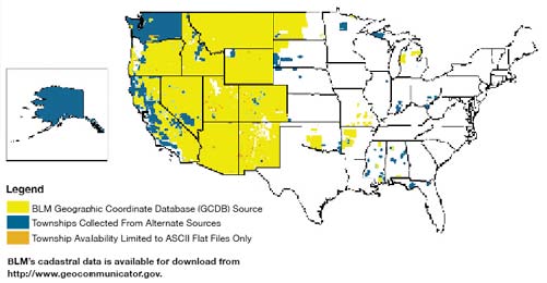
Data Theme: Cadastral (Offshore)
Responsible agency: U.S. Department of the Interior, Minerals Management Service (MMS)
These maps show the MMS planning areas for the Offshore Cadastral A-16 data theme. Data for the 2007–12 Oil and Gas Leasing program are available for all planning areas shown on these maps.
Planning Areas Map
This map depicts the MMS planning areas for the Outer Continental Shelf (OCS) for the continental United States.

Alaska Planning Areas Map
This topographic map shows all MMS planning areas and major rivers in Alaska.

Gulf of Mexico Map
This map shows the Gulf of Mexico region. The red areas are MMS planning areas and the lease blocks are shown inside. The lighter colored blocks indicate active leases. The black objects are oil-related facilities, such as drilling rigs.

Data Theme: Digital Ortho Imagery
Responsible agencies: U.S. Department of the Interior, U.S. Geological Survey (USGS) and U.S. Department of Agriculture (USDA), Farm Service Agency (FSA)
The USGS is the Federal lead for orthoimagery; however, a number of Federal agencies—Bureau of Land Management, Federal Emergency Management Agency (FEMA), National Oceanic and Atmospheric Administration (NOAA), U.S. Census Bureau, and USDA’s FSA and Natural Resources Conservation Service—and the National States Geographic Information Council cooperate in the National Digital Orthophoto Programs (NDOP) consortium to develop and maintain national orthoimagery coverage in the public domain. The primary Federal programs for NDOP are the USDA National Agriculture Imagery Program (NAIP) and USGS National Orthoimagery Program.
USGS National Orthoimagery Program
The USGS National Orthoimagery Program concentrates on the following four areas:
- Urban areas in the Homeland Security Infrastructure Program.
- High-resolution States (better than 1-meter resolution).
- Medium-resolution States (leaf-off)
- Medium-resolution States (leaf-on) in the NAIP.
In FY 2006, the orthoimagery acquisition program included 57 partnerships with counties and cities and 24 partnerships with States and regional consortia that were contracted through the USGS regional offices. Current orthoimagery was acquired for the Gulf Coast and southeast Atlantic Coast in preparation for the 2006 hurricane season. A rapid response delivery system was initiated as a pilot project to house the coastal imagery, but it was not sufficiently tested because of the mild hurricane season in 2006.
Multiple Resolution Orthoimagery Acquisition Cycle, October 2006
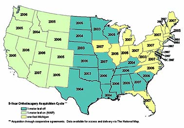
The USDA National Agriculture Imagery Program
NAIP combines innovative program management, technology integration, and contract administration to acquire 1- and 2-meter resolution natural color imagery during the growing season. NAIP’s strategy is to annually acquire 1-meter imagery over roughly 20 percent of the Nation to meet a 5-year base imagery replacement schedule and collect 2-meter imagery over the remaining agricultural lands in the continental United States for farm program administration and compliance activities. The program established an unprecedented expedited product delivery process, distributing compressed county mosaics 30 days after the flying season ends and Digital Orthophoto Quarter Quadrangles within the following year.
In FY 2006, with partnership contributions totaling more than $7 million dollars, FSA acquired 1-meter imagery in 13 States and 2-meter coverage of agriculture lands over the rest of the continental United States. Contingent on funding availability, in FY 2007 NAIP has scheduled 7 States for 1-meter imagery collection and plans to acquire 2-meter imagery over agricultural lands in 41 States.
National Agriculture Imagery Program, 2006 Contracted Coverage

National Agriculture Imagery Program, Cycle 2 (2008–12), Proposed 5-year, 1-meter Cycle

National Agriculture Imagery Program, Cycle 1 (2003–07), is available from http://www.fsa.usda.gov/Internet/FSA_File/naip_cycle1pdf.pdf.
Data Theme: Elevation Terrestrial
Responsible agency: U.S. Department of the Interior, U.S. Geological Survey (USGS)
The National Elevation Dataset (NED) contains elevation data, which provide three-dimensional surface models of the Earth’s surface. USGS makes elevation data available both for land areas, and, in cooperation with the NOAA, under coastal waters. USGS identifies digital elevation data based on the resolution (spacing between the points) of the grid. One arc-second (equivalent to 30-meter) posted elevation data are complete and available for the entire United States. Current USGS efforts concentrate on providing finer resolution of elevation data at 1/3- and 1/9-arc-second (equivalent to 10- and 3-meter, respectively) post spacing. The data are developed from a variety of sources, including State and local governments and the private sector.
The elevation theme includes best available data from Federal, State, local, and private-sector partners. The USGS plans to continue working closely with FEMA to incorporate elevation data acquired through that agency’s flood plain map modernization program and to continue the program of exchanging elevation data with the USDA Forest Service. The USGS anticipates incorporating 1/9 arc-second data acquired by other Federal agencies over urban areas into the NED. The data are organized to provide ease of use for customers to define the area for data they wish to access.
National Elevation Dataset, September 27, 2006
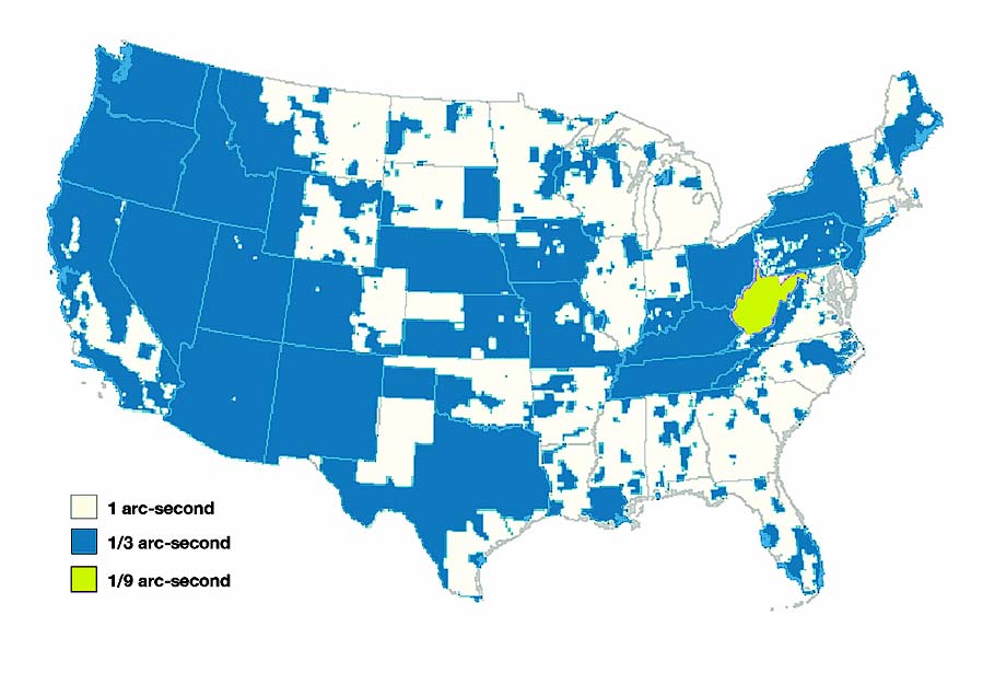
Data Theme: Elevation Bathymetry
Responsible agency: U.S. Department of Commerce (DOC), National Oceanic and Atmospheric Administration (NOAA), National Ocean Service, Office of Coast Survey
NOAA, as the officially recognized charting agency in the United States, is responsible for conducting hydrographic surveys. The one data type common to all hydrographic surveys is water depth. Of additional concern to most surveys is the nature of the sea floor material (e.g., sand, mud, rock) due to its implications for anchoring, dredging, structure construction, pipeline and cable routing, and fisheries habitat. The primary use of hydrographic surveys is nautical charting. This application requires the precise location of least depths on dangers to navigation and depths significant to surface navigation. The precise location of aids to navigation is also required.
Graphics showing the status of the bathymetry layer of the NSDI are on the NOAA Office of Coast Survey Web page at http://chartmaker.ncd.noaa.gov/staff/NHSP.html.
National Ocean Service Hydrographic Survey Projects, 2006

Data Theme: Geodetic Control
Continuously Operating Reference Stations
Responsible agency: U.S. Department of Commerce, National Oceanic and Atmospheric Administration (NOAA), National Geodetic Survey
NOAA’s National Geodetic Survey (NGS) works in partnership with 120 Federal, State, and local agencies and with academia and private organizations to provide Global Positioning System data from the Continuously Operating Reference Stations (CORS) national network.
The CORS network supports high-accuracy positioning activities and forms the backbone of the National Spatial Reference System, which provides the foundation for transportation and communication, mapping and charting, and a multitude of scientific and engineering applications. In FY 2007, NGS plans to complete the readjustment of the North American Datum of 1983 and to revitalize the Federal Geodetic Control Subcommittee. In FY 2006, NGS published and implemented new CORS guidelines and merged the Mexican CORS network with the U.S. National CORS network.
CORS National Network
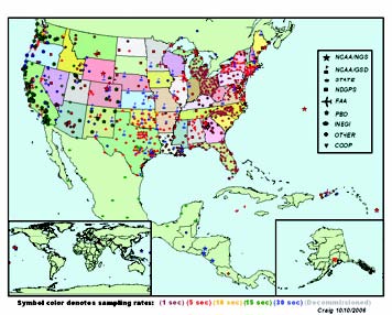
Data Theme: Hydrography
Responsible Agency: U.S. Department of the Interior, U.S. Geological Survey (USGS)
These data make up the National Hydrography Dataset, which is a common data model and nationwide coverage of surface water features at 1:100,000 scale and 1:24,000 scale. These data were produced by a consortium of more than 50 government agencies at the Federal and State levels to provide a universal solution for hydrography across the Nation. The USGS provides the central database, technical development, distribution, data integration, leadership, program management, coordination, and continuous maintenance through stewardship partnerships with the user community.
Status of the High-resolution National Hydrography Dataset, September 25, 2006
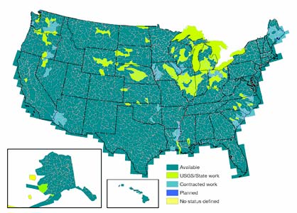
Appendix D. Glossary of Abbreviations and Terms
|
AAG |
Association of American Geographers |
|
ACSM |
American Congress on Surveying and Mapping |
|
ACWI |
Advisory Committee on Water Information |
|
ANS |
American National Standard |
|
ANSI |
American National Standards Institute |
|
APHIS |
Animal and Plant Health Inspection Service |
|
ASWG |
Address Standard Working Group |
|
BLM |
Bureau of Land Management |
|
BRD |
Biological Resources Discipline |
|
BTS |
Bureau of Transportation Statistics |
|
CAP |
Cooperative Agreements Program |
|
CBA |
cost-benefit analysis |
|
CIO |
Chief Information Officer |
|
COP |
community of practice |
|
CORS |
Continuously Operating Reference Stations |
|
CUAC |
Cartographic Users Advisory Council |
|
DHHS |
U.S. Department of Health and Human Services |
|
DHS |
U.S. Department of Homeland Security |
|
DOC |
U.S. Department of Commerce |
|
DoD |
U.S. Department of Defense |
|
DOE |
U.S. Department of Energy |
|
DOI |
U.S. Department of the Interior |
|
DOT |
U.S. Department of Transportation |
|
EPA |
U.S. Environmental Protection Agency |
|
FEA |
Federal Enterprise Architecture |
|
FEMA |
Federal Emergency Management Agency |
|
FGDC |
Federal Geographic Data Committee |
|
FSA |
Farm Service Agency |
|
FY |
fiscal year |
|
GEO |
Group on Earth Observations |
|
GEOSS |
Global Earth Observation System of Systems |
|
GIS |
Geographic Information System |
|
GITA |
Geospatial Information & Technology Association |
|
GOS |
Geospatial One-Stop |
|
GPMO |
Geospatial Program Management Office |
|
GSDI |
Global Spatial Data Infrastructure |
|
HUD |
U.S. Department of Housing and Urban Development |
|
ICMA |
International City/County Management Association |
|
IFTN |
Imagery for the Nation |
|
INCITS |
International Committee for Information Technology Standards |
|
LoB |
Line of Business |
|
MMS |
Minerals Management Service |
|
MODIS |
Moderate Resolution Imaging Spectroradiometer |
|
NACo |
National Association of Counties |
|
NAIP |
National Agriculture Imagery Program |
|
NAP |
North American Profile |
|
NARA |
National Archives and Records Administration |
|
NASA |
National Aeronautics and Space Administration |
|
NASCIO |
National Association of State Chief Information Officers |
|
NDOP |
National Digital Orthophoto Programs |
|
NED |
National Elevation Dataset |
|
NGA |
National Geospatial-Intelligence Agency |
|
NGAC |
National Geospatial Advisory Committee |
|
NGS |
National Geodetic Survey |
|
NILS |
National Integrated Land System |
|
NLC |
National League of Cities |
|
NOAA |
National Oceanic and Atmospheric Administration |
|
NRCS |
Natural Resources Conservation Service |
|
NSDI |
National Spatial Data Infrastructure |
|
NSGIC |
National States Geographic Information Council |
|
OMB |
Office of Management and Budget |
|
PD&R |
Office of Policy Development and Research |
|
TEOC |
Transmission Emergency Operations Center |
|
TIGER |
Topologically Integrated Geographic Encoding and Referencing system |
|
TVA |
Tennessee Valley Authority |
|
UCGIS |
University Consortium for Geographic Information Science |
|
URISA |
Urban and Regional Information Systems Association |
|
USCB |
U.S. Census Bureau |
|
USDA |
U.S. Department of Agriculture |
|
USFWS |
U.S. Fish & Wildlife Service |
|
USGS |
U.S. Geological Survey |

