Contents
National Spatial Data Infrastructure Champion
FGDC Goals for Fiscal Year 2011
Appendix A. FGDC Leadership Profiles
Appendix B. FGDC Structure and Membership
Appendix C. Status of NSDI Data Themes
Appendix D. Glossary of Abbreviations and Terms
2010 has been a year of continued accomplishment and progress for the Federal Geographic Data Committee (FGDC), with significant advances in the collaborative development of geospatial data and technology. The theme of this year’s annual report from the FGDC is “The Geospatial Platform.” The Geospatial Platform is a new collaborative concept that was described in the President’s fiscal year 2011 budget:
- “In 2010 and 2011, Federal data managers for geospatial data will move to a portfolio management approach, creating a Geospatial Platform to support Geospatial One-Stop, place-based initiatives, and other potential future programs.”
The Geospatial Platform will be an accessible, reliable, and
cost-effective collection of data, tools, and services that will
provide a capability to help address the Administration’s priorities
for data sharing, transparency, and collaboration. The Geospatial
Platform will be developed based upon the principles of collaborative
governance, partnerships, shared infrastructure, and collecting data
once and using it many times. The FGDC Executive Committee has taken a
leadership role in developing an initial roadmap for the Geospatial
Platform and laying the foundation for integrated non-Federal
governance and public/private partnerships. We look forward to moving
toward further development and implementation of this promising new
initiative in 2011.
The FGDC has provided important support for key Administration
initiatives. For example, the Data.gov portal, which is the
Administration’s flagship data initiative, celebrated its first
anniversary in 2010. During the course of the year, datasets accessible
though Data.gov increased from 1,400 to over 270,000. Over 90 percent
of these 270,000 datasets are geospatial data. This tremendous growth
was facilitated and made possible through a dedicated and concerted
effort by many geospatial specialists within the FGDC partner
agencies.
Several other important developments have also taken place during the
past year. For example, the FGDC Steering Committee approved new
Supplemental Guidance to the Office of Management and Budget’s Circular
A–16, which will provide a more effective process to manage Federal
geospatial investments utilizing portfolio management. The FGDC also
made progress on several new data standards, including the United
States Thoroughfare, Landmark, and Postal Address Data Standard and the
Coastal and Marine Ecological Classification Standard. The FGDC is also
developing a new business case for the Imagery for the Nation
initiative and has approved the National Digital Orthoimagery Program
(NDOP) Subcommittee as a new FGDC subcommittee.
Fiscal year 2011 will focus on continued collaboration to better
enable public-private partnerships and investments, and continued
progress on the development of geospatial data and tools for the
benefit of the agencies and the public we serve.

National Spatial Data Infrastructure Champion

Dr. Jerry J. Johnston
Champions are leaders. They are dedicated to achieving
success. They lead by example and personify a “can do” attitude.
Leaders are visionary in their approach, efficient in their execution,
and valued for their outcomes. The tools they use—innovation,
cooperation, and mitigation—are keys to success. Each year the FGDC
recognizes as a champion one who has taken a strong leadership role in
the development of the National Spatial Data Infrastructure (NSDI).
This year’s honoree is Dr. Jerry J. Johnston.
Dr. Johnston’s leadership is clearly reflected by his key
contributions to the operations of the FGDC Steering Committee, the
Executive Committee, and the National Geospatial Advisory Committee
where he provided strategic leadership and applied a multifaceted
approach to coordination. His ability to provide visionary direction to
geospatial coordination while also applying a “roll-up-the-sleeves”
approach to integrating geospatial data into Data.gov has helped
advance key geospatial initiatives such as the Geospatial Platform. Dr.
Johnston’s efforts with Data.gov, a primary Administration priority,
(1) ensured that geospatial data was integrated into the Data.gov
framework, (2) brought geospatial data into the mainstream limelight,
and ultimately (3) enabled Data.gov to exceed its anniversary service
goal of 250,000 available data records. As of July 2010, over 90
percent of the records available through Data.gov are geospatial. For
his vision, dedication, tireless efforts, and successful leadership in
the NSDI community, Dr. Johnston is recognized as this year’s NSDI
Champion.
Biography
Dr. Jerry J. Johnston is the Geographic Information Officer for the U.S. Environmental Protection Agency (EPA). In this role he is responsible for leading efforts to implement enterprise geospatial services and technologies that support achieving the diverse mission goals of the Agency. He is an active member in several Federal geographic coordinating committees. Through his leadership in interagency programs Dr. Johnston led the design, development, and release of the Data.gov GEO Viewer application and the development for mapping components of the interagency ChesapeakeStat application. Dr. Johnston received the Federal Computing Week Fed100 award in recognition of information technology innovation for his efforts within the EPA. Prior to joining the EPA in 2005, Dr. Johnston conducted research on complex environmental systems modeling and served as the project manager for numerous geospatial projects in the private sector. Dr. Johnston is a graduate of Michigan State University and Indiana University where he received degrees in environmental science.
1. Geospatial Platform
The President’s fiscal year 2011 budget called for the establishment of a Geospatial Platform that supports Geospatial One-Stop, place-based initiatives, and other potential and future programs. This direction, along with the 2011 and 2010 memos on Place-Based Policy, and integration of geospatial capabilities into Recovery.gov and Data.gov, reflects the value the Administration sees in geospatial information, and recognizes the need to leverage the large Federal investment in geospatial data. In fiscal year 2010, the foundational framework for the Geospatial Platform was defined and laid out in the “Modernization Roadmap for the Geospatial Platform” document. Developed under the leadership of the FGDC Executive Committee, with participation and feedback from Federal and non-Federal sources, the Roadmap defines the path forward for implementing common geospatial data, services, and applications for meeting Federal Government and non-Federal government business requirements. The Geospatial Platform will leverage the efforts of the Geospatial Line of Business activities. Additionally, the GeoPlatform.gov Web portal was established utilizing a NOAA hosted Gulf Response application that was featured on a major newscast. For more information click here.
2. Data.gov
Data.gov celebrated its one-year anniversary in May 2010. During the first year, Data.gov expanded its accessible raw data from 47 records to 272,677 records, exceeding the first-year target of a quarter-of-a-million records. The Federal geospatial community played a critical role in enabling this success. Of the available records, 270,724 are geospatial data or over 90 percent of the data. Late in fiscal year 2010, Data.gov unveiled its first geospatial visualization capability, GEO Viewer, an interactive mapping tool designed to let users preview geospatial data available through the Data.gov catalog. For more information click here.
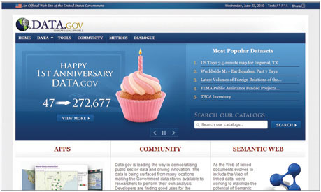
Graphic showing Data.gov home page on its first anniversary.
3. Geospatial One-Stop
In fiscal year 2010, the Geospatial One-Stop (GOS) project focused on integration with the new Administration’s Open Government Initiative through Data.gov. Connectivity between GOS and Data.gov takes place using newly developed GOS Web service capabilities that enable searches for geospatial data through applications beyond the GOS portal. During fiscal year 2010, the GOS data collection grew to over 430,000 records, of which over 270,000 are shared through Data.gov. In addition, GOS as a Web service was used in the development of several applications by four NSDI Cooperative Agreements Program awards. For more information click here.
4. Geospatial Line of Business
The Geospatial Line of Business (Geospatial LoB) has served as the policy, planning, and key business processes component for the geospatial information community. During the past year, the work groups advanced the Geospatial SmartBUY Agreement, which lowers the cost of doing business and improves access to geospatial technologies, saving the Federal Government over $8 million in the first three quarters alone. The work groups finalized the Office of Management and Budget Circular A–16 Supplemental Guidance, which improves the coordination and use of spatial data by utilizing a portfolio management approach for geospatial data management and reporting. Likewise, key steps were made to advance the development of the geospatial segment architecture that defines a framework for shared infrastructure. These work group efforts and others were refined to align with direction in the President’s budget in order to provide a foundation for the Geospatial Platform and help to guide its implementation strategy. For more information click here.
5. National Geospatial Advisory Committee
The National Geospatial Advisory Committee (NGAC) was established by the Department of the Interior to provide external advice and recommendations to the FGDC. During the past year, the NGAC analyzed and provided feedback and recommendations on the new Geospatial Platform Initiative, the economic recovery bill, national geospatial policy approaches, and metrics for geospatial programs. For more information click here.
6. Fifty States Initiative
In 2010, the Fifty States Initiative celebrated its 5-year anniversary, recognizing five years of improving geospatial coordination through strategic and business planning. Ten new Cooperative Agreements Program awards were made to support collaborative planning and a kickoff meeting was held in March 2010. Forty-five States plus the District of Columbia and the Virgin Islands have received over $2.4 million since the initiative started. The Initiative advances ways to measure progress on geospatial coordination. In particular, FGDC supports efforts to develop a Geospatial Maturity Assessment model and is continuing to assess progress of the Initiative. For more information click here.
7. International Activities
The FGDC continues its international activities through participation in international standards organizations (ISO/TC 211) and the Open Geospatial Consortium and support of the Global Spatial Data Infrastructure (GSDI) biennial conference, the GSDI Small Grants Program, and the intergovernmental Group on Earth Observations (GEO), as well as its Global Earth Observation System of Systems (GEOSS). For more information click here.
8. Standards
In fiscal year 2010, the FGDC released the draft United States Thoroughfare, Landmark, and Postal Address Data Standard and the draft Coastal and Marine Ecological Classification Standard for public review and comment. Both standards were the result of rigorous development processes prior to submission of the committee draft for public review. The FGDC initiated a process to endorse external standards in support of the Geospatial Platform. The FGDC also conducted an online survey on the FGDC standards process. Survey participants commented on the length of time it takes to develop standards and identified reasonable lengths of time to accomplish steps in the FGDC standards process. For more information click here.
9. Imagery for the Nation
The Imagery for the Nation (IFTN) Phase 1 Project was initiated late in fiscal year 2008 to explore the development of a Federal program, conducted in partnership with State and local governments, to address the Nation’s basic business needs for imagery at 1-meter resolution and higher. Building on the foundation of the Phase 1 Project conducted in fiscal year 2009, the FGDC Executive Committee and the Work Groups began development in fiscal year 2010 of a business case and funding request for IFTN. Led jointly by USDA and DOI, this process will document the justification for capital investment and plans for executing IFTN for review by the Office of Management and Budget (OMB). This is a first step to obtaining OMB approval for a budget request related to the information technology aspects of IFTN. For more information click here.
10. National Digital Orthoimagery Program Subcommittee
In September 2009, the FGDC Executive Committee unanimously endorsed a Record of Decision (ROD) proposed by the IFTN Planning Team. The ROD recommendations on IFTN governance included the following: “The National Digital Orthophotography Program, re-chartered as an FGDC subcommittee, will provide operational-level coordination of IFTN activities. [The subcommittee] will focus on coordination and management issues related to Federal imagery programs.” At its July 2010 meeting, the FGDC Coordination Group unanimously passed the proposed charter to establish the National Digital Orthoimagery Program (NDOP) subcommittee and recommended the NDOP’s establishment to the FGDC Steering Committee. Upon approval by the FGDC Steering Committee, the NDOP subcommittee will begin operations.
11. FGDC Coordination Group
In December 2009, the FGDC Coordination Group elected its first Co-Chair to serve with the Executive Director of the FGDC Secretariat. William Mullen, National Geospatial-Intelligence Agency, dutifully fulfilled this role. The Co-Chair role was established as part of revisions to the Coordination Group Charter, which now also has provisions for additional Federal members to be appointed by Federal senior agency officials. The additional Federal members support geospatial information for second-tier agencies within their departments, thus allowing second–tier agency members to represent their unique geospatial missions. For more information on membership click here.
12. Recovery.gov
The FGDC Executive Committee established a team in 2009 to work with the Recovery.gov development team to help ensure that the Web portal could leverage geospatial capabilities in the presentation of Federal investments in the American Recovery and Reinvestment Act (Recovery Act) funding data to the public. In 2010, this team of cross-agency geospatial experts provided valuable feedback and lessons learned to the Recovery.gov developers, including input on geocoding resources, user interface design, report use cases, and data feeds. The Recovery.gov site utilizes maps as the central organizing principle for presenting both agency and recipient information on (1) where recipient awards have been funded, by State, zip code, or neighborhood; (2) funding amount summaries; (3) recipient information; (4) project status; and (5) other parameters. Recovery.gov is a prime example of how geospatial information and spatial analysis adds value to other government data, and how maps and place-based approaches can help users interpret how and where Federal programs and activities are affecting their communities.
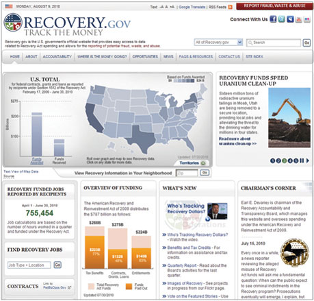
Graphic showing the home page for Recovery.gov.
| The American Recovery and Reinvestment Act (Recovery Act) of 2009 was a direct response by Congress and the President to the economic crisis. Its three immediate goals are to (1) create new jobs and save existing ones, (2) spur economic activity and investment in long-term growth, and (3) foster unprecedented levels of accountability and transparency in government spending. All recipients of Recovery funds are required to report quarterly on how they are using the money. These data are posted on Recovery.gov, the Web site required by the Recovery Act to “foster greater accountability and transparency in the use of funds made available by this Act.” |
13. National Land Parcel Data
The FGDC Subcommittee for Cadastral Data continued its efforts to create national land parcel data by providing updates to the existing national inventory of cadastral data and by identifying several State cadastral coordinators. In addition, three workgroups were established to address the various themes: the National Parcel Workgroup, the Federal Parcel Workgroup, and the Public Land Survey System (PLSS) and Common Control Workgroup. Also this year, the Cadastral Subcommittee completed an essential metadata profile. For more information click here.
|
Success Stories USGS Milestone Reached for Map Production Challenge: Through the second half of the 20th century, the U.S. Geological Survey (USGS) produced more than 60,000 paper topographic maps, providing complete coverage of the United States. The median publication date for these maps is 1979. As such, the existing legacy paper map collection is out of date and possibly not current enough for use by scientists, engineers, emergency responders, and the public, including recreational users. In response to the need for updated topographic maps, the USGS National Geospatial Program has developed and made available a new national map series called US Topo.
Action: These maps are modeled on the old topographic series, but are derived from the best available, existing government digital data, and are created semi-automatically using processes that will allow the entire contiguous United States to be remapped every 3 years. Production of these maps began in earnest in June 2009. In a little more than a year, the USGS National Geospatial Technical Operations Center has published more than 25,000 maps in the traditional 7.5-minute quadrangle format. This equates to more than 2,000 maps per month, or nearly 100 per workday. Instead of printing and distributing paper copies, the entire US Topo collection is available as digital files and is distributed for free, through the Web, via the USGS Store. Currently available US Topo maps and earlier “Digital Maps – Beta” are posted at nationalmap.gov/ustopo/.
Result: Although US Topo maps do not have the handcrafted, artistic appearance of the original, manually produced topographic maps, they do include high-resolution color aerial imagery that provides visible content not available in the original map series. Future project objectives include adding additional content, such as county boundaries and vegetation, while still achieving rigorous production goals. The rapid production cycle will soon eliminate the no-coverage and out-of-date map problems that are inherent in the original, paper map series.
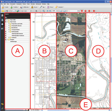
A portion of the US Topo map for Coffeyville, Kansas. New features allow the user to mix and match the information (using options in area (A) to create a topographic map (B), a topographic map with an image (C), selections of topographic map information such as only elevation and surface water (D), or other chosen combinations. Additional software provides a coordinate readout (E) that reports the location of the cursor in longitude and latitude and other coordinate systems. Other software tools are available that allow users to measure distances and areas and to use the map with the Global Positioning System.
|
The Geospatial Platform
![]()
“In 2010 and 2011, Federal data managers for geospatial
data will move to a portfolio management approach, creating a
Geospatial Platform to support Geospatial One-Stop, place-based
initiatives, and other potential future programs.
This transformation will be facilitated by improving the governance
framework to address the requirements of State, local and tribal
agencies, Administration policy, and agency mission objectives.
Investments will be prioritized based on business needs.
The Geospatial Platform will explore opportunities for increased
collaboration with Data.gov, with an emphasis on reuse of architectural
standards and technology, ultimately increasing access to geospatial
data.”
President’s Budget, Fiscal Year 2011
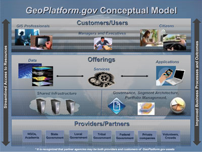
The Geospatial Platform Conceptual Model.
The Need for Geospatial Capabilities
The challenges this Nation will face in the upcoming decades
will be multifaceted and complicated; they will require diverse
information, innovative analysis, and new levels of collaboration to
solve. These issues and events have one other common
characteristic—they occur in places.
Consider some of the most devastating events in recent United States
history: the terrorist attacks on September 11, 2001; Hurricane
Katrina; the mortgage crisis; and the Deepwater Horizon oil spill in
the Gulf of Mexico. Responses to such events require coordination,
information sharing, analysis, and deployment of operational
capabilities, all of which are reliant on knowledge of place.
An example of complex questions raised by such events is evident in
the recent Gulf oil spill:
- How can we best observe, understand, track, and monitor the existing, pending, and future impacts of this event?
- Where do we mobilize and apply resources to provide the greatest good, prevent the greatest harm, and protect the life, health, and welfare of citizens?
- How do we synthesize vast information resources of the Federal, State, regional, local, and Tribal governments, the private sector, academia, and citizens to provide the on-the-ground situational awareness required to make wise decisions?
- How do we determine where proactive steps can be taken to prevent or minimize future impacts, such as identifying Gulf coastal communities where aid will be required?
- How do we measure our progress in cleaning up and recovering from the event?
In addition to responding to unforeseen events, the vast
majority of the day-to-day activities of government and citizens rely
on information linked to places and communities. Commuting to work,
choosing where to live and raise families, protecting our natural
resources, planning vacation destinations, and juggling busy schedules
all require knowledge about place to answer questions and solve
problems.
Using place as an information management framework allows decision
makers to leverage visualization techniques, government databases, and
geospatial analysis tools to rapidly recognize patterns in large
amounts of data and make more informed decisions. Displaying results
through interactive maps helps communicate complex ideas clearly. This
“place-based” framework is consistent with Administration priorities
for place-based policies and budgeting.
The Case for the Geospatial Platform
Geospatial data, tools, and resources are already an
integral part of many Federal, State, regional, local, and Tribal
government day-to-day operations. While the business needs of
stakeholders vary, different operations frequently require the use of
similar resources. Because geospatial information often involves a
significant financial investment, many governments coordinate their
efforts to produce cost savings, improve quality of services, and
increase efficiency, although clearly more could be done. Under the
basic premise “build it once, use it many times,” benefits already
realized through coordination can be enhanced and expanded when
implemented on a larger scale through the Geospatial Platform. The
Geospatial Platform will provide the means to enhance and expand these
capabilities by offering an operational focal point for delivering
trusted geospatial data, services, and applications that can be
accessed and used by multiple organizations.
The Geospatial Platform will promote efficient problem-solving tools
across organizations, thereby reducing the cost associated with
developing independent geospatial capabilities. The Geospatial Platform
will provide the environment and leadership needed to successfully
share geospatial data, services, and applications that support all
levels of government. It will promote information sharing across the
geospatial community and provide opportunities to view and conduct
business in new and innovative ways.
Building the Geospatial Platform
Coordinating the development and delivery of the Nation’s geospatial data and services is a complicated task, but the geospatial community has come together to create an initiative that does just that. The Geospatial Platform is the culmination of these efforts. The partner agencies of the Federal Geographic Data Committee and its stakeholders in government, academia, and the private sector are developing the foundational plans for the Geospatial Platform, which is a managed portfolio of common geospatial data, services, and applications hosted on a shared infrastructure and used by all sectors of society. Karen Siderelis from the Department of the Interior serves as the Platform’s Executive Sponsor and Tony LaVoi from National Oceanic and Atmospheric Administration serves as the initial Project Manager. Components of the Geospatial Platform include technical architecture, processes and organizational elements, and an implementation plan. The Geospatial Platform will leverage the expertise and data holdings of geospatial organizations and enhance the Nation’s development of—and access to—all things geospatial.
The Purpose of the Geospatial Platform
The Geospatial Platform, with the goal of “ultimately
increasing access to geospatial data,” is designed to become the
operational component of the National Spatial Data
Infrastructure.
The Geospatial Platform will offer a managed portfolio of common
geospatial data, services, and applications contributed to and
administered by trusted sources and hosted on a shared infrastructure.
The Geospatial Platform’s shared resources will be easily accessible,
through GeoPlatform.gov, to support the Administration’s priorities,
enhance mission critical operations, improve analysis, and support
business needs. By delivering trusted assets that are “built once and
used many times,” the Geospatial Platform will increase information
sharing across various levels of government and industry, allowing for
the reuse, adaptation, and expansion of geospatial resources. This
repurposing and availability of resources will lead to cost savings;
wider use of geospatial capabilities; and higher quality applications,
data, and infrastructure.
The Geospatial Platform is the next generation of Federal geospatial
resource management, building upon the successes of The National
Map, Geospatial One-Stop (GOS), the Geospatial Line of Business
(Geospatial LoB), and numerous other ongoing interagency geospatial
initiatives. Its operations will complement current Administration
initiatives such as Data.gov and the modernization of Federal
information technology. The Geospatial Platform fundamentally improves
access to and management of geospatial resources.
The Geospatial Platform is underpinned by:
- A segment architecture, aligned with the Federal Enterprise Architecture, which emphasizes reuse of open and interoperable standards and technology, and supports increased access to geospatial data and services and an underlying shared infrastructure.
- Collaborative investment and portfolio management processes that enable Federal agencies to leverage resources and share the costs of shared geospatial services.
- A government Managing Partner responsible and accountable for coordination and provision of data and services provided by the Geospatial Platform.
- Policies and governance structures to ensure sound management practices and effective partnerships that address the requirements of Federal, State, regional, local, and Tribal organizations; Administration policy; and agency missions.
The Geospatial Platform will support an operational environment where agencies and their partners discover and use shared data, services, and applications in support of the business of the government and its citizens. The Geospatial Platform will be established as a service-oriented architecture based upon recognized, secure, interoperable, and scalable open-standards-based technologies. It will provide access to a range of geospatial capabilities including software, data, services, and infrastructure.
The Business Model
The Geospatial Platform will utilize a business model that
outlines the offerings, responsible parties, partners, key customers,
and a funding strategy. This business model represents a fundamental
shift from managing geospatial resources on a volunteer or “other
duties as assigned” basis to creating an operational capability with
sustainable support and resources.
Furthermore, the business model places new emphasis on coordinating a
partner network of government and private sector organizations that
will provide offerings through GeoPlatform.gov based on the needs and
requirements of key customers. These customers can include Federal
agencies and their partners in State, regional, local, and Tribal
governments, nongovernmental organizations, academic institutions,
industry, and citizens. In order to carry out this business model, a
Managing Partner will be created to orchestrate the initiative,
ensuring that the Geospatial Platform engages with partners to deliver
the data, services, and applications that meet customer requirements.
To assess how well the Geospatial Platform meets its goals and provides
a return on investment, the business model outlines a performance
evaluation strategy.
Roadmap Implementation
In the coming months the Geospatial Platform will engage in a number of foundational activities as part of its phased implementation. Each phase is defined by a time box in which its deliverables will be created and actions accomplished. The path forward includes ongoing collaboration with stakeholders and leveraging select, existing geospatial efforts in the Federal, State, regional, local, and Tribal geospatial community that are ready to be shared through GeoPlatform.gov.
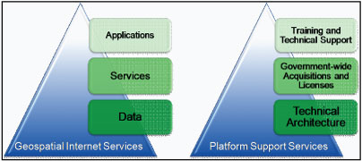
The geoPlatform.gov Offerings.
|
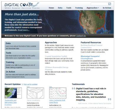
Success Stories Geospatial Platform – The Digital Coast Challenge: Coastal geospatial data exists in literally hundreds of data portals and Web sites throughout Federal, State, and local governments, nonprofit organizations, and academia. For coastal managers, finding the right geospatial data to address coastal issues is half of the challenge. Having the right tools, methods, and case studies to facilitate the application of data to coastal issues is equally as important.
Action: The Digital Coast is a partnership and community resource developed by the National Oceanic and Atmospheric Administration’s Coastal Services Center for use by organizations that manage the Nation’s coastal resources. The Digital Coast was developed to address the needs of its users by providing a simplified way to access geospatial data and the tools and methods to turn that data into information. A Partnership Group, comprised of representatives from the target audience, is used to determine the focus, form, and function of the Digital Coast effort. The Digital Coast Web site was revised and expanded in fiscal year 2010 and now provides access to 24 national level datasets, 35 geospatial tools, 12 training courses, and over 50 case studies (Digital Coast in Action). The accompanying Data Access Viewer was also modified, and now provides simplified access to over 15 terabytes of high-resolution elevation data, orthoimagery, and land cover.
Result: In the past year more than 69,000 users have accessed the Digital Coast site, an increase of almost 300 percent from the previous year. Over the next 10 years the use of the Digital Coast is expected to result in $26.5 million of benefits to more than 450,000 users, exceeding costs by a ratio of 4.5:1.
The Digital Coast Web site provides a comprehensive information gateway for coastal managers.
|
Geospatial Line of Business Creates Efficiencies
In fiscal year 2010, the FGDC announced that all Federal
agencies have access to a single ordering schedule (SmartBUY) for
purchase of their geospatial software needs. The SmartBUY procurement
vehicle promotes effective enterprise-level software management and
leverages the government’s buying power through bulk purchase of
commercial off-the-shelf software products at pre-negotiated prices,
terms, and conditions. This year, the Common Services Work Group (CSWG)
continued to expand the variety of software available. SmartBUY has
been very successful to date. The General Services Administration
estimates that the geospatial software SmartBUY vehicle saved the
government over $8 million in the first three quarters of fiscal year
2010.
The CSWG also completed a Survey of Federal Agency Geospatial
Requirements to identify Federal geospatial priorities in order to
develop acquisition strategies and vehicle(s). Sixty-seven individuals
at twenty-seven agencies in fifteen departments responded to the Survey
of Federal Agency Geospatial Requirements. As a result of the survey,
the CSWG began investigating common metadata editor and geocoding
service options with the goal of developing service-level agreements
that provide additional opportunities for Federal cost savings. The
survey provided a baseline inventory of geospatial requirements for the
Federal Government. The priority data, services, and applications can
be built once and used many times by many agencies and levels of
government. Survey results can be leveraged by the Geospatial Platform
for prioritization of offerings and movement toward portfolio
management of data, services, and applications
The Lifecycle Management Work Group (LMWG), in collaboration with
representatives from sixteen Federal agencies, responded to Office of
Management and Budget (OMB) feedback on the OMB Circular A–16
Supplemental Guidance. OMB requested that the FGDC revise the
Supplemental Guidance to evolve from lifecycle management of individual
datasets to a framework for portfolio management of Federal geospatial
data assets. The updated Supplemental Guidance, delivered to OMB in
July 2010, provides the foundation for portfolio management of
geospatial data assets. The Supplemental Guidance also provides the
outline and direction for similar portfolio management strategies for
services and applications under the Geospatial Platform. Efficient
implementation of the Supplemental Guidance for data and similar
strategies for services and applications across agencies and levels of
government is critical to the success of the Geospatial Platform.
The Geo-Enabled Business Work Group (GEBWG) reached myriad audiences
to communicate the benefits of geospatial approaches and produced many
useful resources during fiscal year 2010. To showcase the value of
geospatial tools in the Federal Government, the GEBWG authored an
article for the Spring 2010 issue of ArcUser magazine entitled
“Geoenabling Federal Business Processes: Improving services to citizens
through place-based approaches” (www.esri.com/news/arcuser/0410/myenvironment.html).
This venue allowed GEBWG to reach a wide national and international
audience. The GEBWG also interviewed numerous Federal geospatial
project managers to create six informational fact sheets in 2010
highlighting the benefits of Federal geospatial tools and lessons
learned through their implementation. These fact sheets are available
on the FGDC Web site, www.fgdc.gov/geospatial-lob/factsheets.
Using the data gathered from these interviews, as well as other
sources, the GEBWG developed a “Common Practices and Lessons Learned”
document that may be used as a resource for Federal geospatial
managers. Additionally, in an effort to guide users in geo-enabling
Federal business processes, the GEBWG created a three part Geo-Enabling
Curriculum. The curriculum explains geospatial tools and approaches,
communicates their value, and lays out a process to begin geo-enabling
a business function or project. Additionally, the GEBWG supported
outreach efforts for the Geospatial Platform, including the development
of a display booth and fact sheet to introduce the Geospatial Platform
at Esri’s signature event, the International User’s Conference, held in
July 2010. The Geospatial Platform will build upon the GEBWG’s
resources and outreach efforts by continuing to encourage the use of
geospatial information to enhance government business processes and by
reaching out to an ever expanding audience.
The Technology and Architecture Work Group (TAWG) focused on
transitioning the Geospatial Profile to a geospatial segment
architecture guidance document supporting efforts of agency architects
and executives to:
- Enhance agency business processes with geospatial capabilities.
- Collect, manage, and utilize geospatial information in efficient and effective ways within an enterprise.
- Leverage geospatial standards and coordination efforts to enable the sharing of geospatial resources across an organization and with partners and the public.
- Produce open, interoperable, discoverable, reusable, and measurable services that limit redundancy while promoting maximum use.
- Implement common design principles that foster a broader Federal geospatial platform of shared and accessible capabilities.
The draft “Geospatial Segment Architecture Guidance” document developed by TAWG incorporates recommendations from OMB and is based on the Federal Segment Architecture Methodology (FSAM) approach. The document is similar to a model document from the Chief Information Officers Council (CIO.gov) on “Identity, Credential, and Access Management.” Final additions to the draft “Geospatial Segment Architecture Guidance” document are underway and include FSAM instructional material interpreted and applied to the objectives of the Geospatial Platform. The TAWG also developed initial requirements to establish a cloud computing pilot project to explore the capabilities, cost, and process to host geospatial data, services, and applications “in the cloud.” By collecting information about the strengths, weakness, cost models, and opportunities related to cloud computing, the work group can provide recommendations for appropriate use of cloud technology to serve and share geospatial resources across the Federal space.
Data.gov Capabilities Increase
As a priority for the President’s Administration, the Open
Government Initiative, Data.gov,
increases the ability of the public to easily find, download, and use
datasets generated and held by the Federal Government. Data.gov
provides descriptions of the Federal datasets (metadata), information
about how to access the datasets, and tools that leverage government
datasets. The data catalogs continue to grow as datasets are added.
Federal, executive branch data are included in the first version of
Data.gov. The purpose of Data.gov is to increase public access to high
value, machine readable datasets generated by the executive branch of
the Federal Government.
A primary goal of Data.gov is to improve access to Federal data and
expand the creative use of those data beyond the walls of government by
encouraging innovative ideas (such as Web applications). Data.gov
strives to make government more transparent and is committed to
creating an unprecedented level of openness. The openness derived from
Data.gov will strengthen our Nation’s democracy and promote efficiency
and effectiveness in government.
The FGDC initially established a team to work with the Data.gov
developers to include geospatial data and capabilities. In 2010, FGDC
Executive Committee members continue to be directly involved with the
development of Data.gov. Federal geospatial data records account for
the vast majority of records currently available through the Data.gov
portal; these records are added to Data.gov from the Geospatial
One-Stop (GOS) registry. Geospatial capabilities of Data.gov continue
to mature and a geospatial data viewing capability was recently
unveiled. The interactive mapping tool, GEO Viewer, is
designed to let users preview the geospatial data available through the
Data.gov catalogs. As Data.gov improves the accessibility of Federal
geospatial data, the Geospatial Platform portfolio management strategy
is being developed. And as GOS’s mission continues to support the data
cataloging of non-Federal sources, FGDC will continue to work on the
close integration of all three efforts to help ensure the efficient and
effective use of resources.
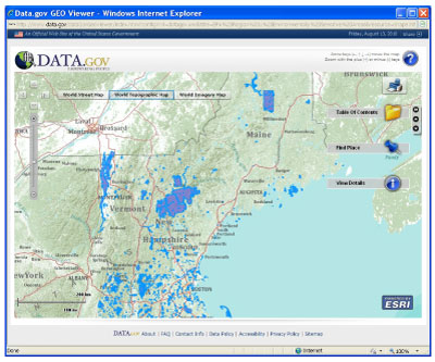
Data.gov GEO Viewer showing EPA Region 1 environmentally
sensitive
areas.
The Geospatial One-Stop
(GOS) portal is the official means for accessing metadata resources
managed in the National Spatial Data Infrastructure (NSDI)
Clearinghouse Network. Metadata held by Federal, State, local, and
Tribal entities, by academic and nonprofit organizations, and by the
private sector are published through the Clearinghouse Network. The GOS
portal (geodata.gov) grew substantially in fiscal year 2010. With more
than 430,000 individual metadata records contributed by 435 publishers,
the portal saw a 60 percent increase in records from fiscal year 2009.
The number of portal users averaged about 100,000 per month in fiscal
year 2010, up from 74,000 in fiscal year 2009.
An impetus leading to the significant increase in the number of
records and usage of GOS was the integration of GOS with Data.gov. A
search of the Geodata catalog (www.data.gov/catalog/geodata)
in Data.gov is actually a search of selected Federal agency records
from the GOS catalog. GOS connectivity to Data.gov is achieved through
the use of a Cataloging Service for the Web (CS-W) interface.
The GOS team continued to work with Federal agencies to promote
collections of records through GOS for discovery in Data.gov. Adding to
collections from the U.S. Census Bureau, the U.S. Environmental
Protection Agency, and other agencies, several large collections of
data were added to GOS this year. The new contributing collections are:
US Topo (the next generation of digital topographic maps from the U.S.
Geological Survey), high resolution aerial orthoimagery from the U.S.
Geological Survey, and Shuttle Radar Topography Mission (SRTM) data
from the National Geospatial-Intelligence Agency and the National
Aeronautics and Space Administration. In all, over 270,000 records are
shared from GOS with Data.gov, which means that 90 percent of the
records available in Data.gov are geospatial data from GOS. This is a
good example how shared and integrated capabilities can increase
governmental transparency and efficiency.
The use of external applications to access the GOS data catalog
through Web services was the focus of four NDSI Cooperative Agreements
Program (CAP) awards this year. Visit www.fgdc.gov/grants/2009CAP/2009CAPDescriptions
for more project details.
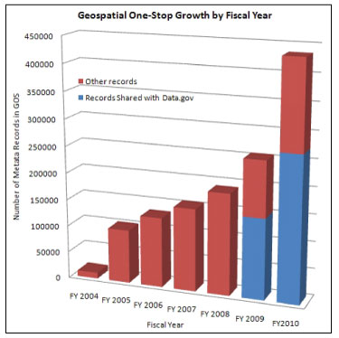
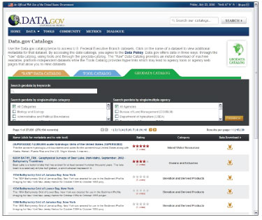
Selected geospatial data from GOS are now searchable in
the
Data.gov Web portal.
| The Geospatial Forum The FGDC sponsored a
Virtual Forum on December 9, 2009. The Forum brought together Federal
Government geospatial executives to discuss the development of a
national place-based policy that addresses economic competitiveness,
environmental sustainability, community health access, and safety and
security. The White House issued a memorandum to department and agency
heads dated August 11, 2009, entitled “Developing Effective Place-Based
Policies for the FY 2011 Budget” that emphasized the need to leverage
place-based policies for better policy planning for a variety of
issues. |
Two-Way Communication with NGAC Produces Results
The National Geospatial Advisory Committee (NGAC) is a
Federal advisory committee sponsored by the Department of the Interior
to provide external advice and recommendations to the member agencies
of the FGDC. The NGAC includes a balanced membership of 28 committee
members representing organizations involved in geospatial issues,
including all levels of government, the private sector, nonprofit
organizations, and academia. The NGAC meets on a quarterly basis and
has established subcommittees that conduct research and develop draft
products between committee meetings.
The NGAC promotes two-way communication on issues of common interest
to the national geospatial community and provides a forum to convey
views representative of our partners and stakeholders. The NGAC serves
as a valuable source of advice and feedback for the FGDC. Over the past
year, the NGAC analyzed and provided recommendations on a number of key
geospatial policy issues. Highlights of the NGAC’s 2010 activities
include the following.
- The NGAC provided initial feedback and advice on the new Geospatial Platform Initiative and adopted the following resolution: “The NGAC endorses the Geospatial Platform concept as described in the Geospatial Platform Roadmap and encourages the Administration, along with Federal agency leadership, to adopt, support, and implement this initiative in partnership with State, local, regional and Tribal governments.”
- The NGAC adopted an Action Plan for committee activities in 2010/2011, including goals and subcommittees organized under the following areas:
-
- Geospatial Platform
- Place-Based Policies
- The National Map
- Partnerships
- Emerging Technologies
- Governance
- Communications
- Broadband Mapping
- Geospatial Workforce
- The NGAC adopted a paper on lessons learned from the geospatial community’s response to the economic recovery bill.
- The NGAC adopted a paper on the benefits of a national geospatial policy.
- The NGAC endorsed the high-level concepts in the NGAC Governance Subcommittee’s draft paper on NSDI metrics.

National Geospatial Advisory
Committee quarterly meeting.
Cooperative Agreements Program Promotes the NSDI
For over 15 years the FGDC has sponsored the Cooperative
Agreements Program (CAP) with the goal of encouraging and enabling the
geospatial data community to participate in building the National
Spatial Data Infrastructure (NSDI). In addition to the benefit of
funding, the NSDI CAP validates an organization’s geospatial work,
which leads to new opportunities. The CAP has created collaborations
within all sectors of government, helped develop an understanding of
geospatial information in organizations and disciplines new to the
NSDI, provided seed money to enable geospatial organizations to
participate in the national effort to implement the NSDI, promoted the
development of standardized metadata in hundreds of organizations,
promoted the importance of geospatial data standards, and greatly
expanded implementation of Web mapping services and Web feature
services.
This year, 23 CAP projects were completed. As in past years the
projects continue to demonstrate the program’s diversity. The three
service-oriented architecture projects completed successfully
demonstrated and documented best practices for wetland permitting,
estimating flood-related property losses, and role-based access
control. The Cross-Border SDI Project made significant progress
deploying new online data, services, and applications to support
critical infrastructure identification by using a common spatial data
infrastructure for Canada and the United States. For more information
please see www.thecarbonproject.com/Projects/crossborder.php.
The Minnesota Structures Collaborative established partnerships and
developed the technical capacity needed to support the long-term
collection, publication, and maintenance of databases pertaining to
structures. Delta State University and the North Carolina Center for
Geographic Information and Analysis completed stakeholder training
materials for the U.S. National Grid. These materials are available on
the FGDC Web site, www.fgdc.gov/training/training-materials.
Finally, over 240 people were introduced to metadata concepts though a
variety of workshops and presentations.
In the 2010 program, CAP awards were given to 26 projects that address
the eight categories outlined below.
- The Metadata Trainer and Outreach Assistance category is designed to support organizations with NSDI knowledge and experience to assist others in geospatial metadata implementation. Of special interest this year were projects that targeted managers and nontraditional geospatial communities. CAP awarded assistance to four projects to advance metadata outreach.
- Framework Data Exchange through Automated Geo-Synchronization projects promote and facilitate the exchange of standardized framework data between State and national data stores through a synchronization service using common data models and services. The governance challenges required to enable automated data exchange will also be addressed. Three awards were given in this category.
- The Fifty States Initiative: Strategic and Business Plan Development category is designed to accelerate statewide coordination activities through consistent strategic and business plan development. CAP awarded assistance to five States to begin developing State plans.
- The Fifty States Initiative: Business Plan Development and Implementation category is designed to build on the work that resulted from an initial Fifty States Initiative award. The projects develop and implement statewide business plans that facilitate the alignment of Federal agencies with statewide geospatial planning activities that advance the NSDI. Five awards were given in this category.
- Return on Investment Methodology and Business Case Development for Multi-agency NSDI projects enables the development of the financial business cases for collaborative spatial data infrastructure projects to gain a better understanding of the cost and more importantly the benefits of spatial data infrastructure projects. This category received three awards.
- The project awarded in the FGDC-Endorsed Standards Development and Implementation Assistance and Outreach category will carry out key recommendations included in the Implementation Plan for the FGDC Wetland Mapping Standard that was adopted in July 2009.
- The category Demonstration of Geospatial Data Partnerships across Local, State, Tribal, and Federal Government supports the NSDI vision of integrating data from all levels of government, to include processes for feeding local data into State holdings, which in turn feed into Federal programs, such as The National Map. The four awards in this category will support the further development and documentation of partnerships and processes to implement this nested approach for one or more data themes of the NSDI.
- One award was given to help build an interoperable environment for emergency response that would become available to all jurisdictions in the State of California.
.
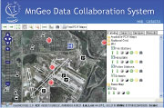
Graphic showing the MnGeoData Collaboration System Web
site
(https://www.sharedgeo.org/MNGEO-ro/public/geomoose.html).
| What are the States saying about the Fifty States
Initiative? Arkansas:
“[Its 2009 Fifty States project] provided a mechanism for
communications with State leadership and stakeholders…” |
Fifty States Initiative Builds Coordination
This year marked the fifth anniversary of the Fifty States
Initiative. The Initiative strengthens statewide coordination by
advancing strategic and business plans. Since 2006, 45 States plus the
District of Columbia and the Virgin Islands have received support
through the NSDI CAP program. In 2010, a new CAP category was initiated
to support further business planning and plan implementation. Ten
awards were given in the Fifty States CAP categories that are listed
above.
A key activity of the Fifty States Initiative is the kickoff meeting
held in conjunction with the National States Geographic Information
Council mid-year conference. The kickoff meeting provides training on
the use of strategic and business planning templates.
When the Fifty States Initiative started, there was a strong sense
that the initiative needed to measure its progress. Last year, a status
report “Measuring Progress of the Fifty States Initiative” was
released. In it, four analyses were reported: (1) analyses of the nine
criteria for successful geospatial coordination from the National
States Geographic Information Council (NSGIC) Survey, (2) analyses of
five questions from the NSGIC Survey as indicators of the level of
success in coordination, (3) survey responses from Federal employees
concerning the effectiveness of the Fifty States Initiative, and (4) a
qualitative assessment based on five case studies of States that have
received awards. This report concluded that there are strong
indications that the Fifty States Initiative meaningfully improved
State geospatial coordination.
In 2010, a survey of all the Fifty States awardees was undertaken to
again gauge progress of the initiative. The State Geographic
Information System (GIS) Coordinators and (or) Fifty States award
recipients were asked to indicate their level of agreement with several
statements describing the awards. In another series of statements,
respondents were asked to identify tangible results that could be
attributed to the State strategic planning process. As the graphic
indicates, the results strongly reflect the positive results of the
initiative even though these results take time to be realized. Those
States receiving awards some years ago are more likely to see positive
results.
To support the FGDC’s effort to advance the Geospatial Platform, the
Fifty States Initiative prepared a report evaluating how State
activities align with the data, services, and applications model of the
Geospatial Platform. In general, concepts regarding a geospatial
platform are new to the geospatial community, but there is potential
for beneficial alignment with State activities.
As the Fifty States Initiative continues into its sixth year, more
emphasis will be placed on business planning and implementation.
Additional efforts are planned to reach out and bring regional and
local governments into the span of the initiative. Work on a Geospatial
Maturity Assessment model also is being advanced to better measure the
progress of geospatial coordination and the Fifty States
Initiative.
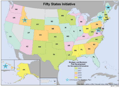
Map showing status of the Fifty States Initiative at the end
of fiscal
year 2010.
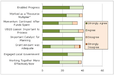
Graphic showing the measure of agreement with statements
about the
Fifty States Initiative.
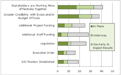
Graphic showing tangible results attributed to the Fifty States Initiative.
International Efforts Continue
The FGDC continued collaborative efforts with GeoConnections
in Canada, sending U.S. Tribal representatives to the Information &
Communications Technology (ICT) Summit in Vancouver, British Columbia.
The event was sponsored by the First Nations Technical Committee for
British Columbia and GeoConnections. One of the U.S. representatives,
Robert Holden, Deputy Director of the National Congress of American
Indians, provided opening remarks at the Natural Resources Day. The
Summit included a presentation on cross-border issues related to the
Columbia River Treaty and other issues that need a spatial data
infrastructure. This was the first time U.S. Tribal representatives
participated in the event.

Robert Holden, Deputy Director
of the National Congress of
American Indians, making
opening remarks at the ICT
Summit.
The FGDC through the Global Spatial Data Infrastructure (GSDI) Association maintains collaborative efforts to advance the international SDIs. The FGDC coordinates and supports the GSDI Small Grants Program that reaches developing countries around the world. In 2010, thirteen projects were supported. The GISCorps of Urban and Regional Information Systems Association (URISA), partners in the GSDI Small Grants Program, provided time and services. Through the GSDI Association, FGDC supports the publication of regional Spatial Data Infrastructure newsletters. In addition, the FGDC hosts a visiting scientist from Korea who supports the Asia Pacific regional newsletter and other GSDI activities. Lastly, FGDC actively planned the GSDI world conference in the Garden City of Singapore in October 2010. The theme for the 12th GSDI conference was “Realizing Spatially Enabled Societies.”
The FGDC Office of the Secretariat continued support for the intergovernmental Group on Earth Observations (GEO) and its Global Earth Observation System of Systems (GEOSS). In addition to providing a co-chair for the Architecture and Data Committee and a Task Force lead for the key architectural tasks within GEO, the FGDC sponsors the operation of a common search capability across all GEOSS assets, known as the GEOSS Clearinghouse, and the Component and Service Registry. Sponsorship is provided through technical support agreements with George Mason University.
The FGDC supported the development and online availability of a Service Status Checker (SSC), written to provide service availability and limited capabilities testing of services registered with Geospatial One-Stop. Because it was based on testing open standards adopted by most NSDI Web Services, the SSC was offered for integration with other national and sub-national Spatial Data Infrastructures (SDIs) to promote monitoring and resolution of quality-of-service information. In 2010, the GeoSUR consortium of 11 countries in Latin America, the SDI of Catalunya, Spain (IDEC), and the Canadian Geospatial Data Infrastructure all registered geospatial Web services with the SSC for daily monitoring of catalogs, map, and data services. The FGDC Secretariat continues to support remote use and integration of these SSC services in the United States and abroad.
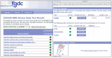
The FGDC Service Status Checker supports the
quality-of-service
testing for the GeoSUR Project in Latin America.
Standards are a key component of the NSDI. Standards are
critical to the development, sharing, and use of geospatial data. The
FGDC develops geospatial data standards for implementing the NSDI, in
consultation and cooperation with State, Tribal, and local governments;
academic institutions; the private sector; and, to the extent feasible,
the international community. The FGDC develops standards only when no
equivalent external standards exist.
In fiscal year 2010, the FGDC released the draft “United States
Thoroughfare, Landmark, and Postal Address Data Standard” for public
review and comment. This standard specifies data content, data
classification, data quality, and data exchange in XML for street
addresses and landmark addresses and points of postal delivery. The
FGDC also released the draft “Coastal and Marine Ecological
Classification Standard” (CMECS) for public review. CMECS provides a
means to classify ecological and habitat units using a common
terminology. It provides a uniform protocol for identifying,
characterizing, and naming ecological units in support of monitoring,
protection, and restoration of unique biotic assemblages, protected
species, critical habitat, and important ecosystem components. The FGDC
is also sponsoring a project to update the standard for Classification
of Wetlands and Deepwater Habitats of the United States, which was
endorsed in 1996.
This year the FGDC began a process to endorse external standards. One
goal of this effort is to endorse and adopt standards to support the
Geospatial Platform. Another goal is to align with standards in the
Department of Defense IT Standards Repository (DISR). Most of the
standards are voluntary consensus standards developed through the
International Organization for Standardization (ISO), the American
National Standards Institute (ANSI), and the Open Geospatial
Consortium; however, a few standards are de facto standards that have
gained acceptance through implementation and use. This is the first
time that the FGDC has sought endorsement of external standards by the
FGDC through the FGDC Policy on Recognition of Non-Federally Authored
Geographic Information Standards and Specifications.
The FGDC conducted an online survey on the FGDC standards process in
2010. Thirty-seven participants completed the online survey. Survey
participants commented on the length of time it takes to develop
standards and identified reasonable lengths of time for steps in the
FGDC standards process. Based on the survey findings and ISO guidance,
the FGDC Standards Working Group proposed time frames for process steps
that can be used as a guide for the developers of standards. The goal
is to bring FGDC endorsement of a standard to three years or less after
approval of a project proposal. The proposed time frame will hopefully
result in standards that meet user needs in a timely manner, while
maintaining the rigor necessary to ensure the legitimacy of a
standard.
Metadata Remains Vital
The FGDC Metadata Working Group (MWG) benefits by
representation from all sectors of the geospatial community: Federal,
State, Tribal, regional, local, academic, nongovernmental, and private.
Quarterly teleconferences keep the working group informed of
developments in the metadata community. The MWG welcomes the Champaign
County (Illinois) Regional Planning Commission, Marshall University
(West Virginia), the National Association of Regional Councils, and
Westat Inc. as the 2010 NSDI Cooperative Agreements Program awardees
and new members of the MWG. The awardees are using classroom and
Web-based training to train their interest groups on the intricacies of
metadata, streamlining its creation, and making metadata the first step
toward data integration. The training is available to Federal, State,
Tribal, regional, and local governments, academia, and nonprofit
organizations. Visit www.fgdc.gov/grants for more
project details.
In 2010, the InterNational Committee for Information Technology
Standards (INCITS) registered a project to develop a “North American
Profile of ISO 19110:2005, Geographic information – Methodology” for
feature cataloging. United States and Canadian experts from INCITS
Technical Committee L1 and its Canadian counterpart, the Canadian
General Standards Board Committee on Geomatics, have developed content
to tailor ISO 19110:2005 to meet the requirements of both countries.
The North American Profile (NAP) of ISO 19110:2005 will enable users of
the FGDC Content Standard for Digital Geospatial Metadata to migrate
entity/attribute information into an ISO-compliant format.
The FGDC Metadata program has also posted to www.fgdc.gov a guidance document
for the geospatial community, “Preparing for International
Metadata.”
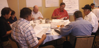
A metadata training session in Billings, Montana.
NSDI Training
Fundamental to the NSDI is collaborative agency training and
self-directed learning that explain various concepts of the NSDI. As
mentioned above, the metadata program benefits from the Cooperative
Agreements Program by utilizing the skills of stakeholders to train
disparate audiences in metadata.
The FGDC benefits from a Tribal training agreement with the Department
of Homeland Security’s Federal Emergency Management Agency. The course
“Emergency Management Framework for Tribal Governments” helps Tribal
communities understand emergency management principles and develop and
implement comprehensive emergency management systems. This 4-day course
provides Tribal leaders and emergency management/response personnel
with a basic understanding of emergency management principles and their
role in leading and directing their tribes in developing and
implementing comprehensive emergency management systems.
The NSDI Training Program is currently a curriculum of 20
self-directed lessons that acquaint the trainee with the breadth of
NSDI topics including Geospatial Data Discovery, Geospatial
Integration, and Geospatial Partnerships, Policy, and Planning. The
NSDI Training Program’s lessons are reviewed and updated annually, and
new lessons are added as they become available. Lessons for three
Framework Data Themes (Geodetic Control, Elevation, and
Transportation-Rail) were added this year and the “Value of Metadata”
lesson has been converted to an e-Learning format as a means to provide
the user an improved learning experience.
The FGDC encouraged the development of NSDI-related training materials
by stakeholders. Content development guidelines have been published
that outline best practices for the development of effective training
materials (
www.fgdc.gov/training/nsdi-training-program/materials/NSDITraining_StakeholderContentDevGuidlines.pdf),
and training materials review and comments are provided by FGDC staff
and contractors. In 2010, NSDI stakeholders, through a NSDI CAP
Category 6 award, developed U.S. National Grid (USNG) lessons (
www.fgdc.gov/training/training-materials#stakeholderstraining).
Imagery for the Nation Advances
Imagery for the Nation (IFTN) is envisioned as a Federal
program conducted in partnership with State and local governments to
address the Nation’s basic business needs for imagery at 1-meter
resolution and higher. The IFTN Phase 1 Project was initiated late in
fiscal year 2008 to explore development of a comprehensive national
imagery program. In August 2009 the Executive Committee approved a
Record of Decision to finalize the program configuration, establish its
governance, and document the basic agreements to complete the IFTN
plan.
Building on this foundation, the Executive Committee and the Work
Groups have begun development in fiscal year 2010 of a business case
and funding request for IFTN. Led jointly by the U.S. Department of
Agriculture (USDA) and the U.S. Department of the Interior (DOI), this
process documents justification for capital investment and plans for
executing IFTN for review by the Office of Management and Budget (OMB).
This is a first step for obtaining OMB approval for a budget request
related to the information technology aspects of IFTN.
A single, joint IFTN business case will represent both DOI and USDA
business requirements and present analysis of several alternatives for
implementing a national imagery solution that meets the needs of IFTN
stakeholders. The IFTN Phase 1 project report, expected to be released
by early 2011 on the FGDC Web site, outlines potential innovations
being considered in this process. To support the process, the Executive
Committee issued a Request for Information (RFI) to industry to gain
additional information on the potential costs and benefits of different
approaches to meet the goals of IFTN. The National
Geospatial-Intelligence Agency led development of the RFI on behalf of
the FGDC. The results of the RFI will be incorporated into later
versions of the IFTN Joint Business Case.
Parcel Data and Public Land Data Move Forward
The FGDC Subcommittee for Cadastral Data continued to
provide updates to the existing national inventory of cadastral data.
Several State cadastral coordinators have been identified and have
assumed the inventory update responsibilities. Following through on one
of the recommendations from the 2009 Mortgage Stakeholders Meeting, the
addition of the parcel number to the Home Mortgage Disclosure Act
(HMDA) was enacted. Three workgroups were established to address
various parcel-related issues. The workgroups are the National Parcel
Workgroup, the Federal Parcel Workgroup, and the Public Land Survey
System (PLSS) and Common Control Workgroup. Membership and goals have
been established for the workgroups.
The National Parcel Workgroup reported that updated sets of parcel
data were provided to the wildland fire community and efforts to
establish sustainable standardized parcel datasets at the State level
built on last year’s efforts. In addition to New Mexico and Washington,
California and Nevada have made significant advances toward sustainable
systems. Washington State developed a tutorial on the use of parcel
data with wildland fire (
www.ruraltech.org/projects/wrl/fldb/fgdc_fire_database.asp)
and California has established a parcel working group that is actively
engaged in data collection and updates. All of the available parcel
data in Nevada and California have been crosswalked and
standardized.
The Federal Parcel Workgroup was organized and met several times via
conference calls. The workgroup includes Federal agencies that create
and maintain a record of federally managed rights and interests.
Interviews with Federal agencies to establish Federal parcel needs,
collection status, and future plans are complete. The interviews
coupled with the workgroup meetings form the basis for defining a
Federal parcel data core dataset. The Federal parcel core data is
expected to complement and work with the core data standard for a
national parcel data system.
The PLSS and Common Control Workgroup worked with the Bureau of Land
Management to establish standardized Public Land Survey System datasets
in 12 western States. This data is compliant with the FGDC Cadastral
Data Content Standard and publication guidelines. In addition, the data
is proposed as the initial standard set of data that is used across
government agencies and private industry and collaboratively maintained
by multiple data stewards. The data is being provided to the States as
requested.
The Cadastral Subcommittee completed an essential metadata profile
including the tools to produce HTML and XML documents of essential
metadata. This tool is Web based and can be found at www.vertex3.com.
|
Success Stories Integration of the National Hydrography Dataset and
the Watershed Boundary Dataset Challenge: Linking the two principal geospatial surface-water datasets of the United States, the National Hydrography Dataset (NHD) and the Watershed Boundary Dataset (WBD) makes it possible to work with these two datasets in the same geospatial file. The linkage also advances the WBD into a more capable geospatial model to give it additional analytical power, similar to the NHD. This combined file then provides interoperability between the two datasets, creating a true integration of the data through data structure links and encouraging more accurate spatial alignment.
Action: In the spirit of Office of Management and Budget Circular A–16, the U.S. Geological Survey, the Natural Resources Conservation Service, and the U.S. Environmental Protection Agency joined forces to lead a consortium of Federal and State agencies to update the WBD for the Nation and advocate for the integration and joint management of the WBD and the NHD. By loading the combined NHD and WBD into a joint database, permanent links between the two datasets are established. This allows any location in the country to easily be reference to a specific drainage unit, the network of streams and lakes that make up the unit, all units upstream and downstream, and all the scientific data linked to the affected drainage network.
Result: By integrating these national datasets (the seamless uniform watershed boundaries of the WBD and the networked surface-water component of The National Map), the NHD allows users to obtain both datasets in a single transaction. As the links between the two datasets are reinforced over time, the cross-referencing of information is improving the integrity of both datasets. As the number of links increases, more analytical power is created for analyzing watershed characteristics and hydrologic flow in a place-based system.
|
FGDC Goals for Fiscal Year 2011
1. Implement OMB Circular A–16 Supplemental Guidance
The Office of Management and Budget (OMB) Circular A–16 Supplemental Guidance provides additional detail and definition to Federal agencies on fulfilling their roles and responsibilities originally established in OMB Circular A–16. In 2011, the FGDC agencies will begin implementing the strategies and practices defined in the Supplemental Guidance that put into place a portfolio management capability for geospatial data and resources. This will include finalizing the list of nationally significant geospatial data themes and data sets, implementing the tested geospatial lifecycle management practices, developing reporting metrics, and providing report templates, training materials, and other support to implementing agencies.
2. Advance the Geospatial Platform
In fiscal year 2011, the development of the Geospatial Platform will continue to progress with the enhancement of the “Modernization Roadmap for the Geospatial Platform” document. New joint business applications, such as the initial Gulf Response application, will be identified for hosting through the GeoPlatform.gov Web site. Increased outreach and inclusion of State, Tribal, and local governments in the governance and requirements development of the Geospatial Platform capabilities will be initiated. An active and inclusive governance model supporting the implementation of business requirement-based common services, data, and applications, hosted on a shared infrastructure, will continue to develop into operational capabilities to support the needs of government and the Nation.
3. Proceed with the Geospatial Line of Business
The Geospatial Line of Business (Geospatial LoB) has
identified activities to focus on in fiscal year 2011, and the
Geospatial Platform offers an opportunity to move toward full
implementation of the policies, guidance, and access to geospatial data
established by the Geospatial LoB. The activities to focus on
include:
- Optimizing sharing of secured data via a shared infrastructure.
- Deploying Cloud Computing capabilities.
- Implementing Portfolio Management as identified in the approved revised OMB Circular A–16 Supplemental Guidance.
- Establishing a multiagency enterprise license agreement for a suite of common geospatial application requirements.
4. Expand Data.gov
Data.gov geospatial capabilities are projected to expand. The initial preview capability, GEO Viewer, will continue to develop and it is also anticipated that Web Map Service (WMS) listings will also be included. A challenge to be addressed is the gap between Data.gov’s Federal data mission and Geospatial One-Stop’s broader NSDI mission that includes non-Federal data. Addressing this gap becomes a key point as the development of the Geospatial Platform, outlined in the President’s 2011 budget, is directed to increase governance and inclusion of requirements from State, Tribal, and local governments. Data documentation, cataloging, and discovery continue to be one of their important geospatial requirements. As the migration of capabilities from Geospatial One-Stop to Data.gov continues, and the Geospatial Platform develops, the role of each will need to be further defined to ensure that both meet their mission requirements and provide complimentary service capabilities.
5. Migrate Geospatial One-Stop
In 2011, Geospatial One-Stop will continue to implement its transition plan, focusing on migration of geospatial search and visualization capabilities into Data.gov. Additionally, a plan will be developed to enable the continued support for geospatial data index, search, and retrieval of the other Geospatial One-Stop registered datasets from the geospatial network of State, Tribal, local, and other Federal partners and constituents.
6. Collaborate with the National Geospatial Advisory Committee
The National Geospatial Advisory Committee (NGAC) will hold
three to four public meetings in fiscal year 2011. The FGDC will manage
the review, disposition, and implementation of NGAC recommendations.
Goals for the NGAC in fiscal year 2011 include the following:
- Provide ongoing review, feedback, and recommendations regarding the development and implementation of key Administration initiatives, including the Geospatial Platform and the Place-Based Policies initiatives. These areas will be a primary focus of the NGAC’s work in fiscal year 2011.
- Through its subcommittees, the NGAC will also provide advice and recommendations to the FGDC in the subject areas of emerging technology, governance, partnerships, broadband mapping, geospatial workforce, and The National Map.
- The FGDC will review and respond to advice and recommendations from the NGAC.
- The FGDC will complete the next cycle of NGAC nominations and appointments in fiscal year 2011.
7. Align the Fifty States Initiative
In fiscal year 2011, ten awards are planned for the Fifty States Initiative, with a kickoff meeting in February or March 2011. In addition, efforts to align the FGDC return-on-investment efforts with the Fifty States Initiative will proceed. Efforts to include regional and local governments in the initiative are expected—to align regional and local efforts with the initiative’s strategic plans. Lastly, the initiative will continue to support the Geospatial Platform.
8. Advance International Activities
The FGDC Office of the Secretariat will continue to support the Group on Earth Observations (GEO) and its Global Earth Observation System of Systems (GEOSS) through operational support for the federated search facility (GEOSS Clearinghouse) and the Component and Service Registry. FGDC staff members will also continue to support tasks within and co-chairmanship of the GEO Architecture and Data Committee.
9. Advance Standards Activities
The FGDC is coordinating with the National
Geospatial-Intelligence Agency to align the standards activities. Goals
include alignment of the FGDC standards process and the Geospatial
Intelligence Standards Working Group (GWG) standards process with
respect to the timing and review of documents and the FGDC endorsement
of standards in the Department of Defense IT Standards Repository
(DISR), where appropriate.
The following standards are expected to be endorsed by the FGDC in
fiscal year 2011:
- United States Thoroughfare, Landmark, and Postal Address Data Standard
- Update of the Classification of Wetlands and Deepwater Habitats of the United States
10. Advance the Implementation of Imagery for the Nation
It is expected that by early 2011 a report on the FGDC Phase 1 Project will be released. The 2011 goals for the IFTN include advancing the IFTN Joint Business Case and funding request for fiscal year 2012, refining the vision and plans for IFTN governance, and continuing to develop community support for IFTN.


