Office of Management and Budget (OMB) Circular A–16 provides direction for Federal agencies that produce, maintain, or use spatial data in the National Spatial Data Infrastructure (NSDI). The circular identifies 34 data themes of national significance and denotes which are framework data themes. This appendix includes descriptions of the following framework data and data themes: cadastral, elevation, geodetic control, hydrography, orthoimagery, cultural and demographic statistics, soils, watershed boundaries, and wetlands.
Framework Data Theme: Cadastral
Responsible agency: U.S. Department of the Interior, Bureau of Land Management (BLM)
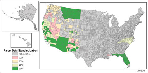
Description: The BLM is the lead Federal agency for cadastral data and chairs the FGDC Cadastral Subcommittee. Cadastral data describe the geographic extent of rights and interests in real property. Cadastral data include cadastral reference data (see following page) and land parcel data. Under BLM’s leadership, the Cadastral Subcommittee develops and implements plans to coordinate cadastral data-related activities among Federal, State, Tribal, and local governments and the private sector and reports on its activities to the FGDC. In the western United States, the FGDC Cadastral Subcommittee continues to work with the wildland fire community to identify sources of land parcel data, standardize available data, and build sustainable operational procedures to provide land parcel data in coordination with States. In other regions of the country, such as the Midwest and the Southeast, the Subcommittee continues to work with State coordinators to identify county cadastral data contacts. The graphic below represents progress as of July 2011. Through September 2011, all of California data and available data in Utah and Wyoming have been standardized.
Parcel Data Standardization Status by County
(Click on image for larger version.)
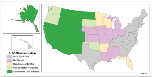
The Public Land Survey System (PLSS) is a cadastral
reference system used to divide public domain lands, which are lands
managed by the Federal Government. The original public domain included
the land ceded to the Federal Government by the thirteen original
States, supplemented with acquisitions from native Indians and foreign
powers. It encompasses major portions of the land area of 30 States.
Standardized PLSS representation supports geographic information system
(GIS) applications that facilitate data integration and enables
searches by PLSS location. The statewide standardization PLSS
representation is based on legal cadastral survey records. The graphic
below indicates progress through July 2011.
The Cadastral Subcommittee has developed guidance for States to use
when developing, publishing, and maintaining all standardized cadastral
information (cadastral reference and land parcel data) for
government-to-government data sharing. State stewardship of cadastral
data has seven levels, or phases, that lead to a State aggregating and
publishing authoritative local data and serving as a trusted source.
The levels range from level 1, in which a State coordinator identifies
and assembles a current inventory of the State’s sources of cadastral
data, to level 7, in which statewide data are assembled into a single
dataset that can be combined seamlessly with other State and Federal
cadastral data.
PLSS Standardization Status by State
(Click on image for larger version.)
Framework Data Theme: Elevation
Responsible agency: U.S. Department of the Interior,
U.S. Geological Survey (USGS)
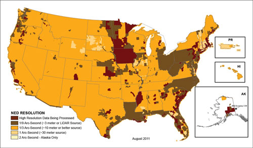
Description: The National Elevation Dataset (NED) contains elevation data that provide three-dimensional surface models of the Earth’s surface. The USGS makes elevation data available for land areas and, in cooperation with the National Oceanic and Atmospheric Administration, under coastal waters. The USGS identifies digital elevation data based upon the resolution (spacing between the points) of a grid. One arc-second resolution (equivalent to 30-meter resolution) elevation data are complete and available for the entire United States, except Alaska. Current USGS efforts are concentrated on providing finer resolution of elevation data at 1/3 and 1/9 arc-second (equivalent to 10- and 3-meter resolutions, respectively) grid spacing. The data are developed from the best available data from Federal, State, and local agencies and private sector partners.
National Elevation Dataset Source Resolution
(Click on image for larger version.)
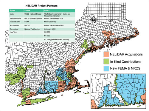
Northeast LiDAR Partners Project
(Click on image for larger version.)
In fiscal year 2011, all high-resolution elevation projects funded through the American Recovery and Reinvestment Act (ARRA) in 2009–10 are to be completed and the data made available for dissemination as Digital Elevation Models from the NED and also, as in the case of LiDAR source data, Log ASCII Standard (LAS) files from the Center for LiDAR Information Coordination and Knowledge (CLICK). Many of these ARRA-funded projects are large, multiple-partner cooperative arrangements requiring precision coordination. One such project is the LiDAR for the Northeast project covering the coastline of New England, New York to the Canada–United States border in Maine. Six States, five Federal agencies, and eight State agencies and nongovernmental organizations are partners in this project, which will result in approximately 13,500 square miles of new and in-kind LiDAR data in the public domain.
Framework Data Theme: Geodetic Control
Responsible agency: National Oceanic and Atmospheric Administration (NOAA), National Geodetic Survey
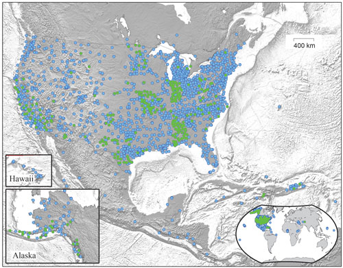
Description: NOAA’s National Geodetic Survey manages a network of continuously operating reference stations (CORS) that provide Global Navigation Satellite System data to define and maintain the National Spatial Reference System. As a multipurpose cooperative endeavor involving more than 200 government, academic, and private organizations, CORS data support three-dimensional positioning, meteorology, space weather, and geophysical applications. Improved coordinates for these geodetic control stations, which are the result of improved analysis of more than 10 years of data, will be made available in fiscal year 2012. The map shows the distribution of 1,826 stations, including 221 recent additions (green dots).
Continuously Operating Reference Stations (CORS) Network, July 2011
(Click on image for larger version.)
Framework Data Theme: Hydrography
Responsible agency: U.S. Department of the Interior, U.S. Geological Survey (USGS)
Description: The National Hydrography Dataset (NHD)
includes a common data model that contains nationwide coverage of
surface water features at 1:100,000 scale and 1:24,000 scale. These
data provide a universal solution for hydrography across the Nation and
have widespread application in pollution control, hydrology, resource
management, and fisheries research. The USGS provides the central
database, technical development, distribution, data integration,
leadership, program management, and coordination.
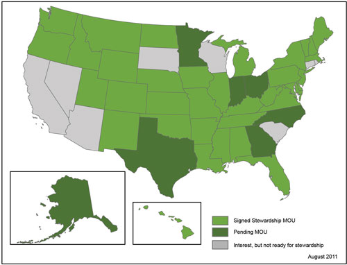
Maintaining these data is largely accomplished through a program of
data stewardship using Memorandums of Understanding (MOUs) where the
user community is empowered to make necessary updates. The USGS
facilitates the stewardship by providing the methods, tools, training,
and guidance to allow users to assume responsibility for maintenance. A
complete modernization of the maintenance toolset is underway to expand
the user base able to participate in data stewardship. The USGS
provides grant funding to States to help them establish stewardship
operations. A number of States are now revising their hydrography data
to 1:4,800- and 1:2,400-scale resolutions.
Status of National Hydrography Dataset Stewardship Program
(Click on image for larger version.)
Framework Data Theme: Orthoimagery
Responsible agency: U.S. Department of the Interior,
U.S. Geological Survey (USGS)
Description: The USGS is the designated lead Federal agency for the NSDI orthoimagery data theme and executes its OMB Circular A–16 responsibilities as the theme lead through the National Digital Orthophoto Programs (NDOP). NDOP was chartered in 1993 as a consortium with the purpose of developing and maintaining national orthoimagery coverage in the public domain by establishing partnerships with Federal, State, Tribal, local, and private organizations. The consortium members include the Bureau of Land Management, the Farm Service Agency, the Federal Emergency Management Agency, the National Geospatial-Intelligence Agency (NGA), the National Oceanic and Atmospheric Administration, the National Resources Conservation Service, the National States Geographic Information Council, the U.S. Census Bureau, the U.S. Forest Service, and the U.S. Geological Survey. The primary Federal programs for NDOP are the Farm Service Agency’s National Agriculture Imagery Program (NAIP), the NGA Homeland Security Infrastructure Program (HSIP) 133 Cities Urban Area Initiative, and the USGS National Orthoimagery Program.
USGS National Orthoimagery Program
The USGS National Orthoimagery Program concentrates on
acquiring imagery through partnerships with Federal, State, Tribal,
regional, and local agencies. The USGS, along with other Federal and
State agencies, contributes funds annually to support the USDA-FSA’s
National Agriculture Imagery Program (NAIP) current maintenance cycle.
In addition to direct funding support, the USGS (through the Geospatial
Liaisons) coordinates partnerships with State and local agencies to
further leverage the NGA’s 133 Cities Urban Area Initiative funding
pool and expand the project to support local needs. The USGS also
provides quality assurance support for the 133 Cities Urban Area
Initiative. The USGS makes all public domain digital orthoimagery
acquired through its partnership agreements available to the general
public through The National Map Seamless Server and provides
for data archiving. Currently, 1-meter orthoimagery from the NAIP and
higher resolution orthoimagery in support of the 133 Cities Urban Area
Initiative are available on the Seamless Server. Data availability
graphics can be found at seamless.usgs.gov/data_availability.php?serviceid=Dataset_5
and seamless.usgs.gov/data_availability.php?serviceid=Dataset_7.
The USGS National Orthoimagery Program supports the National Geospatial
Program by making the imagery available in US Topo maps and through
USGS Web services. The USGS National Orthoimagery Program also supports
the USGS science programs.
USDA-FSA National Agriculture Imagery Program
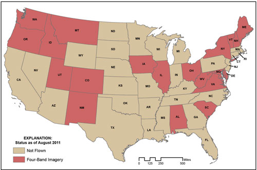
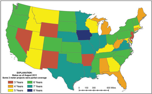
The National Agriculture Imagery Program (NAIP) annually acquires imagery during the growing season and is the largest single civilian mapping program in U.S. history. The Farm Service Agency (FSA) and other U.S. Department of Agriculture (USDA) agencies use the imagery to administer farm programs and agriculture-related disaster recovery programs. The imagery is in the public domain and is widely used by Federal, State, and local agencies, as well as by private entities and businesses. A few examples of the business processes that the data have been used to support are economic development, emergency response, environmental management, growth planning, health and human services, homeland security, precision farming and other agribusiness activities, and transportation planning. FSA’s priority is to collect data on privately owned farmland as identified by common land unit boundaries, and the agency has established effective cost-share participation with other Federal and State partners for collection outside of those areas. The funding level for NAIP in 2011 supported acquisition of 1-meter imagery for 20 States. Since the program began as a pilot in 2002, it has provided nearly three full cycles of complete 1-meter coverage of the continental United States, giving all States in the lower 48 an imagery currency age of 3 years or less.
2011 NAIP Data Acquisitions
(Click on image for larger version.)
Total Years of NAIP Imagery, 2003–2011 (1- or 2-meter coverage)
(Click on image for larger version.)
NGA HSIP 133 Cities Urban Area Initiative
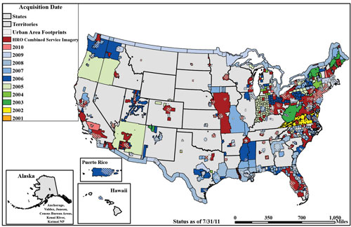
The Homeland Security Infrastructure Program (HSIP) 133 Cities Urban Area Initiative annually acquires imagery during the spring and fall leaf-off seasons; the focus of this initiative is the 133 cities that are defined in the 2002 tiger team report that was produced jointly by the National Geospatial-Intelligence Agency (NGA) and the USGS. NGA collects this imagery through partnership with the USGS and uses it to support the Homeland Defense, Homeland Security, and Emergency Preparedness, Response, and Recovery mission to protect the Nation’s infrastructure in accordance with Homeland Security Presidential Directive/HSPD–7 and the National Strategy for the Physical Protection of Critical Infrastructure and Key Resources. The collected imagery data also support mutually beneficial partnerships to both enhance and share data among Federal Government agencies and with State and local jurisdictions. This initiative supports partnership and coordination efforts with other Federal agencies such as the Department of Homeland Security, the USGS, and the U.S. Army Corps of Engineers. The collected imagery is largely in the public domain and is widely used by Federal, State, and local agencies, as well as by commercial, private, and nonprofit entities. The USGS provides this imagery to the civilian community through The National Map Seamless Server located at the EROS Data Center, and the NGA coordinates imagery distribution to its mission partners. The goal for this initiative is to refresh imagery for the 133 cities on a 2- to 3-year cycle, which has been largely accomplished since the initiative’s inception in 2002; imagery for nearly all the cities has been collected twice and collections for many cities are on their fourth or fifth iteration. In fiscal year 2011, the initiative funded 32 projects in 22 States, as well as in the Territory of Guam.
HSIP 133 Cities Urban Area Imagery Initiative: Fiscsal Year 2011 Imagery Acquisitions
(Click on image for larger version.)
Data Theme: Cultural and Demographic Statistics
Responsible agency:U.S. Census Bureau
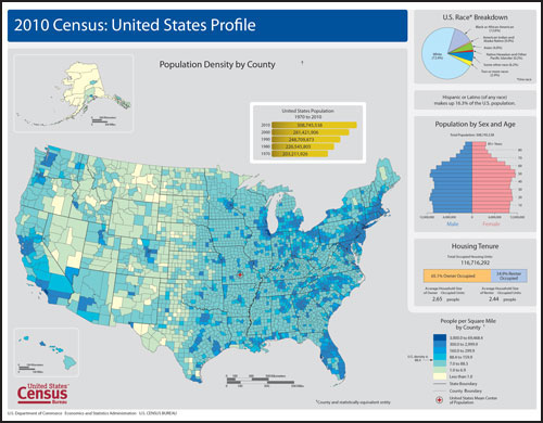
Description: This U.S. Census Bureau-managed theme contains characteristics of people, the nature of the structures in which they live and work, the economic and other activities they pursue, the facilities they use to support their health and recreational and other needs, the environmental consequences of their presence, and the boundaries as well as names and numeric codes of geographic entities used to report the information collected. The U.S. Census Bureau’s 2010 Census Profile maps offer a graphic overview of selected demographic information from the 2010 Census of Population and Housing. In addition to a population density map, each page includes a pie chart showing percent of total population by race, a population pyramid, and a bar chart illustrating housing occupancy rates. The map series consists of one page-sized map for each State in the United States, the District of Columbia, and Puerto Rico, as well as a national map. Initial census counts became available in December 2010. As 2010 census data are tabulated and released, the Census Bureau creates many geospatial products including thematic and reference maps and posts them at: www.census.gov/geo/www/. As 2010 data continue to be released, the Census Bureau will continue to provide geospatial products reflecting the status of America—changes in population trends and geographic areas—as determined by the 2010 census.
2010 Profile Map United States
(Click on image for larger version.)
Data Theme: Soils
Responsible agency: U.S Department of Agriculture (USDA), Natural Resources Conservation Service Soil Survey Division
Description: The USDA National Resources Conservation
Service Soil Survey Division provides leadership and services to
produce and deliver science-based soil information (including digital
maps, attribute tables, and other types of publications) to help in the
understanding and management of global resources. This service is
provided through the National Cooperative Soil Survey (NCSS) program.
The NCSS is a nationwide partnership of Federal, State, and local
agencies, and private entities and institutions. This partnership works
collaboratively to investigate, inventory, document, classify,
interpret, disseminate, and publish information about soils of the
United States and its trust territories and Commonwealths. The
activities of the NCSS are carried out on national, regional, and State
levels.
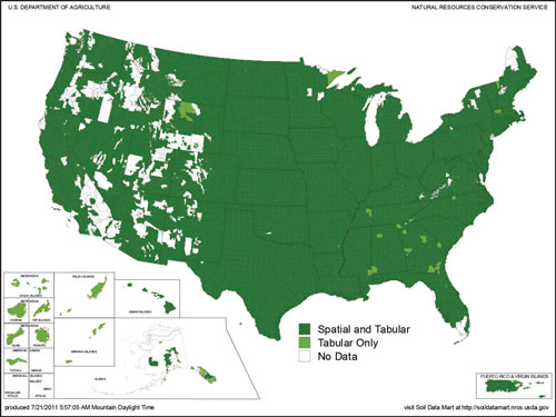
The map below illustrates the current status of the Soil Survey
Geographic database (SSURGO) for the United States. Dark green color
indicates that detailed digital maps and associated attribute tables
are available. Light green color indicates that only attribute tables
are available. White areas indicate that no soil survey has been
completed. During fiscal year 2011, NCSS staff completed 34.8 million
acres of initial and update soil survey mapping. In fiscal year 2010,
38.8 million acres of initial and update soil survey mapping were
completed.
Available Soil Survey Data, July 21, 2011
(Click on image for larger version.)
Data Theme: Watershed Boundaries
Responsible agency: U.S. Department of the Interior, U.S. Geological Survey (USGS), and U.S. Department of Agriculture, Natural Resources Conservation Service (NRCS)
Description: The seamless, national Watershed
Boundary Dataset (WBD) is a hydrologic unit framework of uniform size
for the United States. It is used for programmatic planning,
implementation, and reporting at the national, regional, and local
levels. This includes use in multiple analytical and statistical
applications. The WBD is certified to national certification standards
for the conterminous United States and Hawaii at 1:24,000 scale, the
Caribbean at 1:25,000 scale, and Alaska at 1:63,360 scale. Its
development and strategic direction is guided under the leadership of
the interagency Subcommittee on Spatial Water Data. The USDA-NRCS and
USGS have joint management responsibilities under OMB Circular
A–16.
Current efforts are focused on stewardship and integration of the WBD
with the National Hydrography Dataset (NHD) and other datasets such as
the Geographic Names Information System (GNIS) and harmonization of
hydrologic units with Canada and Mexico. Additional data enhancements;
for example, improved interpretations along coastal areas, and
value-added attribution to facilitate WBD and NHD applications are in
progress. WBD planning allows for (but does not require) the
incorporation of local partner data at high resolution, plus two
additional next down nested tiers at the 14- and 16-digit levels.
This dataset is available through the Geospatial Data Gateway, located
at datagateway.nrcs.usda.gov.
Watershed Boundary Dataset (WBD) Status

(Click on image for larger version.)
Data Theme: Wetlands
Responsible agency: U.S. Department of the Interior, Fish and Wildlife Service (FWS)
Description: The National Wetlands Inventory (NWI) provides management, coordination, and delivery of the Wetlands Layer of the NSDI as required under the Emergency Wetlands Resources Act and as part of OMB Circular A–16. The Wetlands Layer consists of wetlands, deepwater, and riparian geospatial data that are served in a seamless geospatial data repository using a state-of-the-art Wetlands Mapper, served through a Web Mapping Service (WMS), downloaded by State, registered through Geospatial One-Stop and Data.gov, and available on the Google Earth™ mapping service. Wetlands data provide the classification, location, and extent of wetlands and deepwater habitats. To facilitate wetlands data development, the FGDC endorsed the Wetlands Mapping Standard in July 2009. The Wetlands Mapping Standard is designed to support current and future digital mapping requirements. It is intended to be extendable, forward-looking, and able to accommodate technology enhancements over time. Adherence to the Wetlands Mapping Standard is required for all wetlands mapping activities funded or conducted by the Federal Government.
The wetlands data layer is 65 percent complete as shown in the status map: 71 percent of the conterminous United States plus another 8 percent in raster scans; 30 percent of Alaska; 100 percent of Hawaii, Guam, and Saipan; and 65 percent of Puerto Rico and the U.S. Virgin Islands. In fiscal year 2011, NWI created a new online Wetland Mapping Training course with training on the Wetlands Mapping Standard and the Wetlands Classification Standard, initiated a Wetlands Subcommittee Working Group maintenance review of the Classification Standard, participated in the Federal GeoCloud effort, and expects to receive over 55 million data requests. The current availability of wetlands data is shown below.
Status of Online Wetlands Data

(Click on image for larger version.)
Appendix C

