Contents
FGDC Accomplishments for Fiscal Year 2011
The National Broadband Map: Collaboration Works
FGDC Advances the National Spatial Data Infrastructure
FGDC Goals for Fiscal Year 2012
Appendix A. FGDC Leadership Profiles
Appendix B. FGDC Structure and Membership
Appendix C. Status of NSDI Data Themes
Appendix D. Glossary of Abbreviations and Terms
Message from the FGDC Chair
I am pleased to present the Federal Geographic Data
Committee’s (FGDC’s) annual report for 2011, describing the activities
and accomplishments of the FGDC partner agencies over the past year.
2011 has been a year of accomplishment and progress, with significant
advances in the development of collaborative geospatial data and
technology. We look forward to continuing this progress in the coming
year.
Over the past year, the partner agencies of the FGDC have made
significant progress on a number of fronts. For example, the FGDC has
made significant progress in conceptualizing and beginning
implementation of the Geospatial Platform initiative. The Geospatial
Platform, which was described in the President’s fiscal year 2011
budget, will be an accessible, reliable, and cost-effective collection
of data, applications, and services that will provide a foundation to
help address the White House’s priorities for data sharing,
transparency, and collaboration. In 2011, the FGDC developed a
conceptual roadmap for the Platform and received very helpful feedback
from external partners on the National Geospatial Advisory Committee
and through a public outreach process. The FGDC also began the
implementation of the first operational phase of the Platform in 2011.
We are excited by the prospects for this new initiative, and we look
forward to working with our partners in the coming year to realize the
vision for the Platform.
The FGDC has also provided support for key White House initiatives. For
example, the FGDC worked with the Office of Management and Budget (OMB)
to develop new Supplemental Guidance to OMB Circular A–16,
“Coordination of Geographic Information and Related Spatial Data
Activities.” The new guidance outlines a process to use portfolio
management approaches to more effectively manage Federal geospatial
assets and investments. OMB issued the new guidance to agencies in
November 2010.
In addition, the FGDC has made significant progress in the area of
geospatial standards. The FGDC adopted 64 external standards, including
many from the International Organization for Standardization (ISO) and
the Open Geospatial Consortium, and also adopted the U.S. Thoroughfare,
Landmark, and Postal Address Data Standard. In addition, the FGDC is
coordinating standardization activities with the Department of Defense.
Standards are a key component of the National Spatial Data
Infrastructure and we are pleased with the progress in this vital
area.
Fiscal year 2012 will focus on continued collaboration to better enable
public-private partnerships and investments, and continued progress on
development of the Geospatial Platform and other tools and data for the
benefit of the agencies and public we serve. We are also rejuvenating
the FGDC Steering Committee and working with senior officials in our
partner agencies to advance national geospatial programs. We look
forward to a productive year.
I thank all of you who have contributed to the success of the FGDC over
the past year.
Sincerely yours,
Anne Castle
FGDC Chair
Assistant Secretary of the Interior for Water and Science

FGDC Accomplishments for Fiscal Year 2011
1. Geospatial Line of Business
The Geospatial Line of Business obtained the Office of Management and Budget (OMB) endorsement for the OMB Circular A–16 Supplemental Guidance, which includes processes, roles, and responsibilities for managing National Geospatial Data Assets datasets and themes, and a repeatable process for adjusting OMB Circular A–16 Appendix E that describes the National Spatial Data Infrastructure geospatial data themes. For more information click here.
2. Portfolio Management
The Geospatial Line of Business continues to make strides towards portfolio management through the development of an implementation strategy and agency implementation plan templates. Another significant accomplishment is the development of a current inventory of National Geospatial Data Assets. For more information click here.
3. Geospatial Platform
The “Modernization Roadmap for the Geospatial Platform”
document, completed in March 2011, provides a framework to describe how
the concepts and goals of the Geospatial Platform were developed and
released. This “Roadmap” concludes the upfront planning process for the
Geospatial Platform and paves the way for implementation
activities.
The
redesigned Geospatial Platform website (www.GeoPlatform.gov) was released. The
Platform is a managed portfolio of common geospatial data, services,
and applications contributed to and administered by authoritative
sources and hosted on a distributed, cloud-based infrastructure. The
Geospatial Platform is used by government agencies and partners to meet
their mission needs and the broader needs of the Nation. For more
information click
here.
4. Geospatial One-Stop and the Clearinghouse Network
In fiscal year 2011, the Geospatial One-Stop (GOS) project continued to focus on integrating its geospatial data with Data.gov. Connectivity between GOS and Data.gov takes place using GOS Web service capabilities that enable searches for geospatial data through applications beyond the GOS portal. During fiscal year 2011, the GOS data collection grew to over 678,000 records, of which over 391,000 are shared through Data.gov. The GOS to Data.gov integration is in its final stages and many of the capabilities of GOS will be integrated into Data.gov in the coming months (early fiscal year 2012). At that time, the GOS portal, www.geodata.gov, will cease to exist, and visitors to that portal will be redirected to a geospatially enabled page for Data.gov. For more information click here.
5. National Geospatial Advisory Committee
The National Geospatial Advisory Committee (NGAC) was established by the Department of the Interior to provide external advice and recommendations to the FGDC. During the past year, the NGAC has analyzed and provided feedback and recommendations on the Geospatial Platform Initiative, The National Map, geolocation privacy, the National Land Imaging Program, Transportation for the Nation, and the Federal Aviation Administration’s laser pointer issue. The NGAC has also adopted white papers on local government Geographic Information System best practices and best practices for interagency data sharing. For more information click here.
6. Standards
The FGDC endorsed the United States Thoroughfare, Landmark, and Postal Address Data Standard. The standard covers street addresses, which are the location identifiers most commonly used by all levels of government and the public. Addresses are critical for administrative records, emergency and first response, research, marketing, mapping, geospatial information systems, routing and navigation, and law enforcement. For more information click here.
7. Geospatial Metadata
The FGDC led a community effort to generate and compile input to the “ISO 19115: Geographic Information – Metadata” five-year review. The information collected from the community provided critical insight into issues experienced when applying the standard to real world geospatial data and operations. A revised draft international standard is expected to be released in November 2011 as “ISO 19115-1 Geographic Information – Metadata - Fundamentals.” For more information click here.
8. Fifty States Initiative
Nine States completed and began implementing strategic and (or) business plans that facilitate the coordination of geospatial programs, policies, technologies, and resources in their States and with the Federal Government. For more information click here.
9. NSDI Training Program
The FGDC partnered with all sectors of government, academia, Tribal Nations, and the private sector to provide National Spatial Data Infrastructure (NSDI) related training. Cooperative agreements, memorandums of understanding, contracts, and cost sharing were utilized to design and lead workshops, develop training materials for the classroom and the Web, and support travel and logistics. In most cases, Federal agencies, including the National Oceanic and Atmospheric Administration and the U.S. Geological Survey, provided trainers and training materials; State and local governments and U.S. Geological Survey Geospatial Liaisons provided logistical support; and private-sector companies sometimes contributed facilities and supplies. By sharing resources, these organizations were able to collectively address the NSDI training needs of their communities. For more information click here.
|
Success Story Monitoring Trends in Burn Severity Program Challenge: There is a need to provide summary information regarding the effects of large wildfires to agency leaders, elected officials, and the general public. The Wildland Fire Leadership Council (WFLC), which implements and coordinates National Fire Plan (NFP) and Federal Wildland Fire Management Policies, adopted a strategy to monitor the effectiveness and effects of the National Fire Plan and the Healthy Forests Restoration Act (HFRA). One component of this strategy is to assess the environmental impacts of large wildland fires and identify the trends of burn severity on all lands across the United States.
Action: Monitoring Trends in Burn Severity (MTBS), a project initiated in 2005, is conducted through a partnership between the U.S. Department of Agriculture’s Forest Service Remote Sensing Applications Center (RSAC) and the U.S. Geological Survey’s National Earth Resources Observation and Science (EROS) Center. The project’s main objective is to provide a national analysis of trends in burn severity for the National Fire Plan. The geospatial and tabular data generated by MTBS can be used at a range of spatial, temporal, and thematic scales and are intended to meet a variety of information needs that require consistent data about fire effects.
Result: The project generates a suite of geospatial data products for each fire including burned area perimeters, 30 meter pre/post-fire Landsat imagery subsets, burn severity data, and summaries based on Geographic Information System (GIS) analysis with key geospatial data layers. To date, over 13,000 fires have been mapped by the MTBS project. The number of fires that will be mapped during the course of the project is estimated to exceed 15,000. MTBS developed a public-facing website (www.mtbs.gov) with robust data delivery capabilities. Users can pull data bundles at multiple scales, including national, regional, and fire level. In addition to accessing geospatial data bundles, the website also allows users to query the extensive MTBS database. Visualization and analysis tools are provided to assess fire trends at various scales and in the context of key geographic strata. Tabular data for specified queries can also be downloaded for further, customized analysis.
|
The National Broadband Map: Collaboration Works

Introduction
A unique collaboration among Federal agencies, State
governments, and the private sector paved the way for the Nation’s
first geospatial dataset of broadband availability and the first
public, searchable nationwide map of broadband availability. Launched
on February 17, 2011, the National Broadband Map, available at www.broadbandmap.gov, is an unprecedented
searchable database of information on high-speed Internet access. The
Map and its accompanying dataset fill an important policy gap,
providing—for the first time—information at a detailed geographic level
about broadband availability across the country. The products also
represent the culmination of two years of committed partnership by
State agencies and non-profit organizations, public and private sector
broadband providers, and the Federal Government. The effort exemplifies
the goals of the Office of Management and Budget (OMB) Circular A–16,
which established a coordinated approach to developing the National
Spatial Data Infrastructure (NSDI), including the development of
national data and collaborative partnerships.
The National Broadband Map supports efforts to expand broadband access
and adoption in communities at risk of being left behind in the 21st
century economy and to help businesses and consumers seeking
information on their high-speed Internet options. It does this by
providing better data with which consumers, business leaders, and
policymakers can make more informed decisions. The first dataset
resulting from this Federal-State-private sector partnership included
25 million searchable records showing where broadband Internet service
is available, the technology used to provide the service, the maximum
advertised speeds of the service, and the names of the providers
offering the service. In addition, they include the type and speed of
the service to which community anchor institutions—such as libraries,
schools, and hospitals—subscribe. The interactive and searchable
website displaying the data allows users to search by address to find
the broadband providers and services available in the corresponding
census block or road segment, view the data on multiple maps, or use
other interactive tools to compare broadband across various
geographies, such as States, counties, or congressional
districts.
A Call to Action
The National Broadband Map implements the joint purposes of
the American Recovery and Reinvestment Act (Recovery Act) and the
Broadband Data Improvement Act (BDIA), which envisioned a comprehensive
program, led by State entities or non-profit organizations working at
their direction, to facilitate the integration of broadband and
information technology into State and local economies. In calling for
the National Broadband Map, the Recovery Act required the National
Telecommunications and Information Administration (NTIA) to:
Develop and maintain a comprehensive nationwide inventory map of
existing broadband service capability and availability in the United
States that depicts the geographic extent to which broadband service
capability is deployed and available from a commercial provider or
public provider through each State. Not later than 2 years after the
date of the enactment of this Act, the Assistant Secretary shall make
the broadband inventory map developed and maintained pursuant to this
section accessible by the public on a World Wide Web site of the
National Telecommunications and Information Administration in a form
that is interactive and searchable.1
In addition, the Recovery Act provided the funding for the Map and
linked the development of the Map to Public Law 110-385, the State
Broadband Data and Development Grant program, a key component of
BDIA.
With only 24 months to meet its congressional deadline, NTIA and its
partners worked quickly. Less than five months after Congress passed
the Recovery Act, in July 2009, NTIA released program rules through a
Notice of Funds Availability. Making one grant award available per
State, Assistant Secretary Lawrence E. Strickling noted that the data
States gathered would be “used to create the national broadband map,
and in addition, States will be able to create their own broadband maps
tailored to their specific needs.”2 NTIA awarded the grants
beginning in October 2009 and all but a few of the 56 grantees had
funding in-hand by the end of January 2010, just 13 months prior to the
statutory deadline for publication of the National Broadband Map.
1Section 6001(1) of the American Recovery and
Reinvestment Act of 2009, Public Law No. 111-5 (2009), codified at 47
U.S.C. 1305(1).
2Available at: www.ntia.doc.gov/press-release/2009/ntia-unveils-program-help-states-map-internet-infrastructure.
Accessed: September 5, 2011.
Critical Partnerships
Collaboration between grantees and broadband providers was
critical to the timely launch of the National Broadband Map. In nine
short months between January and October 2010, States—many with no
initial broadband availability dataset from which to expand—completed
two rounds of data collection, ultimately gathering information from
approximately 3,400 State-based broadband providers representing more
than 1,650 unique broadband providers. Each grantee first developed
relationships with broadband providers across its State to explain the
program’s purpose. Identifying providers and communicating the need for
the information was a time and resource intensive task, and grantees
used multiple sources to identify the potential community of broadband
providers. In many cases, providers and NTIA’s grantees worked out
specific agreements for the disclosure of information. This
provider-offered data resulted in an important base of information and
required a significant voluntary investment of resources by broadband
providers across the country.
Many grantees also chose a collaborative governance model that
supported the successful collection and verification of data. In many
cases, the State teams included staff with Geographic Information
Systems (GIS), economic development, and telecommunications
backgrounds. Broadband providers have only recently begun to organize
telecommunications data in a spatial format or relative to census
geography; as a result, grantees used significant GIS resources,
converting data into the census block or road segment level NTIA
required for the program. Grantees also used a range of analysis and
verification methods, from drive-testing wireless broadband service
across highways to performing field investigations. After reviewing
existing data available at regulatory commissions or meeting with State
and local officials, many grantees returned to broadband providers,
large and small, to confirm data or suggest more accurate depictions of
their service areas.
Grantees delivered their State datasets to NTIA on October 1, 2010,
only 4.5 months before the congressional deadline. At this point,
another partnership took center stage: NTIA and the Federal
Communications Commission (FCC). As two Federal agencies at the
forefront of assessing and expanding broadband deployment in the United
States, their expertise in these areas made them natural partners for
the National Broadband Map. The agencies together developed
requirements for the intake, review, and publication of data at the
national level. These requirements resulted in the award of three
contracts by the FCC, approximately concurrent with the grantees’ data
submissions. With State data, FCC and NTIA staff support, and
contractual resources, the two agencies were able to meet the tight
statutory deadline for launching the map.
While the Federal Government provided technical assistance and ideas to
support grantees during the data collection and validation process,
grantees served as a critical technical support mechanism for each
other. Grantees have developed best practice methodologies for
evaluating changes in provider participation, defining the composition
of various classes of broadband technology types, and evaluating
satellite coverage, just to name a few examples. National groups that
include a large number of grantees also support this effort. The data
model in use by grantees was first developed by members of the National
States Geographic Information Council (NSGIC) and has continued to be
improved through grantee collaboration. The National Association of
Regulatory Utility Commissioners, the Rural Telecommunications
Congress, and NSGIC have all devoted tracks at their regular member
meetings to discuss and share best practices among the grantees
present. The unprecedented nature of this work resulted in these
national member groups serving an even more important role than they
might have in a more established program.
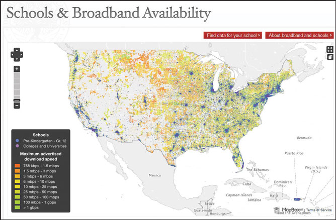
Broadband availability for U.S. schools.
From Collection To Publication
The Map meets the requirements of the Recovery Act’s
mandate, complementary White House initiatives, and the needs of
potential users. The Recovery Act required that the final product be
comprehensive, interactive, and searchable, and display broadband
service capability and availability. Consistent with the White House
Open Government Initiative, the team also incorporated transparency,
participation, and collaboration as necessary elements for a successful
final product. With these core requirements in place, staff then
considered who would use the product and designed the requirements for
the National Broadband Map platform based on the needs of those
potential users.
Stakeholder feedback underpinned the development of use cases for
distinct groups and important website functionality. For example,
policymakers represent one stakeholder group. Consumers and small
businesses represent two others. Stakeholders also expressed an
expectation to see their search queries quickly and in a digestible
format. After reviewing these needs, NTIA and the FCC identified three
core functions: search, analyze, and map. A consumer is able to search
broadband options at a neighborhood level (in the case of the Map, a
neighborhood equates to a census block or road segment). A researcher
or an economic developer analyzes the data and is able to determine
where his community ranks in comparison to similar areas. A policymaker
is able to view maps that tell the story of broadband availability both
across the entire country and at a granular level.
The openness and transparency of the data and process, both to drive
use and to ensure accountability, align this project with the White
House Open Government Initiative. While the final product allows users
to view broadband data in the context of demographic information, and
across multiple political boundaries, the Federal team expected that
stakeholders would have additional uses for the data. For this reason,
the entire National Broadband Map is available through 37 application
programming interfaces (APIs) (www.broadbandmap.gov/developer) and through
a download (www.broadbandmap.gov/data-download). These
tools allow developers to leverage the data and allow researchers to
analyze the data in innovative ways. Moreover, the complete technical
process that the FCC and its contractors implemented to assemble the 25
million records provided by grantees into a geospatial dataset that
could meet the program’s needs are fully detailed on the Map’s
Technical Overview page (www.broadbandmap.gov/about/technical-overview).
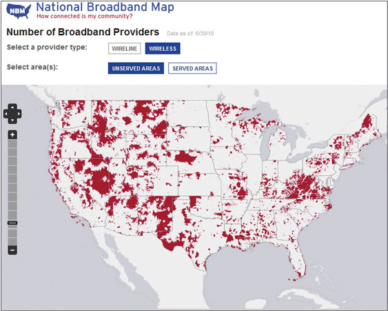
National Broadband Map showing the number of providers.
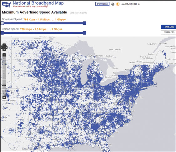
National Broadband Map showing maximum advertised speed available.
What’s Next?
In only the first few months, more than 500,000 unique
visitors used the website. On average, they stayed for over 10 minutes.
Federal and private sector groups are consuming APIs in exciting ways
and researchers and others have downloaded the data over 1,000 times
and are beginning to publish their findings. On September 21, 2011,
NTIA, in collaboration with the FCC, and using data that each State,
Territory, and the District of Columbia (or their designees) provided,
updated the National Broadband Map.
Collaboration between and among State governments, non-profit
organizations, Federal agencies, broadband providers, and many other
stakeholders helped bring the National Broadband Map to fruition. Every
partner in this project was committed to meeting the deadline set by
Congress. This support—and the agility demonstrated daily by so many of
the key partners and stakeholders—has been critical to the project
meeting its goals. States are currently funded to continue updating
their datasets through the end of 2014, and NTIA and the FCC plan to
continue working together to update the National Broadband Map website
twice a year with new data from grantees. Through its collaboration
with State and other Federal agencies, the National Broadband Map team
will continue to make the project a vibrant example of the
NSDI.
State of the Standards
Survey of Standards Usage
Standards facilitate the development, sharing, and use of
geospatial data. The FGDC develops geospatial data standards for
implementing the National Spatial Data Infrastructure, in consultation
and cooperation with State, local, and Tribal governments; the private
sector and academic community; and, to the extent feasible, the
international community. The FGDC develops geospatial data standards
only when no equivalent voluntary consensus standards exist, in
accordance with Office of Management and Budget (OMB) Circular A–119 on
Federal Participation in the Development and Use of Voluntary Consensus
Standards and in Conformity Assessment Activities.
In 2011, the FGDC conducted its first survey on FGDC member agency use
of FGDC-endorsed standards and requirements for standards. Fifteen FGDC
member agencies from 11 of the 31 FGDC Departmental level members
provided complete responses to the survey. It should be noted that
agencies need to use only the standards applicable to their mission
areas. A select subset of the survey results are presented
here.
Agency Policies on Standards
Survey results show that 11 FGDC member agencies (73 percent of respondents) have developed internal guidance on geospatial standards that are applicable for their use. Three responding agencies (20 percent) reported that their agencies have not identified standards that are applicable for their use.
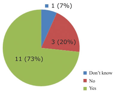
Graphic showing number of responding agencies
that have identified standards for agency use.
The survey queried FGDC member agencies on whether they measured compliance with standards. Seven agencies reported that they measure compliance with standards, while an equal number reported that they do not measure compliance with standards.
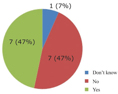
Graphic showing number of responding agencies
that measure compliance with standards.
Use of Standards
The survey queried FGDC member agencies on their use of 100
FGDC-endorsed standards, including the 64 externally developed
standards that the FGDC endorsed in 2010 in support of the Geospatial
Platform.
Table 1 lists the ten standards with the highest level of use, based on
responses. As metadata is key to geospatial data sharing through data
documentation, discovery, and determining applicability of use, it is
not surprising that it ranks as the standard of highest use.
Table 2 identifies the five standards with the highest number of
planned implementations. Since the processes and tools to migrate to
the International Organization for Standardization (ISO) metadata
standard are currently a hot topic, it is not surprising to see it
ranking as the number 2 “plan to use” standard.
The FGDC-endorsed standards usage survey is intended to become an
annual reporting mechanism aligning with the broader OMB Circular A–16
Supplemental Guidance implementation of geospatial data portfolio
management and reporting. This year’s responses will serve as an
initial baseline for future standards usage reporting.
| Standard | Number (Percentage) of responding FGDC member agencies that use the standard | |
|---|---|---|
| 1. | Content Standard for Digital Geospatial Metadata (version 2.0) | 12 (80.0%) |
| 2. | Geospatial Positioning Accuracy Standards, Part 3: National Standard for Spatial Data Accuracy | 9 (60.0%) |
| 3. | Classification of Wetlands and Deepwater Habitats in the United States | 8 (53.33%) |
| 4. | Geospatial Positioning Accuracy Standards, Part 1: Reporting Methodology | 8 (53.33%) |
| 5. | INCITS 455:2009, Information Technology - Codes for the Identification of Congressional Districts and Equivalent Areas of the United States, Puerto Rico, and the Insular Areas | 7 (46.67%) |
| 6. | OpenGIS (OGC) KML (version 2.2.0 | 7 (46.67%) |
| 7. | National Vegetation Classification Standard (version 2) | 7 (46.67%) |
| 8. | Part 6, Hydrography, FGDC-STD-014.6-2008 | 7 (46.67%) |
| 9. | GeoTIFF Revision 1.0 | 7 (46.67%) |
| 10. | Content Standard for Digital Orthoimagery | 6 (40.0%) |
| Standard | Number (Percentage) of responding FGDC member agencies that plan to use the standard | Number (Percentage) of responding FGDC member agencies that are using the standard | |
|---|---|---|---|
| 1. | United States Thoroughfare, Landmark, and Postal Address Data Standard | 7 (46.67%) | 4 (26.67%) |
| 2. | INCITS/ISO 19115:2003 [R2008] ISO 19115:2003 w/ISO 19115 Cor. 1:2006, Geographic information - Metadata + Corrigendum 1 | 6 (40.0%) | 0 (0.0%) |
| 3. | OpenGIS (OGC) Web Map Service Implementation Specification (version 1.3.0) | 5 (33.33%) | 5 (33.33%) |
| 4. | Cadastral Data Content Standard | 5 (33.33%) | 4 (26.67%) |
| 5. | INCITS 453: 2009, Information technology - North American Profile of ISO 19115:2003 - Geographic information - Metadata (NAP - Metadata) | 5 (33.33%) | 5 (33.33%) |
FGDC Response to NIST Request for Information
The FGDC responded to a Request for Information (RFI) from
the National Institute of Standards and Technology (NIST) on
“Effectiveness of Federal Agency Participation in Standardization in
Select Technology Sectors for the National Science and Technology
Council’s Sub-Committee on Standardization” that was published in the
Federal Register. In this RFI, NIST invited interested parties to
provide their perspectives on the effectiveness of participation by
Federal agencies in the development and implementation of standards and
conformity assessment activities and programs.
In its response to the RFI from NIST, the FGDC noted that it uses
voluntary consensus standards, as defined in OMB Circular A–119, in
lieu of government-unique standards whenever possible. In 2010, the
FGDC endorsed 64 external standards, many of which were voluntary
consensus standards.
The FGDC emphasized its participation in the InterNational Committee on
Information Technology Standards Technical Committee L1 (INCITS L1),
Geographic Information Systems; International Organization for
Standardization (ISO) Technical Committee 211, Geographic
information/Geomatics; the Open Geospatial Consortium, Inc. (OGC); and
the Geospatial-Intelligence Standards Working Group (GWG). By
participating in these standards bodies, the FGDC leverages the
knowledge, skills, and talent of the geospatial community in the
development of standards that enable information, data, and service
interoperability.
The FGDC, in its response to the RFI, identified factors that hinder
participation in standardization activities and (or) the adoption and
use of standards:
- ISO and the American National Standards Institute (ANSI) charge a fee for standards. It is difficult to promote the adoption of standards when State and county agencies and local and Tribal governments are obliged to purchase standards, even if they were involved in their development and (or) review.
- Voluntary consensus standards often have copyright restrictions that negatively affect their promulgation and use. Nonetheless, OMB Circular A–119 directs Federal agencies to “observe and protect the rights of the copyright holder and any other similar obligations.”
- Federal agencies have limited resources to commit to standardization activities. The return on investment for standardization activities is often a long-term outcome. The priority level for standardization activities is reduced when agencies need to show short-term benefits.
- The Federal civilian community needs better incentives to adopt standards. The FGDC noted that one disincentive to adopting and using standards is the current lack of a mechanism to enforce the use of standards.
More information on the RFI is available at: www.nist.gov/director/sco/index.cfm (search on “SOS RFI Comments Summary”).
FGDC Advances the National Spatial Data Infrastructure
The Geospatial Line of Business Advances
Priorities for the Geospatial Line of Business in fiscal
year 2011 have been to (1) increase the Federal Government’s return on
investment for geospatial data and technology, (2) increase the ability
of Federal agencies to utilize existing geospatial data from Federal
and non-Federal partners, (3) increase the Federal Government’s ability
to utilize high-value geospatial data for decisionmaking in a timely
manner, and (4) provide a platform for the service and use of common
geospatial data, applications, and services.
These goals are being met through the continued cross-agency
development of a Federal geospatial asset portfolio management
capability, as outlined in the “Geospatial Line of Business, OMB
Circular A–16 Supplemental Guidance,” released by OMB November 10,
2010; and the development of the Geospatial Platform, as defined in the
“Modernization Roadmap for the Geospatial Platform,” March 2011; and
the ongoing drafting of the “Building the Business Case for the
Geospatial Platform, the Value Proposition” document. Many of the 2011
tasks have moved the FGDC toward the Phase I implementation of the
Geospatial Platform. The major efforts for the Geospatial Line of
Business have been OMB Circular A–16 Supplemental Guidance approval,
beginning portfolio management implementation, and planning and initial
implementation of the Geospatial Platform. These efforts demonstrate
forward movement in how we do business for geospatial activities. Below
is a summary of each effort and highlights of accomplishments.
The Circular A–16 report cover.
Geospatial Line of Business Accomplishments
|
A–16 Supplemental Guidance Endorsed
The 2011 endorsement of the OMB Circular A–16 Supplemental Guidance document by the Office of Management and Budget provides definition and clarity to selected elements of OMB Circular A–16 to help facilitate the adoption and implementation of a coordinated and effective Federal geospatial asset management capability. This management capability improves support of mission-critical business requirements of the Federal Government and its stakeholders. The Supplemental Guidance primarily focuses on geospatial data as capital assets and provides the foundation for a portfolio management approach to a National Geospatial Data Asset (NGDA) Portfolio comprised of NGDA Themes and their associated NGDA Datasets.
Portfolio Management Begins Implementation
A key tenant of the Circular A–16 Supplemental Guidance is
having an understanding of the inventory of NGDA datasets. The
development of the current NGDA inventory affords NGDA Theme Leads the
opportunity to review, validate, and evolve those data assets for which
their organizations hold stewardship responsibilities. In order to
effectively show how the NDGAs support the business requirements of the
Federal Government and its partners, the data inventory needs to
compare characteristics such as content, quality, application,
validity, and definition in order to have a consistent process for
determining the data that belongs in the inventory. This initial NGDA
inventory activity identified a baseline portfolio in support of an
emerging full portfolio management process.
The portfolio management implementation strategy serves as a guide for
the actions needed to reach full management of the portfolio of NGDA
datasets. A phased approach for achieving full implementation includes
continual improvements and annual reporting on progress. Each phase
supports the outcomes identified in the OMB Circular A–16 Supplemental
Guidance. The portfolio management process consists of six stages:
inventory, selection, organization, management, evaluation, and
monitoring. This process also includes the setting of Federal
geospatial dataset priorities to ensure that NGDA Datasets are
available to support the mission needs of the Federal Government and
its partners, as determined by Federal agencies and their partners and
as recommended to OMB.
The Geospatial Platform Initiative
Geospatial assets are an integral part of government and private day-to-day operations. While the business needs of stakeholders vary, different operations often require the use of similar assets. Coordinating the development and integrated use of the Nation’s geospatial assets is a complex effort, but the geospatial community has come together to create an initiative—the Geospatial Platform—to promote improved coordination and more effective use of geospatial information. The Geospatial Platform is designed to leverage geospatial expertise and existing geospatial data, services, applications, and infrastructure from across the government to enhance the Nation’s utilization of geospatial resources. The Geospatial Platform is an Internet-based capability providing shared and trusted geospatial data, services, and applications for use by government agencies and partners to meet their mission needs and for use by the public and provides opportunities to view and conduct business in new and innovative ways.
The Geospatial Platform will function as the service and delivery mechanism for the Federal portfolio of geospatial data, applications, and services, and as the integration point for the discovery, access, and joint use of Federal and non-Federal geospatial data and services. The accomplishments for the year include:
|
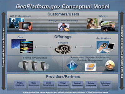
The Geospatial Platform conceptual model.
Geospatial One-Stop Migrating to Data.gov
The Geospatial One-Stop (GOS) portal and catalog continued
to be a central resource for inventory of geospatial assets in the
United States in support of the Geospatial Line of Business and the
National Spatial Data Infrastructure (NSDI). The catalog and data
visualization capabilities of GOS are also identified as key components
of the technical solutions in the proposed Geospatial Platform Version
0 and Version 1 implementations. Federal, State, local, academic, and
Tribal data and service resources are registered through individual
metadata entries. The holdings of the GOS database grew substantially
in fiscal year 2011. With more than 678,000 individual metadata records
contributed by 450 publishers, this is a 52-percent increase in records
from fiscal year 2010. The National Oceanic and Atmospheric
Administration, U.S. Census Bureau, and U.S. Geological Survey were the
main contributors of these additional records. The significant increase
in the number of records in the GOS database continued to be driven by
the integration of GOS with Data.gov. The GOS metadata catalog plays a
central role in the population of Data.gov, now contributing both Federal and
non-Federal geospatial assets. In all, over 391,000 records are shared
from GOS with Data.gov, which means that 90 percent of the
records available in Data.gov are geospatial data from GOS. This
is a good example of how shared and integrated capabilities can
increase governmental transparency and efficiency.
The GOS team continued to work with Federal agencies to promote
collections of records through GOS for discovery in Data.gov. Several
large collections of metadata were added to GOS/Data.gov, supplementing
additions from the U.S. Census Bureau, the U.S. Environmental
Protection Agency, and other agencies. These include US Topo (the next
generation of digital topographic maps from the U.S. Geological
Survey), high-resolution aerial orthoimagery from the U.S. Geological
Survey, and Shuttle Radar Topography Mission data from the National
Geospatial-Intelligence Agency and the National Aeronautics and Space
Administration.
The GOS portal began its integration with Data.gov during fiscal year 2011, and this
transition is expected to be complete in fiscal year 2012. At that
time, Data.gov
will become the official means for accessing metadata resources managed
in the NSDI Clearinghouse Network. The goal is to create an integrated
system to catalog and provide access to geospatial and non-geospatial
data and services and to support the existing requirements and
objectives of NSDI and the Geospatial Platform. Content has been
migrated from the GOS catalog to a new repository integrated with Data.gov at the U.S.
General Services Administration. This forms the basis of metadata
management and search for the NSDI. The integration task will also
provide the initial capabilities required for the Geospatial Platform
activity—cataloging, visualization, and access to remote (agency) and
common services, and leveraging cloud-based and agency-hosted data and
services.
Once the GOS metadata collection is migrated to Data.gov, Data.gov will
include more than just the Federal, downloadable datasets that are
currently available. Data.gov will utilize the catalog for search
and access to Federal validated data, and the Geospatial Platform will
utilize the catalog for search and retrieval of Federal and non-Federal
records and registered services. Geospatial data visualization
capabilities in Data.gov will be enhanced and a geospatial
data search capability will be added. In these ways, Data.gov will
encompass and extend much of the functionality that was formerly
available through the GOS portal.
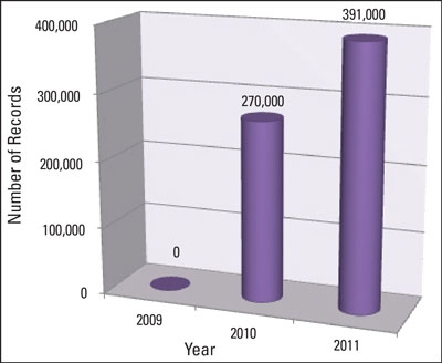
Graphic showing the number of records shared by
Geospatial
One-Stop (GOS) with Data.gov.
GeoCloud Sandbox Initiative
The GeoCloud Sandbox Initiative is an FGDC–General Services Administration sponsored activity to develop geospatial application server software packaging that can be used in the Cloud environment. The FGDC Technology and Architecture Working Group sought Federal participants with application server software who are interested in prototyping deployment of public geospatial data and service offerings in a Cloud environment for up to one year.The objective of the GeoCloud Sandbox Initiative is to provide technical assistance; external hosting monitoring; and reporting on configuration options, results, usage, and costs for mission-critical geospatial data and software within a Federal cloud-computing environment. Key items addressed in fiscal year 2011 were:
- identifying requirements-driven solution architectures (comprehensive software environments) for variously sized deployments of geospatial data and services;
- documentation and cost analysis to support scalability, reliability, and redundancy;
- addressing system security concerns to expedite Federal Information Security Management Act (FISMA) certification and accreditation for agency adoption; and,
- supporting and collecting cost comparison information from agencies for existing and externally hosted Cloud solutions.
| Accomplishment of the GeoCloud Sandbox
Initiative Amazon Cloud services are being used in the GeoCloud Sandbox Initiative to support both open source and commercial geospatial application servers for nominated FGDC member agency projects. Benefits of the Cloud include scalable capacity, performance, shared system security profiles, reduced time to deploy, and manageability though variable monthly costs of operation. Projects range from small to large and project experience can be shared and applied by other agencies. |
Ten projects were identified within the U.S. Census Bureau,
U.S. Department of Agriculture, U.S. Environmental Protection Agency,
U.S. Fish and Wildlife Service, U.S. Geological Survey, and National
Oceanic and Atmospheric Administration. These projects were typically
existing, public-facing Web service environments that included standard
geospatial software for access and (or) analysis. By starting with
existing systems, a fair comparison of in-house and cloud-hosting costs
and procedures can be made. Through the redeployment of certified
systems, the system security approval process can be accelerated. By
sharing common packages of software, agency projects can share the
“platform” certification burden and accelerate deployment times, adding
in only their data and minor customization.
Two geospatial “platform as a service” environments (also known as
reference platforms) were developed based on the requirements of the
participating projects. Common software and operating systems were
identified to create the reference platforms in order to maximize
re-use. An open-source reference platform includes Linux (CentOS),
Apache, MySQL, PostgreSQL, Java, Tomcat, OpenGeo’s GeoServer, and
GeoNetwork products. The commercial reference platform includes Windows
2008 Server R2, IIS, Java, Tomcat, and Esri ArcGIS Server, and related
programming environments. Installation scripts were written using the
Amazon CloudFront technology that enables projects to rapidly configure
and deploy virtual machines in Amazon. Periodic assessments of
dependencies between the software packages were made, resulting in
adjustments to the versions and installation scripts.
The U.S. Census Bureau deployed its 2009 TIGER Line file server using
the Linux CentOS image, offering an enhanced ftp/http data access
service for all public access to 2009 TIGER data. In the Windows
environment, the key system deployed was the Wetlands Mapper
Application using the ArcGIS Server, developed by the U.S. Fish and
Wildlife Service and deployed by the U.S. Geological Survey information
technology staff. Performance and reliability of the deployed services
in both cases was comparable or superior to the legacy service
environment in the agency data centers. Additional configuration
capabilities exist in the Cloud environment for load balancing and to
automatically scale additional service capacity in times of high
demand.
The most challenging aspect of migration to the Cloud has been
acquiring agency security approval for the Cloud applications. In most
cases, the existing agency system security approval (Certification and
Accreditation - C&A) was used as a basis for a Cloud C&A, but
the hosting infrastructure, interconnect agreements, and service-level
agreements desired by the agencies were sometimes difficult to document
or acquire in order to issue an Authority to Operate (ATO). These
infrastructure-based security issues are being addressed through
GeoCloud use of the recently GSA-approved Infrastructure as a Service
(IaaS) Blanket Purchase Agreement for Cloud services, acquired through
Apps.gov. This has provided a Federal-wide security approval for the
IaaS solutions that agencies can accept and incorporate into their
systems-accreditation process.
National Geospatial Advisory Committee Promotes Communication
The National Geospatial Advisory Committee (NGAC) is a
Federal advisory committee sponsored by the Department of the Interior
to provide external advice and recommendations to the member agencies
of the FGDC. The NGAC includes 28 committee members representing a
variety of organizations involved in geospatial issues, at all levels
of government, the private sector, non-profit organizations, and
academia. The list of members is available at www.fgdc.gov/ngac.
The NGAC meets three to four times per year and has established
subcommittees that conduct research and develop draft products between
committee meetings.
The NGAC promotes two-way communication on issues of common interest to
the national geospatial community and provides a forum to convey views
representative of our partners and stakeholders. The NGAC has served as
a valuable source of advice and feedback for the FGDC. Over the past
year, the NGAC has analyzed and provided recommendations on a number of
key geospatial policy issues. Highlights of the NGAC’s 2011 activities
include the following:
- The NGAC developed recommendations on several important topics in 2011, including the Geospatial Platform Initiative, The National Map, geolocation privacy, the National Land Imaging Program, Transportation for the Nation, and the Federal Aviation Administration’s laser pointer issue, which could impact the collection of LiDAR data.
- The NGAC adopted an Action Plan for committee activities in 2011/2012, including goals and subcommittees organized under the following areas:
-
- Innovative Strategies for Geospatial Programs and Partnerships
- Geospatial Platform
- Geospatial Workforce Development
- Emerging Technologies
- Geospatial Partnerships with Tribal Governments
- The NGAC also designated Points of Contact (POCs) for significant Federal geospatial programs and initiatives. The role of the POCs is to monitor program activities and keep NGAC members informed of key developments.
- The NGAC engaged in a dialogue with FGDC Chair Anne Castle regarding the White House budget initiative for the National Land Imaging Program and adopted the following resolution:
-
“The NGAC strongly supports the establishment of the National Land Imaging Program as described in the Administration’s fiscal year 2012 budget proposal and we encourage the Department of the Interior to implement the program as soon as possible. NGAC looks forward to providing advice to the Department on the development and implementation of the program. This recommendation is made in the context of a more comprehensive multi-agency, multi-resolution, multi-sensor imagery program for the nation.” - The NGAC adopted a paper on local government GIS best practices.
- The NGAC adopted a paper on best practices for interagency data sharing.
- The NGAC held a series of “spotlight sessions” that brought together experts on key topics to discuss new approaches and identify best practices and lessons learned. The spotlight sessions focused on the topics of interagency data sharing, geospatial workforce development, and national land parcel data.
| NGAC Leadership Transition In February 2011, Secretary of the Interior Ken Salazar appointed a new Chair and Vice Chair to lead the NGAC. Dr. David Cowen, Professor Emeritus of Geography at the University of South Carolina, was appointed as NGAC Chair. Dr. Jerry Johnston, the Geospatial Information Officer at the U.S. Environmental Protection Agency, was appointed as Vice Chair. Dr. Cowen and Dr. Johnston are well-known and respected leaders in the geospatial community, and they bring a wealth of experience and expertise to their new leadership roles. The new leadership team replaces the outgoing Chair and Vice Chair, Anne Hale Miglarese of Booz Allen Hamilton and Steven Wallach, recently retired from the National Geospatial-Intelligence Agency. Ms. Miglarese and Mr. Wallach served with distinction as the first leadership team for the NGAC to establish the NGAC as a trusted voice for the geospatial community.  |
Standards Progressing Forward
United States Thoroughfare, Landmark, and Postal Address Data Standard
In February 2011, the FGDC Steering Committee endorsed the
United States Thoroughfare, Landmark, and Postal Address Data Standard
(“Address Data Standard”). The standard contains four parts: address
data content, classification, transfer, and quality.
Street addresses, which are covered by the Address Data Standard, are
the location identifiers most commonly used by various levels of
government and the public. Street addresses are critical for
administrative records, emergency and first response, research,
marketing, mapping, geospatial information systems, routing and
navigation, and law enforcement. The standard provides Federal, State,
local, and Tribal agencies with a means to share address information,
as well as a methodology for improving response to emergency and
non-emergency service requirements, with associated improvements in
efficiency, effectiveness, and economy.
“The United States Thoroughfare, Landmark, and Postal Address Data
Standard will have a significant impact at all levels of government and
is an essential component of the National Spatial Data Infrastructure,”
said Ivan DeLoatch, Executive Director of the FGDC. “We encourage
government agencies, as well as others, to implement the standard for
it provides a foundation for understanding and developing solutions for
the many challenges in our communities.”
The U.S. Postal Service (USPS) and the National Emergency Number
Association (NENA) were involved in the development of profiles for the
Address Data Standard. The “Postal Addressing Profile of the Federal
Geographic Data Committee United States Thoroughfare, Landmark, and
Postal Address Data Standard” outlines the equivalencies and
differences between the Address Data Standard and USPS Publication 28,
“Postal Addressing Standards.” Similarly, the “Profile Reconciling the
FGDC United States Thoroughfare, Landmark, and Postal Address Data
Standard” and the NENA’s “Next Generation 9-1-1 (NG9-1-1) Civic
Location Data Exchange Format (CLDXF) Standard” outline equivalencies
and differences between the two standards. The FGDC awarded Spatial
Focus, Inc. a 2011 National Spatial Data Infrastructure Cooperative
Agreements Program (NSDI CAP) grant for prototyping data quality and
data exchange tools to assist government agencies in implementation of
the Address Data Standard.
Coastal and Marine Ecological Classification Standard
Coastal and marine planners and managers are faced with
complex challenges when making decisions about habitat conservation and
resource management. Given this complexity, and recognizing the
vastness of the marine environment for which the United States has
jurisdiction, the requirement for a standard national classification
for coastal and marine systems was identified. To fulfill this
requirement, the National Oceanic and Atmospheric Administration and
NatureServe developed the Coastal and Marine Ecological Classification
Standard (CMECS). CMECS is relevant to all U.S. coastal and marine
environments and can be applied locally, regionally, nationally, and
even globally. A standardized approach enables coastal and marine
planners and managers to develop strategies for resource management and
conservation for all of North America’s coasts and oceans.
CMECS was released for public and peer review in 2010. The FGDC awarded
a 2011 NSDI CAP grant to NatureServe to support resolution of comments
from public and peer review and production of a final draft. A final
draft CMECS is expected in December 2011.
| Return on Geospatial Investment: Iowa LiDAR
Project The State of Iowa is seeing many benefits and savings from its LiDAR elevation project and from freely sharing the data with city, county, State, and Federal agencies and private engineering firms. Business benefits and cost savings have been seen in numerous areas, including reducing the cost of planning topographic surveys for construction projects, county planning for wind farm and industrial siting, city water and sewer improvement projects, and emergency and disaster management. These benefits and savings are backed up by a recent Return on Investment study completed by the Iowa Geographic Information Council and utilized components of the FGDC Return on Investment methodology developed through the Cooperative Agreements Program. The study showed an estimated benefit of $5 million per year. Here are several examples of how free LiDAR data provides benefits and saves time and money.
|
Federal Trails Data Standard
In 2011, the FGDC Steering Committee endorsed the Federal
Trails Data Standard for FGDC endorsement. Governmental agencies and
the public recognize trails as important recreational and cultural
resource corridors. The National Park Service, the Bureau of Land
Management, U.S. Fish and Wildlife Service, and U.S. Forest Service
have worked with each other and with States, local governments, and
trail organizations for many years to promote and develop trails for
the benefit of the public.
Trail information is a necessity throughout the trails management
lifecycle, from planning through design, construction, operation, and
maintenance. The U.S. National Park Service, Bureau of Land Management,
U.S. Fish and Wildlife Service, and U.S. Forest Service developed the
Federal Trails Data Standard to facilitate the access, exchange, and
use of trail information and increase the capability for enhanced and
consistent trails mapping, inventory, monitoring, condition assessment,
maintenance, costing, budgeting, information retrieval, and summary
reporting.
Geospatial-Intelligence Standards Working Group
The FGDC recognizes the need for common standards across the
defense, intelligence, and civilian communities, as these communities
establish a common operating environment. The FGDC is a member of the
Geospatial-Intelligence Standards Working Group (GWG) chaired by FGDC
member agency the National Geospatial-Intelligence Agency. The GWG
provides a consensus-based community forum authorized to prescribe and
mandate geospatial standards for use by Federal Government
organizations within the Department of Defense and the intelligence
community. The FGDC is the GWG’s link to the civilian community. In
2011, the FGDC worked to develop a standards review and approval
process to align with the process used by the GWG so that there will be
common standards among the defense, intelligence, and civilian
communities.
Geospatial Metadata: Workhorse of the NSDI
Metadata continues to be a fundamental component of NSDI
initiatives across the board. Metadata records published though the
Geospatial One-Stop (GOS) portal comprise the majority of Federal
records within Data.gov. As the transition from GOS to Data.gov as a
catalog for the Geospatial Platform progresses, the FGDC will continue
to provide a venue for non-Federal records in support of data sharing
among the broader NSDI community within an integrated catalog shared
with Data.gov.
Data sharing is increasingly recognized as a GIS best practice by NSDI
stakeholders, and much of the 2011 effort was focused on supporting the
National Science Foundation (NSF) DataONE data sharing effort and the
National States Geographic Information Council (NSGIC) Data Sharing
Working Group.
Metadata is also fundamental to data development in compliance with
Framework and other spatial data standards. The NSDI Cooperative
Agreements Program (NSDI CAP) sponsored the development of data and
metadata that demonstrate the application of the recently approved
United States Thoroughfare, Landmark, and Postal Address Data Standard.
Products from the NSDI CAP project will serve as examples for use by
NSDI stakeholders as they implement the standard.
With an eye to the future, focus is also directed toward the
challenges, tools, and processes for migrating from the FGDC’s Content
Standard for Digital Geospatial Metadata to the International
Organization for Standardization (ISO) Geographic Information –
Metadata standard. Planning is underway for a Metadata Summit that will
bring together a group of metadata subject matter experts to identify
challenges and opportunities presented by the new metadata standard and
to begin identifying strategies for effective implementation.
Cooperative Agreements Program Builds the NSDI
To encourage and enable building the NSDI at all levels of
the geospatial data community, the FGDC sponsors the Cooperative
Agreements Program (CAP). The benefits to the community are not only
financial but more importantly validate an organization’s geospatial
endeavors, which leads to new opportunities. The CAP has created
collaborations within all sectors of government, helped develop an
understanding of geospatial information in organizations new to the
NSDI, provided seed money to enable geospatial organizations to
participate in the national effort to implement the NSDI, promoted the
importance of geospatial data standards, promoted the development of
standardized metadata in hundreds of organizations, and greatly
expanded implementation of geospatial services on the Internet.
The program’s diversity can be seen in the 27 CAP projects completed
this year. The GeoCommons platform was extended to enable it to
dynamically georeference Federal Government tabular data, which will
allow data to be discovered, accessed, and applied in its geographic
context; Geocommons.com. Four projects developed client/server-mediated
applications that can access, search, and exploit the geospatial data
and services referenced by the Geospatial One-Stop portal to support
specific geographic or discipline requirements. For more information
see www.fgdc.gov/grants/2009CAP/2009CAPDescriptions#category2.
Illinois, Indiana, and Missouri created or enhanced numerous
partnerships between regional and local governments and demonstrated
viable solutions to solve data interoperability problems. Projects in
Alaska, Michigan, Montana, and Utah focused on building data
stewardship for transportation geospatial information. Complete guides
to the National Vegetation Classification Standard (Version 2) were
developed for online and classroom use; mtnhp.org/ecology/nvcs/. Finally, the CAP
continued to sponsor projects that serve to train a variety of interest
groups in the value of metadata and in its implementation and sharing.
This year over 141 people were introduced to metadata concepts though a
variety of workshops and online and in-person presentations.
In the 2011 program, CAP awards were given to 20 projects that address
six categories. The planned CAP budget for fiscal year 2012 is just
over $800,000, and these funds will be used to support up to 41
projects. For more information, please see www.fgdc.gov/grants.
| Feedback on the NSDI CAP Montana: “[The program] improves the quality of data available at the national level by facilitating the movement of local authoritative data to the State, then to the national level. It also helped to foster relationships with local data providers and emphasize the importance of data sharing which in turn benefits the Federal level.” |
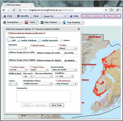
Kenai Peninsula Borough, Alaska, Parcel Viewer showing the
road notes application,
www.borough.kenai.ak.us/GISDept/AGS.html.
Fifty States Initiative Promotes Coordination
This year marked the sixth anniversary of the Fifty States
Initiative. The Initiative strengthens statewide coordination by
advancing strategic and business plans and helps identify activities
where strategy for Federal partnerships can and should occur. Since
2006, 48 States plus the District of Columbia and the U.S. Virgin
Islands have received support through the NSDI CAP program. In 2011,
eight States (Delaware, Hawaii, Idaho, Kentucky, Maine, Michigan,
Mississippi, and Oregon) plus the U.S. Virgin Islands completed
Initiative projects and ten awards were given to projects in
California, Florida, Idaho-Montana (joint project), Louisiana,
Minnesota, New Jersey, Tennessee, Utah, West Virginia, and
Wisconsin.
This year’s “Measuring Progress of the Fifty States Initiative” status
report noted that NSDI CAP helps to formalize efforts toward and
improvement of statewide coordination, communication, and collaboration
among stakeholders. In addition, States that have plans in place were
in a better position to compete for American Reinvestment and Recovery
Act (ARRA) funds that furthered their geospatial capabilities and their
contributions to national level data. As the Fifty States Initiative
continues into its seventh year, the emphasis will be on furthering
business planning and the plan implementation process that helps States
forge key partnerships. For more information about the Initiative,
please see www.fgdc.gov/policyandplanning/50states.
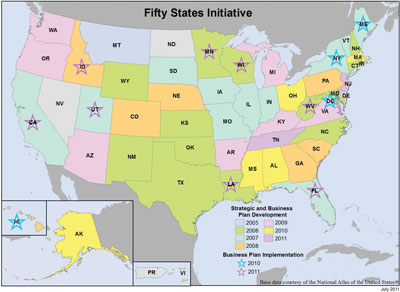
Map showing status of the Fifty States Initiative at the end
of
fiscal year 2011.
International Activities Progressing
The FGDC Secretariat continues to support international
efforts through the Global Spatial Data Infrastructure (GSDI)
Association and the intergovernmental Group on Earth Observations.
These activities are underpinned by the adoption of common techniques
and standards to promote interoperability worldwide and thereby
facilitate access to geospatial data and services.
The FGDC supports the GSDI Association efforts to increase
international collaboration on spatial data infrastructure (SDI)
development. In support of this, the FGDC coordinates and supports the
GSDI Small Grants Program that promotes SDI adoption in developing
countries around the world. In 2011, fourteen projects were supported.
The GISCorps of Urban and Regional Information Systems Association
partners in the GSDI Small Grants Program and provides professional
services in support of this effort. Through the GSDI Association, FGDC
funds the publication of regional SDI newsletters. In addition, the
FGDC hosts a visiting scientist from Korea who supports the Asia
Pacific regional newsletter and other GSDI activities.
The FGDC Secretariat continued support for the intergovernmental Group
on Earth Observations (GEO) and its Global Earth Observation System of
Systems (GEOSS). In fiscal year 2011 the Secretariat supported the
revision of the 2012–2015 workplan and committee structure. Ivan
DeLoatch, FGDC Secretariat Executive Director, is a co-chair for the
Architecture and Data Committee, and Doug Nebert, FGDC Secretariat
Senior Advisor for Geospatial Technology, is Task Lead for the key
architectural task (AR-09-01A) within GEO. The FGDC and U.S. Geological
Survey developed and continue to operate and evolve core catalog
service capabilities for GEOSS—the GEOSS Clearinghouse and Component
and Service Registry—through technical support agreements with George
Mason University. Significant enhancements to the capability of GEOSS
were developed for presentation to the GEO Plenary Session in November
2011.
GeoCircle is a new website that facilitates communication about geospatial issues. It allows Native American Tribes to connect with the Department of the Interior (DOI). GeoCircle allows users to share information about:
The FGDC is proud to support GeoCircle and provides information on FGDC activities and opportunities of interest to the GeoCircle community. |
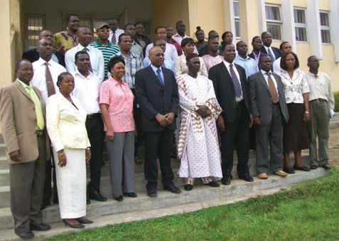
West Africa SDI Workshop, Obafemi Awolowo University Campus, Ile-Ife, Nigeria.
NSDI Training Expands Beyond Metadata
FGDC continues to work with stakeholders to develop a range
of NSDI-related training materials. A cooperative agreement with the
University of Wyoming resulted in the development of a full suite of
NSDI Framework Data training materials that go beyond basic
presentation slides by including links to resources, an audio track,
quizzes, and other dynamic features. The materials are available from
the NSDI Online Training Program website (www.fgdc.gov/training/nsdi-training-program/online-lessons#lessons).
FGDC supports the National Science Foundation (NSF) DataONE program
efforts to develop training materials that encourage and guide
scientists in best practices for sharing research data within their
scientific communities and with the public. The materials are being
developed through the DataONE Community Engagement and Education
Working Group and will be available from the DataONE website (www.dataone.org) once completed.
Metadata remains the most commonly requested NSDI training topic. FGDC
partnered with the U.S. Geological Survey National Biological
Information Infrastructure (NBII) program to lead a metadata ”Train the
Trainer” workshop for the Bureau of Land Management. FGDC also
partnered with the National Oceanic and Atmospheric Administration’s
National Coastal Data Development Center (NCDDC) to provide
introductory metadata training to coastal partners in State and local
governments and their private-sector associates. Through the
Cooperative Agreements Program, FGDC supported university, Tribal, and
private-sector stakeholders in developing and delivering metadata
training workshops for State, local, and Tribal communities.

The geospatial metadata ”Train the Trainer” workshop, held
in Portland, Oregon, was
targeted toward Federal data managers who have an interest in expanding
metadata
implementation and training within their own operations.
FGDC Subcommittee and Working Group Reports
The FGDC currently has nine subcommittees that form
communities of interest for nine data themes. In addition, four FGDC
working groups crosscut the subcommittees and focus on infrastructure
issues common to or supporting many of the NSDI data themes. Federal
agencies lead and have responsibility for the thematic subcommittees
and working groups. Below are the subcommittee and working group
high-level summaries of this year’s activities. Additional information
is available at www.fgdc.gov/participation.
Cadastral Subcommittee
- The FGDC Subcommittee for Cadastral Data continued to provide updates to the existing national inventory (www.gisinventory.net) of cadastral data. Almost all the States now have an identified State Cadastral Coordinator and many States have assumed responsibility for sustaining the inventory of local contacts.
- Updated sets of parcel data were provided to the wildland fire community, and efforts to establish sustainable standardized parcel datasets at the State level built on last year’s efforts. The States of Arizona, California, New Mexico, Nevada, and Washington made significant advances toward a sustainable system.
- The development of standardized Public Land Survey System (PLSS) datasets has been completed and updated in nine western States, and this data is being provided to the States as requested.
- The Federal Parcel Work Group completed the first draft of their report on the inventory of Federal and management agencies and a proposed core data standard for Federal land parcels.
Cultural and Demographic Statistics Subcommittee
- The United States Thoroughfare, Landmark, and Postal Address Data Standard was completed and adopted as an FGDC standard in February 2011.
Geodetic Control Subcommittee
- In fiscal year 2011, the subcommittee continued to engage its partners in its planning and preparation for the new geometric and geopotential datums. Two key subcommittee meetings were held that brought together representatives from 17 Federal agencies, 3 State offices, several private companies, and the National Society of Professional Surveyors. The overarching focus of those meetings was to plan and prepare for the datums of the future that will shift our Nation from a National Spatial Reference System (NSRS), defined by passive monuments, to a system based on observations of real-time Global Navigation Satellite Systems and measurement of the earth’s gravity field. Those changes will result in (1) profound improvements to the accuracy of the NSRS, and (2) enhanced access to the NSRS.
Geologic Subcommittee
- On behalf of the FGDC, the Digital Cartographic Standard for geologic maps continues to be supported by the U.S. Geological Survey National Geologic Map Database project. Collaboration with Esri has resulted in the release and subsequent update of a subset of the FGDC symbols, created as Cartographic Representations for use in ArcGIS. The Subcommittee is now planning for a significant update to the standard (pending available funding), to begin in late 2011. Guidance on the plan was sought from technical experts at the annual Digital Mapping Techniques (DMT) meeting in May 2011.
- A new database design for publication of geologic maps (“NCGMP09”) was proposed by the U.S. Geological Survey; the Subcommittee has begun evaluation of this and other designs, targeted at a Federal standard.
Marine and Coastal Spatial Data Subcommittee
- Member agencies of the Marine and Coastal Spatial Data Subcommittee were active participants in the development of the Coastal and Marine Spatial Planning National Information Management System (NIMS). This effort, led by staff from the National Ocean Council, included participation by 15 Federal agencies.
- Deployed phase two of the Multipurpose Marine Cadastre (MMC), a Web-based geospatial platform, that provides the baseline information needed for coastal and marine spatial planning efforts, particularly those that involve finding the best location for renewable energy projects and their permit review process. The Bureau of Ocean Energy Management was the first bureau to provide data content directly to the MMC via Web services.
- Subcommittee members continued to develop the Coastal and Marine Ecological Classification Standard (CMECS) and guide it through the FGDC Standards Approval Process.
National Digital Orthoimagery Program (NDOP) Subcommittee
The NDOP Subcommittee is responsible for developing a
national strategy for acquisition of orthoimagery data for Federal
agencies while creating and utilizing partnerships with State, local,
Tribal, and private organizations.
- Details for the two major NDOP programs, the National Agriculture Imagery Program (NAIP) and the Urban Areas Program, are contributed to by the U.S. Department of Agriculture and the U.S. Geological Survey, respectively, and are described on in Appendix C.
- Projects conducted by the Technical Management Subgroup include improving color balancing on mosaicked images, horizontal and vertical accuracy testing, evaluating compression ratios, pan-sharpening techniques, and ground control point collection.
Spatial Water Data Subcommittee
- The Subcommittee for Spatial Water Data, a subcommittee of both the Advisory Committee for Water Information and the FGDC Spatial Water Data Committee, has been focused on implementing water Web services in the hydrologic community using a services-oriented architecture (SOA) for water information. The National Science Foundation’s funding of the Consortium of Universities for the Advancement of Hydrologic Science’s (CUAHSI) research has produced a framework that supports national water observations data synthesis. The Subcommittee has been examining this SOA approach for common use among the Federal water agencies, realizing that this significant SOA framework goes hand in hand with FGDC’s major efforts on the Geospatial Platform.
Transportation Subcommittee
- A revised Transportation Charter was presented to FGDC to reinstate the subcommittee. The charter was drafted by an internal working group comprised of representatives from the U.S. Department of Transportation (DOT), the U.S. Census Bureau, and the U.S. Geological Survey.
- An open meeting of the subcommittee was held at the Esri Federal User Conference. The meeting had representation from the DOT, the U.S. Census Bureau, the U.S. Geological Survey, and the private sector.
| Transportation for the Nation Initiative The U.S. Department of Transportation (DOT), in partnership with the National States Geographic Information Council (NSGIC), sponsored a strategic planning effort for the Transportation for the Nation (TFTN) initiative. TFTN addresses the goal of coordinating, developing, and distributing nationally significant transportation data, with particular emphasis on road centerlines. The initial strategic planning effort included reaching out to stakeholders from all levels of government and the private sector to gather their input on how the TFTN initiative should proceed. Based on this outreach, the plan recommends leveraging the work already being done at the State DOTs for existing Federal DOT programs. For more information, visit www.tftn.org. 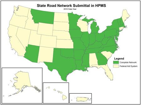 State Road Network submittal in highway Performance Monitoring System (HPMS). |
Vegetation Subcommittee
- Developed the National Vegetation Classification Standard Logo.
- Agreed on the development of keys for the National Vegetation Classification.
- Met with the Ecological Society of America Vegetation Panel and established a naming peer review process.
- Revised the National Vegetation Classification Standard Implementation Plan.

Wetlands Subcommittee
- Conducted outreach under the Implementation Plan for the Wetlands Mapping Standard through support of the Association of State Wetlands Managers and the Wetlands Mapping Consortium.
- Published a new online wetland mapping course.
- Conducted a multi-organization Working Group maintenance review of the Wetlands Classification Standard.
The Architecture and Technology Working Group
- Focused on support for the Technical Deployment Task Team to prototype a Geospatial Platform proof-of-concept, and the management of the Geospatial Cloud Sandbox Initiative, known as GeoCloud. For more information click here.
Metadata Working Group
- Worked collectively to explore International Standards Organization (ISO) geospatial metadata standards implementation.
- Through quarterly teleconferences and email discussions, the members of the working group have shared information about the status of the standards, issues addressed when applying the standards, software tools developed to support conversion from one standard to another, development of training materials and guidance documents, available metadata editors, and ideas for transitioning from the current FGDC metadata standard (Content Standard for Digital Geospatial Metadata, or CSDGM) to the ISO format.
FGDC Standards Working Group
- The Working Group recommended FGDC endorsement of the United States Thoroughfare, Landmark, and Postal Address Data Standard and the Federal Trails Data Standard. The FGDC endorsed the standards in February 2011.
- Working Group members served on NSDI Cooperative Agreements Program review panels to recommend proposals for standards development or implementation.
User/Historical Data Working Group
- Began a program of outreach to perspective members. To this end, a listserv was set up through the Library of Congress for Working Group members and those interested in its work (sun8.loc.gov/listarch/uhdwg.html).
- Began monthly Web and phone meetings for members to discuss issues. Various projects have been generated from these meetings, including:
-
- GeoPlatform Version 3 Users/Historical Data Working Group Collected Comments,
- FGDC Users/Historical Data Working Group Information Sheet, and
- Survey of Geospatial Data Managers and Databases in the Federal Government (ongoing).
FGDC Goals for Fiscal Year 2012
Geospatial Line of Business
- Develop Office of Management and Budget (OMB) Circular A–16 Supplemental Guidance implementation plans that support portfolio management.
- Implement roles and responsibilities identified in the Supplemental Guidance that support adoption of National Geospatial Digital Asset (NGDA) portfolio management.
- Develop and host targeted trainings around Supplemental Guidance implementation that support the vision for Federal NGDA portfolio management.
Portfolio Management
- Implement the portfolio management roles and responsibilities of the OMB Circular A–16 Supplemental Guidance.
- Refine the inventory of the NGDA datasets and themes.
- Identify potential automated systems to support performance measurement for the NGDA dataset and themes that can be offered through the Geospatial Platform.
Geospatial Platform
- Develop an implementation plan for the outreach/communication strategy in support of the Geospatial Platform.
- Deploy Version 1.0 capabilities for the Geospatial Platform in the Cloud environment in concert with Data.gov.
- Identify and launch pilot geospatial services and (or) applications on www.GeoPlatform.gov.
- Develop high-level requirements for offering infrastructure, data, and software as services on the Geospatial Platform.
Geospatial One-Stop and Data.gov
- The primary goal in 2012 will be completing the migration or integration of the Geospatial One-Stop catalog and capabilities into the Data.gov environment hosted by the U.S General Services Administration.
GeoCloud Sandbox Initiative
- In fiscal year 2012, the GeoCloud Sandbox Initiative seeks to continue deployment of the open source and commercial Cloud images for a new set of projects with a targeted focus on common services and data services for the Geospatial Platform and OMB Circular A–16 data.
National Geospatial Advisory Committee
- The National Geospatial Advisory Committee (NGAC) will hold three to four public meetings in fiscal year 2012.
- The NGAC will provide ongoing review, feedback, and recommendations regarding the development and implementation of key issues and initiatives, including innovative strategies for geospatial programs and partnerships, the Geospatial Platform, geospatial workforce development, emerging technologies, and partnerships with Tribal governments. These areas will be a primary focus of the NGAC’s work.
- The FGDC will review and respond to advice and recommendations from NGAC.
- The FGDC will complete the next cycle of NGAC nominations and appointments.
Standards
- The Coastal and Marine Ecological Classification Standard (CMECS) will go forward for FGDC endorsement.
- Additional external standards from ISO, ANSI, OGC, and other sources will be submitted for FGDC recognition in 2012. In this regard, the FGDC will leverage the resources of the Geospatial-Intelligence Standards Working Group to identify and recommend standards from ISO, ANSI, OGC, and other sources for FGDC recognition and use by FGDC member agencies.
Metadata
- Initiate the National Spatial Data Infrastructure stakeholder transition from the Content Standard for Digital Geospatial Metadata (CSDGM) to the ISO suite of geospatial metadata standards.
- Increase the number and type of online resources available from the FGDC Geospatial Metadata website and organize the information so that resources are more easily accessed.
Fifty States Initiative
- In fiscal year 2012, eight NSDI Cooperative Agreements Program awards are planned for the Fifty States Initiative, with a kickoff meeting in spring 2012. The initiative will continue to support the Geospatial Platform.
International Activities
- The Global Spatial Data Infrastructure (GSDI) Small Grants Program will award up to eighteen projects that will support the advancement of spatial data infrastructures in developing countries around the world.
- In terms of goals for the Group on Earth Observations/Global Earth Observation System of Systems (GEO/GEOSS), a current focus is on simplifying access to quality Earth observation data and services. This will be achieved through enhancements to the existing portal and search components, two of which are hosted and maintained by the FGDC/USGS.
NSDI Training
- Enhance the Web presentation of materials by utilizing Online Learning System technology and organizing the formation so that resources are more easily accessed.
- Expand the number and type of online training materials available to NSDI stakeholders.
FGDC Subcommittee and Working Groups
Cadastral Subcommittee
- The Cadastral Subcommittee’s Federal Parcel Work Group will develop a draft core data standard for Federal parcel data and develop a strategy to implement it.
Cultural and Demographic Statistics Subcommittee
- United States Thoroughfare, Landmark, and Postal Address Data Standard—Completion of profiles of the standard that will work with the U.S. Postal Service’s Publication 28 and the National Emergency Numbering Association’s Next Generation 9-1-1 Civic Location Data Exchange Format Standard.
Geodetic Control Subcommittee
- Continue education, outreach, development of transition tools and applications, and capacity-building activities to prepare users for the transition to new geometric and geopotential datums. These activities will converge at the National Geodetic Survey’s second Geospatial Summit, which will be held in San Diego, California, in July 2012.
- Identify common objectives and find opportunities for cooperative projects and tasks related to standardization and updates to vertical datums.
- Within each Federal agency, identify products and services that will be impacted by new vertical datums.
- Update existing guidelines, standards, and specifications to support the transition to new vertical datums.
Geologic Subcommittee
- Coordinate with various agencies in the United States and Canada to create an Esri “style file” implementation of the FGDC Geologic Map Symbolization standard. Work with Esri regarding revisions to their Cartographic Representations implementation of the Standard.
- The Standard was published in 2006; since then, suggestions for revisions have been received and compiled. In 2012, pending available funding, begin the first update to the Standard. Release revised sections to the Standard as appropriate.
- Evaluate the “NCGMP09” database design for publication of geologic maps that was proposed by the U.S. Geological Survey. Evaluate database designs used by other agencies. Work toward consensus on an overall Federal standard design, or standard database elements (such as common science terms and database field names).
Marine and Coastal Spatial Data Subcommittee
- Release of the Coastal and Marine Spatial Planning National Information Management System (NIMS) Prototype Portal.
- FGDC adoption of the Coastal and Marine Ecological Classification Standard (CMECS).
National Digital Orthoimagery Program (NDOP) Subcommittee
- Future NDOP plans include devising a new 3-year NAIP partnership agreement. All agencies that use NAIP imagery are encouraged to contribute to the plan.
Spatial Water Data Subcommittee
- The Subcommittee, mindful of the framework for services-oriented architecture, will focus on the national delivery of water quality and quantity results using standard geography, GIS, and internationally adopted standards to harmonize the delivery of sampling points and time series data on flow, water levels, water quantity, and water quality.
- The Subcommittee for Spatial Water Data will begin contacting Federal water agencies to work with them to assess what would be the advantages, disadvantages, and level of effort involved in implementing this services-oriented architecture.
Transportation Subcommittee
- Identify a baseline of transportation datasets (non-road) that would complete Transportation for the Nation.
- Identify issues and solutions on how to utilize transportation geospatial data that would contribute to livability analyses in the coming years.
Vegetation Subcommittee
- Host a field trip and organized session for the 2012 Ecological Society of America annual meeting.
- Develop a training workshop related to the use of the National Vegetation Classification Standard in Federal agency activities.
- For the National Vegetation Classification, review the basic statements in the key concepts document.
- Complete the Permanent Housing database, establish a database system between Federal agencies, and improve system communication between Federal and non-Federal vegetation databases.
- Foster international collaboration efforts.
Wetlands Subcommittee
- Continue outreach for the Wetlands Mapping Standard and expand the training course and opportunities.
- Submit the Wetlands Classification Standard proposed maintenance update through the Federal Register for public review and comment.
The Architecture and Technology Working Group
- In the coming year the Working Group will oversee a second year of GeoCloud hosting and facilitation using the two developed reference platform software ”stacks” for open-source and commercial geospatial solutions.
- Foster international collaboration efforts.
Metadata Working Group
- Inform members about ISO metadata and support members in ISO metadata implementation.
FGDC Standards Working Group
- Follow up on findings from the standards use survey. For more information click here.
- Identify and recommend ISO, ANSI, and OGC standards for FGDC endorsement in support of the Geospatial Platform.
- Evaluate interconnections among standards bodies and what voting by FGDC member agencies in external standards bodies signifies.
- Review the FGDC standards program of work to identify standards that should be retired or revised and standards projects that should be discontinued.
- Review and recommend the Coastal and Marine Ecological Classification Standard (CMECS) for FGDC endorsement.
User/Historical Data Working Group
- Continue outreach to all interested parties, both inside and outside the Federal Government.
- Continue to provide input on the Geospatial Platform.
- Provide coordinated input to the Library of Congress Geospatial Data Preservation Resource Center.
- Inventory guidance documents on geospatial formats for long-term preservation and access.

